Map of Alliance town

Map of Alliance town, North Carolina

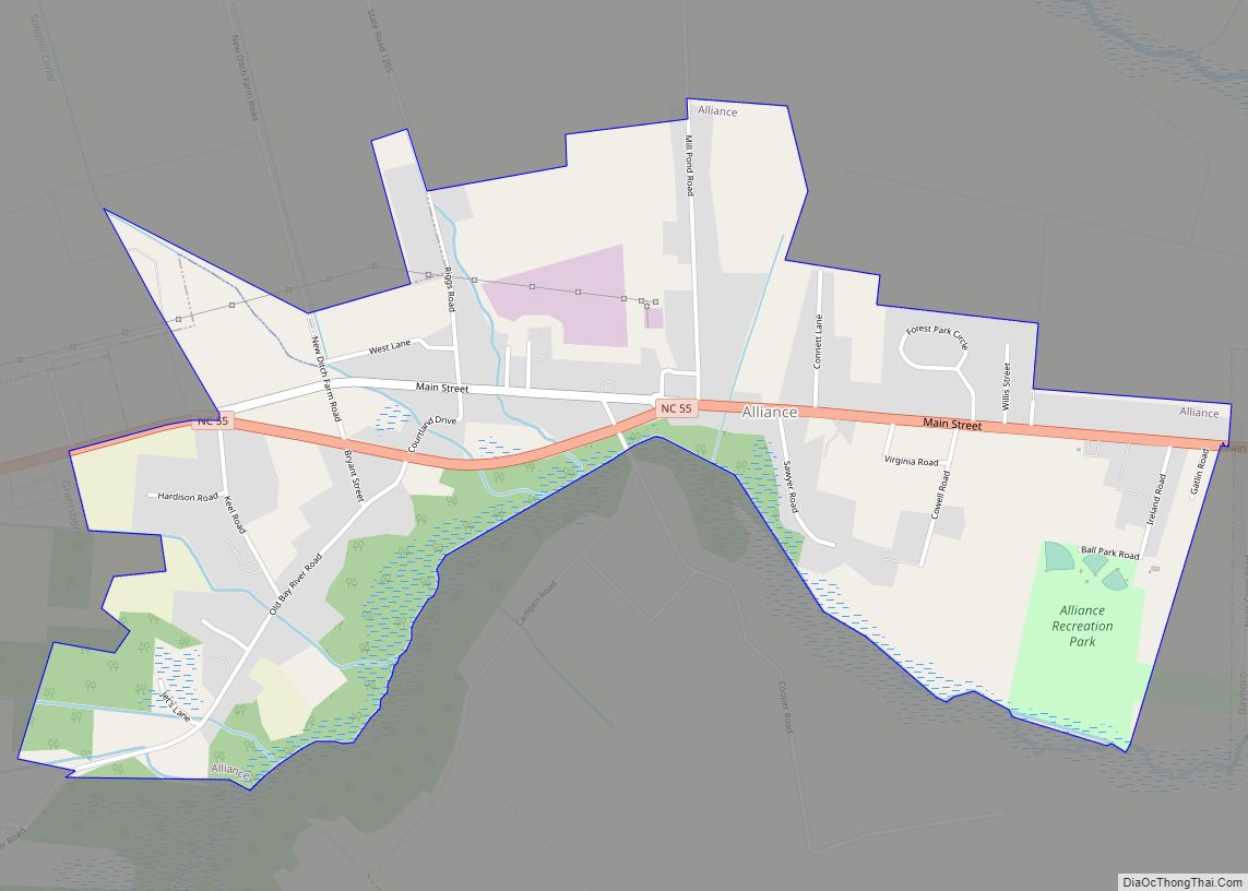
Alliance is a town in Pamlico County, North Carolina, United States. Its name is derived from the Farmers Alliance Movement from around 1874, two years after Pamlico was founded. Alliance was incorporated in 1965. The majority of land in Alliance is farmland. The population was 776 at the 2010 census. It is part of the … Read more

Map of Albemarle city

Map of Albemarle city

Albemarle (/ˈælbəˌmɑːrl/) is a city in and the county seat of Stanly County, North Carolina, United States. The population was 15,903 in the 2010 Census. Gerald R. “Ronnie” Michael (a former police chief in the city) serves as Mayor and Albemarle has a seven-member City Council elected in a combination of at-large and district seats. … Read more

Map of Alamance village

Map of Alamance village

Alamance is a village in Alamance County, North Carolina, United States. It is part of the Burlington, North Carolina Metropolitan Statistical Area. The population was 951 at the 2010 census, up from 310 at the 2000 census. Alamance village overview: Name: Alamance village LSAD Code: 47 LSAD Description: village (suffix) State: North Carolina County: Alamance … Read more

Map of Ahoskie town

Map of Ahoskie town

Ahoskie /əˈhɒski/ (listen) is a town in Hertford County, North Carolina, United States. The population was 5,039 at the 2010 census. Ahoskie is located in North Carolina’s Inner Banks region. Its nickname is “The Only One” because no other town in the world is known by the same name. The etymology of the word Ahoskie, … Read more

Map of Advance CDP, North Carolina

Map of Advance CDP, North Carolina

Advance (pronounced with the stress on the first syllable) is an unincorporated community and census-designated place (CDP) in Davie County, North Carolina, United States. It is seventy-five miles northeast of Charlotte. As of the 2010 census it had a population of 1,138. It is located along North Carolina Highway 801 just south of Bermuda Run. … Read more

Map of Aberdeen town, North Carolina

Map of Aberdeen town, North Carolina

Aberdeen is a town in Moore County, North Carolina, United States. The population was 6,350 at the 2010 census. Aberdeen town overview: Name: Aberdeen town LSAD Code: 43 LSAD Description: town (suffix) State: North Carolina County: Moore County Incorporated: 1893 Elevation: 344 ft (105 m) Total Area: 10.63 sq mi (27.52 km²) Land Area: 10.44 sq mi (27.04 km²) Water Area: 0.19 sq mi (0.48 km²) … Read more

Map of Archer Lodge town

Map of Archer Lodge town

Archer Lodge is a town in Johnston County, North Carolina, United States. Its population was 4,292 as of the 2010 census, and as of 2018 the estimated population was 5,014. Archer Lodge town overview: Name: Archer Lodge town LSAD Code: 43 LSAD Description: town (suffix) State: North Carolina County: Johnston County Incorporated: 2009 Elevation: 338 ft … Read more

Map of Archdale city

Map of Archdale city

Archdale is a city in Guilford and Randolph counties in the U.S. state of North Carolina. Located 15 miles southwest of Greensboro, it is part of the Greensboro-High Point Metropolitan Statistical Area of the Piedmont Triad metro region. The population was 11,415 at the 2010 census, up from 9,014 in 2000. Archdale city overview: Name: … Read more

Map of Arapahoe town

Map of Arapahoe town, North Carolina

Arapahoe (/əˈræpəhoʊ/) is a town in Pamlico County, North Carolina, United States. As of the 2010 census, the town population was 556. Arapahoe shares many of its roles and duties with Minnesott Beach, North Carolina. It is part of the New Bern, North Carolina Micropolitan Statistical Area. Arapahoe town overview: Name: Arapahoe town LSAD Code: … Read more

Map of Aquadale CDP

Map of Aquadale CDP

Aquadale is an unincorporated community and census-designated place in Stanly County, North Carolina, United States. Its population was 397 as of the 2010 census. Aquadale CDP overview: Name: Aquadale CDP LSAD Code: 57 LSAD Description: CDP (suffix) State: North Carolina County: Stanly County Elevation: 459 ft (140 m) Total Area: 3.25 sq mi (8.43 km²) Land Area: 3.25 sq mi (8.43 km²) Water … Read more

Map of Apex town

Map of Apex town

Apex (/ˈeɪ.pɛks/) is a town in Wake County, North Carolina, United States. At its southern border, Apex encompasses the community of Friendship. In 1994, the downtown area was designated a historic district, and the Apex train depot, built in 1867, is designated a Wake County landmark. The depot location marks the highest point on the … Read more

Map of Ansonville town

Map of Ansonville town

Ansonville is a town in Anson County, North Carolina, United States. The population was 421 at the 2020 census. Ansonville town overview: Name: Ansonville town LSAD Code: 43 LSAD Description: town (suffix) State: North Carolina County: Anson County Founded: 1844 Incorporated: 1885 Elevation: 331 ft (101 m) Total Area: 1.47 sq mi (3.81 km²) Land Area: 1.47 sq mi (3.81 km²) Water Area: … Read more