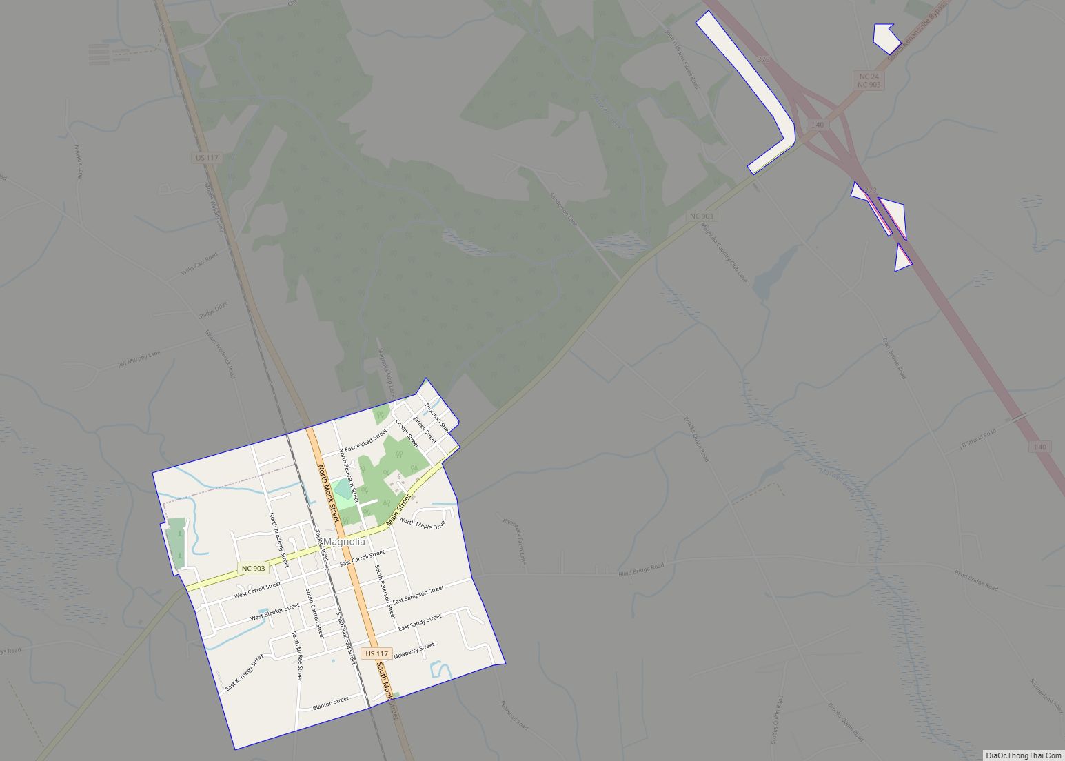
Map of Maggie Valley town

Map of Maggie Valley town

Maggie Valley is a town in Haywood County, North Carolina, United States. The population was 1,150 at the 2010 census. A popular tourist destination, it is home to Cataloochee Ski Area and the former Ghost Town in the Sky amusement park. Maggie Valley is part of the Asheville Metropolitan Statistical Area. The community gets its … Read more

Map of Madison town, North Carolina

Map of Madison town, North Carolina

Madison is a town located in Rockingham County, North Carolina. At the 2020 census, the town had a total population of 2,132. Madison is part of the Greensboro-High Point Metropolitan Statistical Area of the Piedmont Triad metro region. It was home to the corporate headquarters of Remington Arms until 2020, when the company was made … Read more

Map of Marshallberg CDP

Map of Marshallberg CDP

Marshallberg is an unincorporated area and census-designated place (CDP) in Carteret County, North Carolina, United States. As of the 2010 census it had a population of 403. It lies on the mainland, directly across Core Sound from Harkers Island and Cape Lookout beyond that. Lying at the extreme southeast corner of a peninsula, it is … Read more

Map of Marshall town, North Carolina

Map of Marshall town, North Carolina

Marshall is a town in Madison County, North Carolina, United States. The population was 872 at the 2010 census. It is the county seat of Madison County. Marshall is part of the Asheville Metropolitan Statistical Area. Marshall town overview: Name: Marshall town LSAD Code: 43 LSAD Description: town (suffix) State: North Carolina County: Madison County … Read more

Map of Mars Hill town, North Carolina

Map of Mars Hill town, North Carolina

Mars Hill is a town in Madison County, North Carolina, United States. The population was 1,869 at the 2010 U.S. Census, and was estimated at 2,032 in 2018 by the U.S. Census. It is the home of Mars Hill University, the name of which was inspired by Acts 17:22. The town is located 15 miles … Read more

Map of Marion city, North Carolina

Map of Marion city, North Carolina

Marion is a city in and the county seat of McDowell County, North Carolina, United States. Founded in 1844, the city was named in honor of Brigadier General Francis Marion, the American Revolutionary War Hero whose talent in guerrilla warfare earned him the name “Swamp Fox”. Marion’s Main Street Historic District is listed on the … Read more

Map of Marietta town, North Carolina

Map of Marietta town, North Carolina

Marietta is a town located in Robeson County, North Carolina, United States. As of the 2010 census, the town had a total population of 175. Marietta town overview: Name: Marietta town LSAD Code: 43 LSAD Description: town (suffix) State: North Carolina County: Robeson County Elevation: 89 ft (27 m) Total Area: 1.12 sq mi (2.89 km²) Land Area: 1.12 sq mi (2.89 km²) … Read more

Map of Marble CDP, North Carolina

Map of Marble CDP, North Carolina

Marble is an unincorporated community and census-designated place (CDP) in Cherokee County, North Carolina, United States. As of the 2010 census it had a population of 321. Marble’s elevation is 1,680 feet (510 m) above sea level. Marble CDP overview: Name: Marble CDP LSAD Code: 57 LSAD Description: CDP (suffix) State: North Carolina County: Cherokee County … Read more

Map of Mar-Mac CDP

Map of Mar-Mac CDP

Mar-Mac is a census-designated place (CDP) in Wayne County, North Carolina, United States. The population was 3,011 at the 2007 census. It is included in the Goldsboro, North Carolina Metropolitan Statistical Area. Mar-Mac CDP overview: Name: Mar-Mac CDP LSAD Code: 57 LSAD Description: CDP (suffix) State: North Carolina County: Wayne County Elevation: 112 ft (34 m) Total … Read more

Map of Manteo town

Map of Manteo town

Manteo (/ˈmæn(t)i.oʊ/) is a town in Dare County, North Carolina, United States, located on Roanoke Island. The population was 1,602 at the 2020 census. It is the county seat of Dare County. Manteo town overview: Name: Manteo town LSAD Code: 43 LSAD Description: town (suffix) State: North Carolina County: Dare County Founded: 1865 Incorporated: 1899 … Read more

Map of Manns Harbor CDP

Map of Manns Harbor CDP

Manns Harbor CDP overview: Name: Manns Harbor CDP LSAD Code: 57 LSAD Description: CDP (suffix) State: North Carolina County: Dare County FIPS code: 3740980 Online Interactive Map Manns Harbor online map. Source: Basemap layers from Google Map, Open Street Map (OSM), Arcgisonline, Wmflabs. Boundary Data from Database of Global Administrative Areas. Manns Harbor location map. … Read more

Map of Mamers CDP

Map of Mamers CDP

Mamers is an unincorporated community and census-designated place (CDP) in Harnett County, North Carolina, United States. The population was 826 at the 2010 census. It is a part of the Dunn Micropolitan Area, which is also a part of the greater Raleigh–Durham–Cary Combined Statistical Area (CSA) as defined by the United States Census Bureau. Mamers … Read more