Map of Beech Mountain town

Map of Beech Mountain town

Beech Mountain is a town in both Avery and Watauga counties in the U.S. state of North Carolina. As of the 2010 census, the town population was 320. The town is located atop Beech Mountain and is the highest town east of the Rocky Mountains at 5,506 ft (1,678 m) in elevation. The nearest municipality at … Read more

Map of Beaufort town

Map of Beaufort town, North Carolina

Beaufort (/ˈboʊfərt/ BOH-fərt) is a town in and the county seat of Carteret County, North Carolina, United States. Established in 1713 and incorporated in 1723, Beaufort is the fourth oldest town in North Carolina (after Bath, New Bern and Edenton). On February 1, 2012, Beaufort was ranked as “America’s Coolest Small Town” by readers of … Read more

Map of Bear Grass town

Map of Bear Grass town

Bear Grass is a town in Martin County, North Carolina, United States. The population was 73 at the 2010 census. Bear Grass town overview: Name: Bear Grass town LSAD Code: 43 LSAD Description: town (suffix) State: North Carolina County: Martin County Elevation: 56 ft (17 m) Total Area: 0.25 sq mi (0.66 km²) Land Area: 0.25 sq mi (0.66 km²) Water Area: 0.00 sq mi … Read more

Map of Bayview CDP, North Carolina

Map of Bayview CDP, North Carolina

Bayview is an unincorporated community and census-designated place (CDP) in Beaufort County, North Carolina, United States. As of the 2010 census, it had a population of 346. The community is located on the north bank of the Pamlico River, south of North Carolina Highway 92. Bayview CDP overview: Name: Bayview CDP LSAD Code: 57 LSAD … Read more

Map of Bayshore CDP

Map of Bayshore CDP

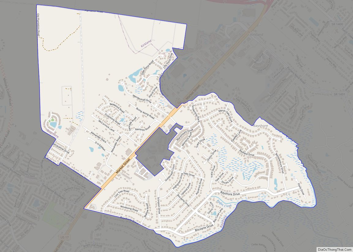
Bayshore is a census-designated place (CDP) in New Hanover County, North Carolina, United States. The population was 3,393 at the 2010 census. It is part of the Wilmington Metropolitan Statistical Area. Bayshore CDP overview: Name: Bayshore CDP LSAD Code: 57 LSAD Description: CDP (suffix) State: North Carolina County: New Hanover County Elevation: 7 ft (2 m) Total … Read more

Map of Belvoir CDP

Map of Belvoir CDP

Belvoir is a census-designated place within Belvoir Township, Pitt County, North Carolina, United States. As of the 2010 census it had a population of 307. It is located six miles northwest of Greenville along North Carolina Highway 222. Belvoir CDP overview: Name: Belvoir CDP LSAD Code: 57 LSAD Description: CDP (suffix) State: North Carolina County: … Read more

Map of Belville town

Map of Belville town

Belville is a town in Brunswick County, North Carolina, United States. The population was 1,936 at the 2010 census, up from 285 in 2000. It is part of the Wilmington, NC metropolitan area. Belville town overview: Name: Belville town LSAD Code: 43 LSAD Description: town (suffix) State: North Carolina County: Brunswick County Elevation: 25 ft (8 m) … Read more

Map of Belmont city, North Carolina

Map of Belmont city, North Carolina

Belmont is a small suburban city in Gaston County, North Carolina, United States, located about 13 miles (21 km) west of uptown Charlotte and 9 miles (14 km) east of Gastonia. The population was 10,076 at the 2010 census. Once known as Garibaldi Station, it was named for the New York banker August Belmont. Belmont is home … Read more

Map of Bell Arthur CDP

Map of Bell Arthur CDP

Bell Arthur (also known as Bellarthur) is an unincorporated community and census-designated place (CDP) in Pitt County, North Carolina, United States. Its population was 466 as of the 2010 census. Bell Arthur has a post office with ZIP code 27811. Bell Arthur CDP overview: Name: Bell Arthur CDP LSAD Code: 57 LSAD Description: CDP (suffix) … Read more

Map of Belhaven town

Map of Belhaven town

Belhaven is a waterfront town in Beaufort County, North Carolina, United States. The population was 1,688 at the 2010 Census. Belhaven is located in North Carolina’s Inner Banks region. Belhaven town overview: Name: Belhaven town LSAD Code: 43 LSAD Description: town (suffix) State: North Carolina County: Beaufort County Elevation: 0 ft (0 m) Total Area: 2.09 sq mi (5.41 km²) … Read more

Map of Beulaville town

Map of Beulaville town

Beulaville is a town located in Duplin County, North Carolina, United States. The population was 1,296 as of 2010, making it the fourth most populous town in the county. The community lies within Limestone Creek Township. Beulaville town overview: Name: Beulaville town LSAD Code: 43 LSAD Description: town (suffix) State: North Carolina County: Duplin County … Read more

Map of Bethlehem CDP, North Carolina

Map of Bethlehem CDP, North Carolina

Bethlehem CDP overview: Name: Bethlehem CDP LSAD Code: 57 LSAD Description: CDP (suffix) State: North Carolina County: Alexander County FIPS code: 3705530 Online Interactive Map Bethlehem online map. Source: Basemap layers from Google Map, Open Street Map (OSM), Arcgisonline, Wmflabs. Boundary Data from Database of Global Administrative Areas. Bethlehem location map. Where is Bethlehem CDP? … Read more