Map of South Henderson CDP

Map of South Henderson CDP

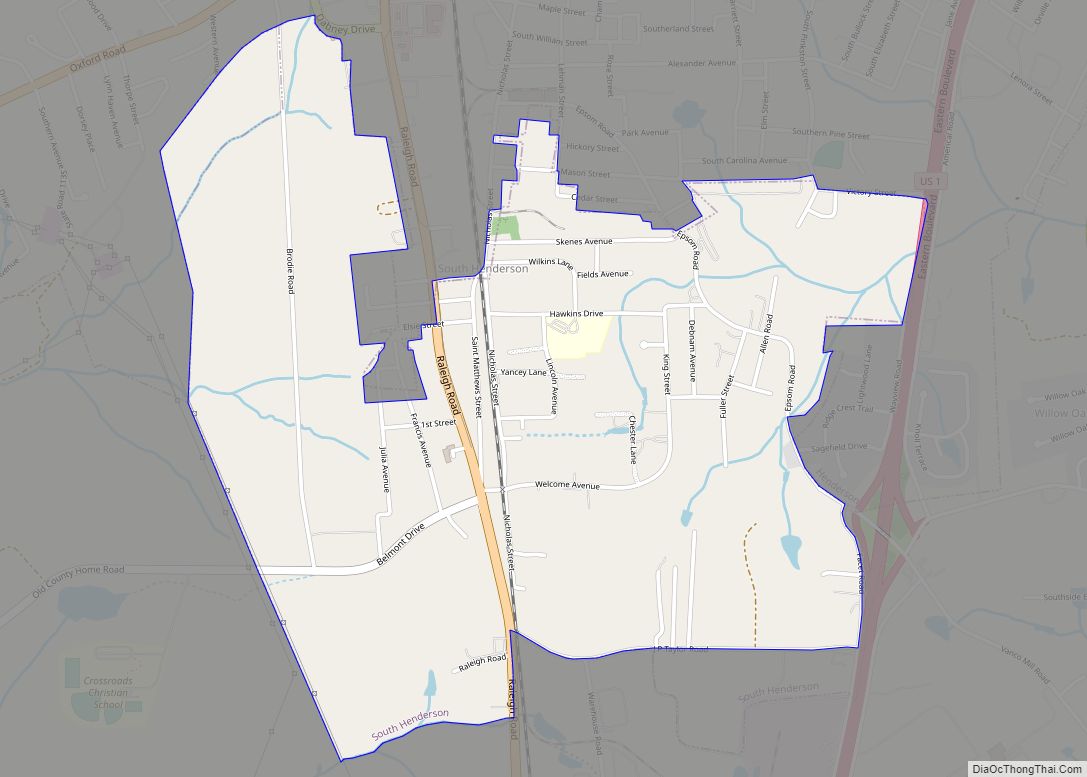
South Henderson is a census-designated place (CDP) in Vance County, North Carolina, United States. The population was 1,213 at the 2010 census. South Henderson CDP overview: Name: South Henderson CDP LSAD Code: 57 LSAD Description: CDP (suffix) State: North Carolina County: Vance County Elevation: 505 ft (154 m) Total Area: 1.80 sq mi (4.67 km²) Land Area: 1.80 sq mi (4.67 km²) Water … Read more

Map of Snow Hill town, North Carolina

Map of Snow Hill town, North Carolina

Snow Hill is a town in Greene County, North Carolina, United States. The population was 1,595 at the 2010 census. It is the county seat of Greene County and is part of the Greenville Metropolitan Area. Snow Hill hosts numerous tennis tournaments during the year. Snow Hill is home to the Green Ridge Racquet Club. … Read more

Map of Sneads Ferry CDP

Map of Sneads Ferry CDP

Sneads Ferry is a census-designated place (CDP) in Onslow County, North Carolina, United States. It is the second largest municipality in Onslow County, behind Jacksonville and is part of the Jacksonville, North Carolina Metropolitan Statistical Area. Once a rural fishing village, Sneads Ferry has experienced a surge in development since 2000. Based on U.S. Census … Read more

Map of Smithfield town, North Carolina

Map of Smithfield town, North Carolina

Smithfield is a town in and the county seat of Johnston County, North Carolina, United States. As of the 2010 census, its population was 10,966, and in 2019 the estimated population was 12,985. Smithfield is home to the Ava Gardner Museum and is situated along the Neuse River, where visitors enjoy the annual Smithfield Ham … Read more

Map of Skippers Corner CDP

Map of Skippers Corner CDP

Skippers Corner is a census-designated place (CDP) in New Hanover County, North Carolina, United States. The population was 2,785 at the 2010 census, up from 1,246 in 2000. It is part of the Wilmington Metropolitan Statistical Area. Skippers Corner CDP overview: Name: Skippers Corner CDP LSAD Code: 57 LSAD Description: CDP (suffix) State: North Carolina … Read more

Map of Sims town, North Carolina

Map of Sims town, North Carolina

Sims is a town in Wilson County, North Carolina, United States. The population was 282 at the 2010 census. Sims town overview: Name: Sims town LSAD Code: 43 LSAD Description: town (suffix) State: North Carolina County: Wilson County Elevation: 197 ft (60 m) Total Area: 0.22 sq mi (0.57 km²) Land Area: 0.22 sq mi (0.57 km²) Water Area: 0.00 sq mi (0.00 km²) Total Population: … Read more

Map of Simpson village, North Carolina

Map of Simpson village, North Carolina

Simpson is a village in Pitt County, North Carolina, United States. The population was 416 at the 2010 census. The village is a part of the Greenville Metropolitan Area. Simpson village overview: Name: Simpson village LSAD Code: 47 LSAD Description: village (suffix) State: North Carolina County: Pitt County Elevation: 62 ft (19 m) Total Area: 0.37 sq mi (0.96 km²) … Read more

Map of Silver Lake CDP, North Carolina

Map of Silver Lake CDP, North Carolina

Silver Lake is a census-designated place in New Hanover County, North Carolina, United States. The population was 5,598 at the 2010 census, down from 5,788 in 2000. It is part of the Wilmington Metropolitan Statistical Area. Silver Lake CDP overview: Name: Silver Lake CDP LSAD Code: 57 LSAD Description: CDP (suffix) State: North Carolina County: … Read more

Map of South Weldon CDP

Map of South Weldon CDP

South Weldon is an unincorporated community and census-designated place (CDP) in Halifax County, North Carolina, United States. As of the 2010 census, the CDP population was 705. It is part of the Roanoke Rapids, North Carolina Micropolitan Statistical Area. South Weldon CDP overview: Name: South Weldon CDP LSAD Code: 57 LSAD Description: CDP (suffix) State: … Read more

Map of Spindale town

Map of Spindale town

Spindale is a town in Rutherford County, North Carolina, United States. The population was 4,321 at the 2010 census. Spindale town overview: Name: Spindale town LSAD Code: 43 LSAD Description: town (suffix) State: North Carolina County: Rutherford County Elevation: 1,089 ft (332 m) Total Area: 5.41 sq mi (14.01 km²) Land Area: 5.41 sq mi (14.01 km²) Water Area: 0.00 sq mi (0.00 km²) Total Population: … Read more

Map of Spencer town, North Carolina

Map of Spencer town, North Carolina

Spencer is a town in Rowan County, North Carolina, United States, incorporated in 1905. As of the 2010 census, the town population was 3,267. Spencer town overview: Name: Spencer town LSAD Code: 43 LSAD Description: town (suffix) State: North Carolina County: Rowan County Elevation: 715 ft (218 m) Total Area: 3.07 sq mi (7.95 km²) Land Area: 3.07 sq mi (7.95 km²) Water … Read more

Map of Spencer Mountain town

Map of Spencer Mountain town

Spencer Mountain is a town in Gaston County, North Carolina, United States. The population was 37 at the 2010 census. Spencer Mountain town overview: Name: Spencer Mountain town LSAD Code: 43 LSAD Description: town (suffix) State: North Carolina County: Gaston County Incorporated: 1963 Elevation: 679 ft (207 m) Total Area: 0.54 sq mi (1.40 km²) Land Area: 0.49 sq mi (1.26 km²) Water … Read more