Map of Blowing Rock town

Map of Blowing Rock town

Blowing Rock is a town in Watauga and Caldwell counties in the U.S. state of North Carolina. The population was 1,397 at the 2021 census. The Caldwell County portion of Blowing Rock is part of the Hickory–Lenoir–Morganton Metropolitan Statistical Area, while the Watauga County portion is part of the Boone Micropolitan Statistical Area. Blowing Rock … Read more

Map of Bladenboro town

Map of Bladenboro town

Bladenboro is a town in Bladen County, North Carolina, United States. As of the 2010 census, the town population was 1,750. Bladenboro town overview: Name: Bladenboro town LSAD Code: 43 LSAD Description: town (suffix) State: North Carolina County: Bladen County Elevation: 102 ft (31 m) Total Area: 2.21 sq mi (5.74 km²) Land Area: 2.21 sq mi (5.74 km²) Water Area: 0.00 sq mi (0.00 km²) … Read more

Map of Black Mountain town

Map of Black Mountain town

Black Mountain is a town in Buncombe County, North Carolina, United States. The population was 7,848 at the 2010 census. It is part of the Asheville Metropolitan Statistical Area. The town is named for the old train stop at the Black Mountain Depot and is located at the southern end of the Black Mountain range … Read more

Map of Black Creek town

Map of Black Creek town, North Carolina

Black Creek is a town in Wilson County, North Carolina, United States. The population was 769 at the 2010 census. Black Creek town overview: Name: Black Creek town LSAD Code: 43 LSAD Description: town (suffix) State: North Carolina County: Wilson County Elevation: 125 ft (38 m) Total Area: 0.71 sq mi (1.84 km²) Land Area: 0.71 sq mi (1.83 km²) Water Area: 0.00 sq mi … Read more

Map of Biscoe town

Map of Biscoe town

Biscoe is a town in Montgomery County, North Carolina, United States. The population was 1,700 at the 2010 census. The town is named after Henry Biscoe, an important customer of the local lumber business. Biscoe town overview: Name: Biscoe town LSAD Code: 43 LSAD Description: town (suffix) State: North Carolina County: Montgomery County Elevation: 614 ft … Read more

Map of Biltmore Forest town

Map of Biltmore Forest town

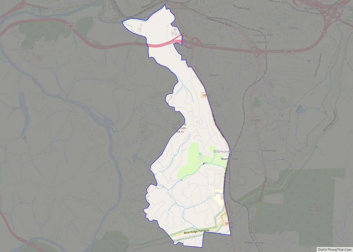
Biltmore Forest is a town in Buncombe County, North Carolina, United States. The population was 1,343 in 2010. It is part of the Asheville Metropolitan Statistical Area. Biltmore Forest is the second-wealthiest town in North Carolina by per capita income at $85,044. Biltmore Forest town overview: Name: Biltmore Forest town LSAD Code: 43 LSAD Description: … Read more

Map of Boiling Springs town

Map of Boiling Springs town, North Carolina

Boiling Springs is a town in Cleveland County, North Carolina, United States and is located in the westernmost part of the Charlotte metropolitan area, located approximately 50 miles away from the city. As of the 2010 census, the town’s population was 4,647. It is home to Gardner–Webb University. The town is named after the natural … Read more

Map of Brices Creek CDP

Map of Brices Creek CDP

Brices Creek is an unincorporated area and census-designated place (CDP) in Craven County, North Carolina, United States. The population was 3,073 at the 2010 census. It is part of the New Bern, North Carolina Metropolitan Statistical Area. Brices Creek CDP overview: Name: Brices Creek CDP LSAD Code: 57 LSAD Description: CDP (suffix) State: North Carolina … Read more

Map of Brevard city

Map of Brevard city

Brevard is a city and the county seat of Transylvania County, North Carolina, United States, with a population of 7,609 as of the 2010 Census. Brevard is located at the entrance to Pisgah National Forest and has become a noted tourism, retirement and cultural center in western North Carolina. A moderate climate, environmental beauty and … Read more

Map of Bowmore CDP

Map of Bowmore CDP

Bowmore is an unincorporated community and census-designated place (CDP) in Hoke County, North Carolina, United States. The population was 103 at the 2010 census. Bowmore CDP overview: Name: Bowmore CDP LSAD Code: 57 LSAD Description: CDP (suffix) State: North Carolina County: Hoke County Elevation: 259 ft (79 m) Total Area: 3.31 sq mi (8.59 km²) Land Area: 3.31 sq mi (8.59 km²) Water … Read more

Map of Bostic town

Map of Bostic town

Bostic is a town in Rutherford County, North Carolina, United States. The population was 386 at the 2010 census. Bostic town overview: Name: Bostic town LSAD Code: 43 LSAD Description: town (suffix) State: North Carolina County: Rutherford County Elevation: 948 ft (289 m) Total Area: 0.93 sq mi (2.42 km²) Land Area: 0.93 sq mi (2.42 km²) Water Area: 0.00 sq mi (0.00 km²) Total Population: … Read more

Map of Boonville town, North Carolina

Map of Boonville town, North Carolina

Boonville is a town in Yadkin County, North Carolina, United States. The population was 1,222 at the 2010 census. Boonville town overview: Name: Boonville town LSAD Code: 43 LSAD Description: town (suffix) State: North Carolina County: Yadkin County Elevation: 1,099 ft (335 m) Total Area: 1.20 sq mi (3.11 km²) Land Area: 1.20 sq mi (3.11 km²) Water Area: 0.00 sq mi (0.00 km²) Total Population: … Read more