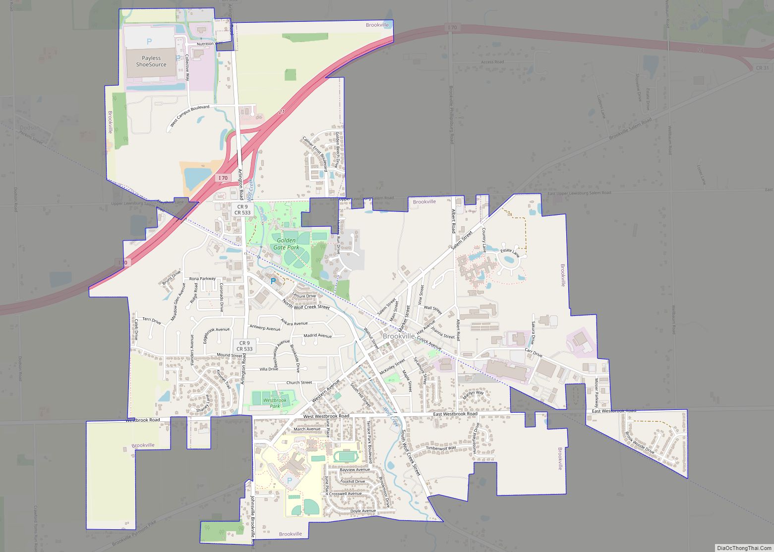
Map of Brimfield CDP, Ohio

Map of Brimfield CDP, Ohio

Brimfield is a census-designated place (CDP) in Portage County, Ohio, United States. As of the 2000 census, the CDP had a population of 3,248. It is located in the central part of Brimfield Township (of which it is a part), a rural area between the Ohio cities of Akron and Kent with light industry, strip-malls, … Read more

Map of Buchtel village

Map of Buchtel village

Buchtel is a village in Athens and Hocking counties in the U.S. state of Ohio, just northeast of Nelsonville. Located in the Hocking Valley, it was a center of coal mining in the late 19th and early 20th centuries. The population was 518 at the 2020 census. A former name for the village is Bessemer. … Read more

Map of Bryan city

Map of Bryan city, Ohio

Bryan is a city in, and the county seat of, Williams County, Ohio, United States. It is located in the state’s northwestern corner, 53 miles (85 km) southwest of Toledo. The population was 8,729 at the 2020 census. Bryan city overview: Name: Bryan city LSAD Code: 25 LSAD Description: city (suffix) State: Ohio County: Williams County … Read more

Map of Brunswick city, Ohio

Map of Brunswick city, Ohio

Brunswick (/ˈbrʌnzwɪk/ BRUN-zwik or /ˈbrʌnswɪk/ BRUN-swik) is the largest city in Medina County, Ohio, United States approximately 20 mi (32 km) SW of Cleveland. The population was 34,255 at the 2010 census and estimated at 34,880 as of 2019. It is part of the Cleveland Metropolitan Area. Brunswick city overview: Name: Brunswick city LSAD Code: 25 LSAD … Read more

Map of Burgoon village

Map of Burgoon village

Burgoon /ˈbɜːrɡuːn/ is a village in Sandusky County, Ohio, United States. The population was 172 at the 2010 census. Burgoon village overview: Name: Burgoon village LSAD Code: 47 LSAD Description: village (suffix) State: Ohio County: Sandusky County Elevation: 705 ft (215 m) Total Area: 0.14 sq mi (0.36 km²) Land Area: 0.14 sq mi (0.36 km²) Water Area: 0.00 sq mi (0.00 km²) Total Population: 183 … Read more

Map of Burbank village, Ohio

Map of Burbank village, Ohio

Burbank is a village in Wayne County, Ohio, United States, along Killbuck Creek. The population was 207 at the 2010 census. Burbank village overview: Name: Burbank village LSAD Code: 47 LSAD Description: village (suffix) State: Ohio County: Wayne County Elevation: 955 ft (291 m) Total Area: 0.36 sq mi (0.92 km²) Land Area: 0.36 sq mi (0.92 km²) Water Area: 0.00 sq mi (0.00 km²) Total … Read more

Map of Buford CDP, Ohio

Map of Buford CDP, Ohio

Buford is an unincorporated community and census-designated place in central Clay Township, Highland County, Ohio, United States. The population was 352 at the 2010 census. it once had a post office, with the ZIP code 45110. The current ZIP code 45171 is for nearby Sardinia. Buford CDP overview: Name: Buford CDP LSAD Code: 57 LSAD … Read more

Map of Buffalo CDP, Ohio

Map of Buffalo CDP, Ohio

Buffalo is an unincorporated community and census-designated place in eastern Valley Township, Guernsey County, Ohio, United States. As of the 2010 census it had a population of 401. It has a post office with the ZIP code 43722. It lies along State Route 313. Buffalo CDP overview: Name: Buffalo CDP LSAD Code: 57 LSAD Description: … Read more

Map of Bucyrus city, Ohio

Map of Bucyrus city, Ohio

Bucyrus (/bjuːˈsaɪrəs/ bew-SY-rəs) is a city in the U.S. state of Ohio and the county seat of Crawford County, located in northern Ohio approximately 28 miles (45 km) west of Mansfield and 66 miles (106 km) southeast of Toledo. The population was 11,684 at the 2020 census. The city is the largest in Crawford County, and the … Read more

Map of Buckland village, Ohio

Map of Buckland village, Ohio

Buckland is a village in Auglaize County, Ohio, United States. The population was 233 at the 2010 census. It is included in the Wapakoneta, Ohio Micropolitan Statistical Area. The village is served by the Wapakoneta City School District. Buckland village overview: Name: Buckland village LSAD Code: 47 LSAD Description: village (suffix) State: Ohio County: Auglaize … Read more

Map of Buckeye Lake village

Map of Buckeye Lake village

Buckeye Lake is a village in Fairfield and Licking counties in the U.S. state of Ohio. The population was 2,746 at the 2010 census. It is named for Buckeye Lake, a large lake along which the village is built. Buckeye Lake village overview: Name: Buckeye Lake village LSAD Code: 47 LSAD Description: village (suffix) State: … Read more

Map of Calcutta CDP

Map of Calcutta CDP

Calcutta is an unincorporated community and census-designated place in southeastern Columbiana County, Ohio, United States. The population was 3,941 at the 2020 census. It is part of the Salem micropolitan area, 30 miles (48 km) south of Youngstown and 35 miles (56 km) northwest of Pittsburgh. Historically a rural town, Calcutta grew as businesses from neighboring East … Read more