Map of Athens city, Ohio

Map of Athens city, Ohio

Athens is a city and the county seat of Athens County, Ohio. The population was 23,849 at the 2020 census. Located along the Hocking River within Appalachian Ohio about 65 miles (105 km) southeast of Columbus, Athens is best known as the home of Ohio University, a large public research university with an undergraduate and graduate … Read more

Map of Bainbridge CDP, Ohio

Map of Bainbridge CDP, Ohio

Bainbridge is a census-designated place (CDP) in Bainbridge Township, Geauga County, Ohio, United States. As of the 2010 census, the CDP had a population of 3,267. Bainbridge CDP overview: Name: Bainbridge CDP LSAD Code: 57 LSAD Description: CDP (suffix) State: Ohio County: Geauga County Elevation: 1,165 ft (355 m) Total Area: 12.66 sq mi (32.79 km²) Land Area: 12.50 sq mi (32.38 km²) … Read more

Map of Bailey Lakes village

Map of Bailey Lakes village

Bailey Lakes is a village in Clear Creek Township, Ashland County, Ohio, United States. The population was 349 at the 2020 census. Bailey Lakes village overview: Name: Bailey Lakes village LSAD Code: 47 LSAD Description: village (suffix) State: Ohio County: Ashland County Elevation: 1,053 ft (321 m) Total Area: 0.46 sq mi (1.18 km²) Land Area: 0.38 sq mi (0.99 km²) Water Area: … Read more

Map of Avon city, Ohio

Map of Avon city, Ohio

Avon (/ˈeɪvɒn/ AY-von) is a city in northeastern Lorain County, Ohio, United States. The population was 24,847 at the 2020 census. It is part of the Cleveland metropolitan area. Avon city overview: Name: Avon city LSAD Code: 25 LSAD Description: city (suffix) State: Ohio County: Lorain County Elevation: 670 ft (203 m) Total Area: 20.85 sq mi (53.99 km²) Land … Read more

Map of Avon Lake city

Map of Avon Lake city

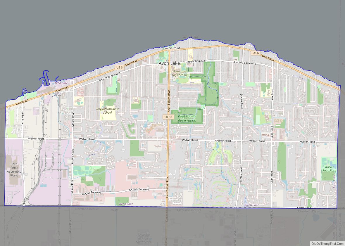
Avon Lake is a city in northeastern Lorain County, Ohio, United States, located on the southern shore of Lake Erie about 17 miles west of Cleveland. The population was 25,206 at the 2020 Census. It is part of the Cleveland metropolitan area. Avon Lake city overview: Name: Avon Lake city LSAD Code: 25 LSAD Description: … Read more

Map of Austintown CDP

Map of Austintown CDP

Austintown is an unincorporated community and census-designated place within Austintown Township, Mahoning County, Ohio, United States. The population was 29,594 at the 2020 census. Located directly west of Youngstown, it is a suburb of the Youngstown–Warren metropolitan area. Austintown CDP overview: Name: Austintown CDP LSAD Code: 57 LSAD Description: CDP (suffix) State: Ohio County: Mahoning … Read more

Map of Austinburg CDP

Map of Austinburg CDP

Austinburg is a census-designated place in northern Austinburg Township, Ashtabula County, Ohio, United States. It has a post office with the ZIP code 44010. It lies at the intersection of State Routes 45 and 307. As of the 2020 census it had a population of 505, out of a total population of 2,197 in Austinburg … Read more

Map of Batavia village, Ohio

Map of Batavia village, Ohio

Batavia (/bəˈteɪviə/ bə-TAY-vee-ə) is a village in and the county seat of Clermont County, Ohio, United States. The population was 1,972 at the 2020 census. Batavia village overview: Name: Batavia village LSAD Code: 47 LSAD Description: village (suffix) State: Ohio County: Clermont County Incorporated: February 10, 1842 Elevation: 594 ft (181 m) Total Area: 3.22 sq mi (8.35 km²) Land … Read more

Map of Bascom CDP, Ohio

Map of Bascom CDP, Ohio

Bascom (/ˈbæskəm/ BAS-kəm) is a census-designated place in western Hopewell Township, Seneca County, Ohio. It has a post office with the ZIP code 44809 and hosts Hopewell-Loudon High School. The community is located at the intersection of State Routes 18 and 635 east of Fostoria. Bascom CDP overview: Name: Bascom CDP LSAD Code: 57 LSAD … Read more

Map of Barnhill village

Map of Barnhill village

Barnhill is a village in Tuscarawas County, Ohio, United States. The population was 396 at the 2010 census. Barnhill village overview: Name: Barnhill village LSAD Code: 47 LSAD Description: village (suffix) State: Ohio County: Tuscarawas County Elevation: 876 ft (267 m) Total Area: 0.38 sq mi (0.99 km²) Land Area: 0.38 sq mi (0.99 km²) Water Area: 0.00 sq mi (0.00 km²) Total Population: 383 Population … Read more

Map of Barnesville village, Ohio

Map of Barnesville village, Ohio

Barnesville is a village in Belmont County, Ohio, United States. It is located in the central portion of Warren Township in Belmont County and is part of the Wheeling metropolitan area. The population was 4,008 at the 2020 census. Barnesville village overview: Name: Barnesville village LSAD Code: 47 LSAD Description: village (suffix) State: Ohio County: … Read more

Map of Barberton city

Map of Barberton city, Ohio

Barberton is a city in Summit County, Ohio, United States. The population was 25,191 at the 2020 census. Located directly southwest of Akron, it is a suburb of the Akron metropolitan area. Barberton city overview: Name: Barberton city LSAD Code: 25 LSAD Description: city (suffix) State: Ohio County: Summit County Elevation: 974 ft (297 m) Total Area: … Read more