Map of Allen town, Oklahoma
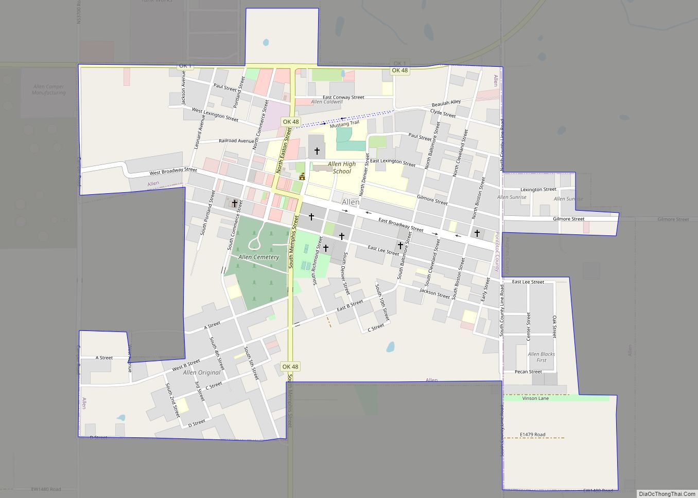
Allen is a town in Hughes and Pontotoc counties in the U.S. state of Oklahoma. The population was 932 at the 2010 census. Allen town overview: Name: Allen town LSAD Code: 43 LSAD Description: town (suffix) State: Oklahoma County: Hughes County, Pontotoc County Elevation: 869 ft (265 m) Total Area: 0.94 sq mi (2.43 km²) Land Area: 0.94 sq mi (2.43 km²) Water ... Read more
Map of Allen town, Oklahoma
Map of Aline town
Aline is a town in Alfalfa County, Oklahoma, United States. The population was 207 at the 2010 census. Aline town overview: Name: Aline town LSAD Code: 43 LSAD Description: town (suffix) State: Oklahoma County: Alfalfa County Elevation: 1,289 ft (393 m) Total Area: 0.27 sq mi (0.69 km²) Land Area: 0.27 sq mi (0.69 km²) Water Area: 0.00 sq mi (0.00 km²) Total Population: 168 Population ... Read more
Map of Aline town
Map of Arkoma town
Arkoma is a town in Le Flore County, Oklahoma, United States. It is part of the Fort Smith, Arkansas-Oklahoma Metropolitan Statistical Area. The population was 1,989 at the 2010 census, a decline from 2,180 in 2000. The name of the town is a portmanteau of Arkansas and Oklahoma. Throughout its history, Arkoma has served as ... Read more
Map of Arkoma town
Map of Ardmore city, Oklahoma
Ardmore is the county seat of Carter County, Oklahoma, United States. According to the 2010 census, the city had a population of 24,283, with an estimated population of 24,698 in 2019. The Ardmore micropolitan statistical area had an estimated population of 48,491 in 2013. Ardmore is 90 miles (140 km) from both Oklahoma City and Dallas/Fort ... Read more
Map of Ardmore city, Oklahoma
Map of Arcadia town, Oklahoma
Arcadia is a town in Oklahoma County, Oklahoma, United States, and a part of the Oklahoma City metropolitan area. The population was 247 at the 2010 census, a decrease of 11.5 percent from the figure of 279 in 2000. Arcadia town overview: Name: Arcadia town LSAD Code: 43 LSAD Description: town (suffix) State: Oklahoma County: ... Read more
Map of Arcadia town, Oklahoma
Map of Arapaho town
Arapaho is a town in, and the county seat of, Custer County, Oklahoma, United States. The population was 796 at the 2010 census, a 6.4 percent increase from the figure of 748 in 2000. The town lies long U.S. Route 183 and is named for the Arapaho Native American tribe. Arapaho town overview: Name: Arapaho ... Read more
Map of Arapaho town
Map of Atoka city, Oklahoma
Atoka is a city in and the county seat of Atoka County, Oklahoma, United States. The population was 3,107 at the 2010 census, an increase of 4.0 percent from the figure of 2,988 in 2000. As of 2021, the population has grown to 3,188. The city was settled by the Choctaw and named in 1867 ... Read more
Map of Atoka city, Oklahoma
Map of Ashland town, Oklahoma
Ashland is a town in Pittsburg County, Oklahoma, United States. The population was 66 at the 2010 census. Ashland town overview: Name: Ashland town LSAD Code: 43 LSAD Description: town (suffix) State: Oklahoma County: Pittsburg County Elevation: 774 ft (236 m) Total Area: 0.20 sq mi (0.52 km²) Land Area: 0.20 sq mi (0.51 km²) Water Area: 0.00 sq mi (0.01 km²) Total Population: 35 Population ... Read more
Map of Ashland town, Oklahoma
Map of Asher town
Asher is a town in Pottawatomie County, Oklahoma. The population was 393 at the 2010 census, a decline of 6.2 percent from the figure of 419 in 2000. Asher town overview: Name: Asher town LSAD Code: 43 LSAD Description: town (suffix) State: Oklahoma County: Pottawatomie County Elevation: 1,033 ft (315 m) Total Area: 0.77 sq mi (1.99 km²) Land Area: ... Read more
Map of Asher town
Map of Arpelar CDP
Arpelar is an unincorporated community and census-designated place in Pittsburg County, Oklahoma, United States. Its population was 291 as of the 2020 census. U.S. Route 270 and Oklahoma State Highway 1 pass through the community. Arpelar CDP overview: Name: Arpelar CDP LSAD Code: 57 LSAD Description: CDP (suffix) State: Oklahoma County: Pittsburg County Elevation: 748 ft ... Read more
Map of Arpelar CDP
Map of Arnett town
Arnett is a town in and the county seat of Ellis County, Oklahoma, United States. The population was 524 at the 2010 census, an 0.77 percent increase from 520 at the 2000 census. Arnett town overview: Name: Arnett town LSAD Code: 43 LSAD Description: town (suffix) State: Oklahoma County: Ellis County Founded: 1900 Incorporated: 1909 ... Read more
Map of Arnett town
Map of Armstrong town, Oklahoma
Armstrong is a town in Bryan County, Oklahoma, United States, along the Blue River. The population was 105 at the 2010 census, a 25.2 percent decrease from the figure of 141 recorded in 2000. The town was named for Frank C. Armstrong, a member of the Dawes Commission. Armstrong town overview: Name: Armstrong town LSAD ... Read more
Map of Armstrong town, Oklahoma