Map of Mannsville town, Oklahoma

Map of Mannsville town, Oklahoma

Mannsville is a town in Johnston County, Oklahoma, United States. The population was 863 at the 2010 census, up from 587 in 2000. Mannsville town overview: Name: Mannsville town LSAD Code: 43 LSAD Description: town (suffix) State: Oklahoma County: Johnston County Elevation: 748 ft (228 m) Total Area: 3.05 sq mi (7.91 km²) Land Area: 3.04 sq mi (7.86 km²) Water Area: 0.02 sq mi … Read more

Map of Mannford town

Map of Mannford town

Mannford is a city in Creek County in the northeastern part of the U.S. state of Oklahoma. In 2010, the population was 3,076, up from 2,095 at the 2000 census. The city sits next to Keystone Lake and claims to be the “Striped Bass Capital of the World”. Mannford town overview: Name: Mannford town LSAD … Read more

Map of Manitou town, Oklahoma

Map of Manitou town, Oklahoma

Manitou is a town in Tillman County, Oklahoma, United States. The population was 181 at the 2010 census. It includes the former town of Siboney, absorbed on January 28, 1908. [1] Manitou town overview: Name: Manitou town LSAD Code: 43 LSAD Description: town (suffix) State: Oklahoma County: Tillman County Elevation: 1,253 ft (382 m) Total Area: 0.31 sq mi … Read more

Map of Mangum city

Map of Mangum city

Mangum is a city in and county seat of Greer County, Oklahoma, United States. The population was 3,010 at the 2010 census. It was originally part of Old Greer County in the Texas panhandle. The community was named for A. S. Mangum, who owned the land on which the town was founded in 1882. It … Read more

Map of Manchester town, Oklahoma

Map of Manchester town, Oklahoma

Manchester is a town in Grant County, Oklahoma, United States. The population was 103 at the 2010 census, a decline of 1.0 percent from 104 at the 2000 census. Manchester town overview: Name: Manchester town LSAD Code: 43 LSAD Description: town (suffix) State: Oklahoma County: Grant County Elevation: 1,283 ft (391 m) Total Area: 0.24 sq mi (0.63 km²) Land … Read more

Map of Madill city

Map of Madill city

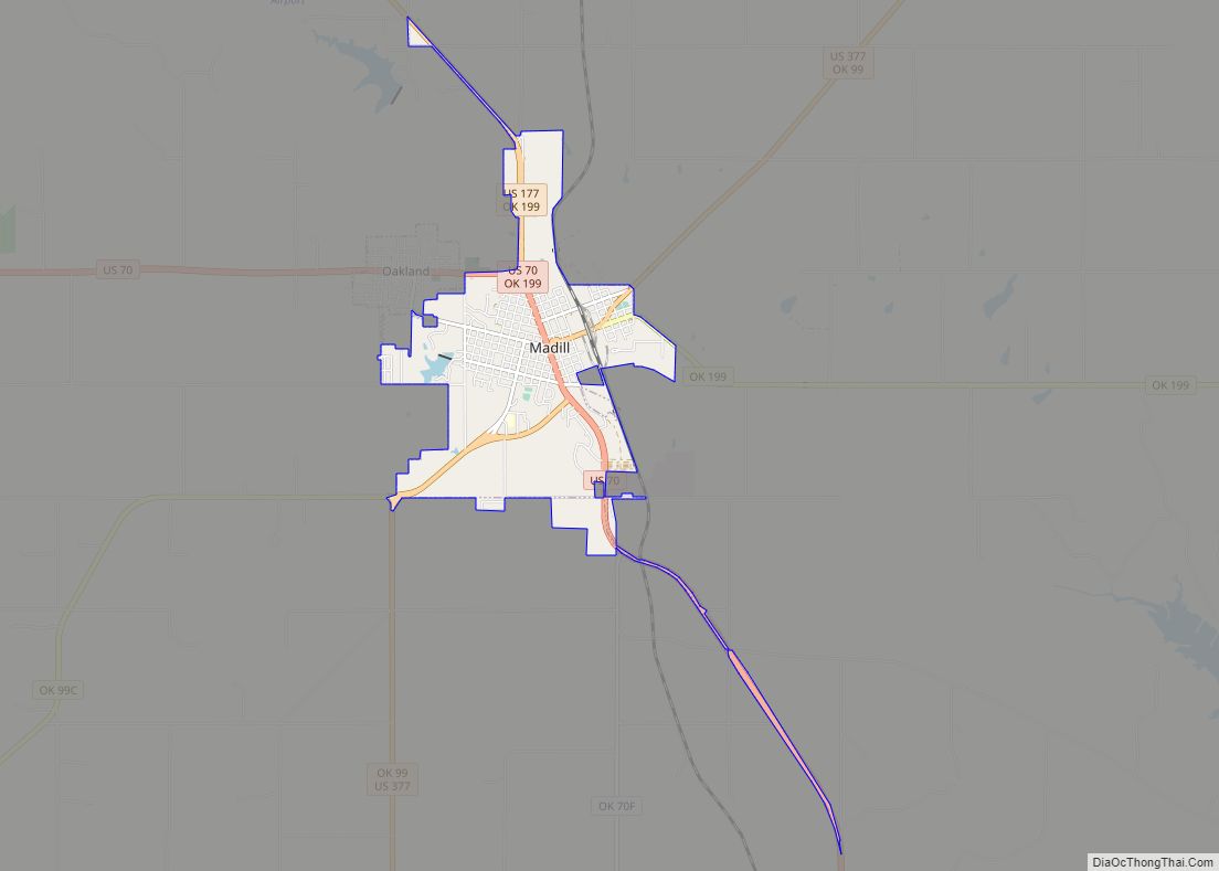
Madill is a city in and the county seat of Marshall County, Oklahoma, United States. It was named in honor of George Alexander Madill, an attorney for the St. Louis-San Francisco Railway. The population at the 2010 census was 3,770, an increase of 10.8 percent from 3,410 at the 2000 census. It is best known … Read more

Map of Macomb town, Oklahoma

Map of Macomb town, Oklahoma

Macomb is a town in Pottawatomie County, Oklahoma, United States. The population was 32 at the 2010 census, which represented a decline of 47.5 percent from the figure of 61 in 2000. Macomb town overview: Name: Macomb town LSAD Code: 43 LSAD Description: town (suffix) State: Oklahoma County: Pottawatomie County Elevation: 1,001 ft (305 m) Total Area: … Read more

Map of Lyons Switch CDP

Map of Lyons Switch CDP

Lyons Switch is a census-designated place (CDP) in Adair County, Oklahoma, United States. The population was 288 at the 2010 census. Lyons Switch CDP overview: Name: Lyons Switch CDP LSAD Code: 57 LSAD Description: CDP (suffix) State: Oklahoma County: Adair County Total Area: 13.06 sq mi (33.82 km²) Land Area: 12.70 sq mi (32.90 km²) Water Area: 0.35 sq mi (0.92 km²) Total Population: … Read more

Map of Marlow city

Map of Marlow city

Marlow is a city in Stephens County, Oklahoma, United States. The population was 4,662 at the 2010 census. Marlow city overview: Name: Marlow city LSAD Code: 25 LSAD Description: city (suffix) State: Oklahoma County: Stephens County Elevation: 1,312 ft (400 m) Total Area: 7.22 sq mi (18.70 km²) Land Area: 7.05 sq mi (18.27 km²) Water Area: 0.17 sq mi (0.43 km²) Total Population: 4,385 Population … Read more

Map of Marland town

Map of Marland town

Marland is a town in Noble County, Oklahoma, United States. The population was 225 at the 2010 census. It was named for Ernest W. Marland, an oilman from nearby Ponca City who later became a governor of Oklahoma. Marland is on SH-156, south-southwest of Ponca City. Marland town overview: Name: Marland town LSAD Code: 43 … Read more

Map of Marietta CDP, Oklahoma

Map of Marietta CDP, Oklahoma

Marietta is a census-designated place (CDP) in Adair County, Oklahoma, United States. The population was 106 at the 2010 census. The community was listed as Maryetta at the 2000 census, at which time it had a population of 138. Marietta CDP overview: Name: Marietta CDP LSAD Code: 57 LSAD Description: CDP (suffix) State: Oklahoma County: … Read more

Map of McAlester city

Map of McAlester city

McAlester is the county seat of Pittsburg County, Oklahoma. The population was 18,363 at the time of the 2010 census, a 3.4 percent increase from 17,783 at the 2000 census. The town gets its name from James Jackson McAlester, an early white settler and businessman who later became lieutenant governor of Oklahoma. Known as “J. … Read more