Map of Pump Back CDP

Map of Pump Back CDP

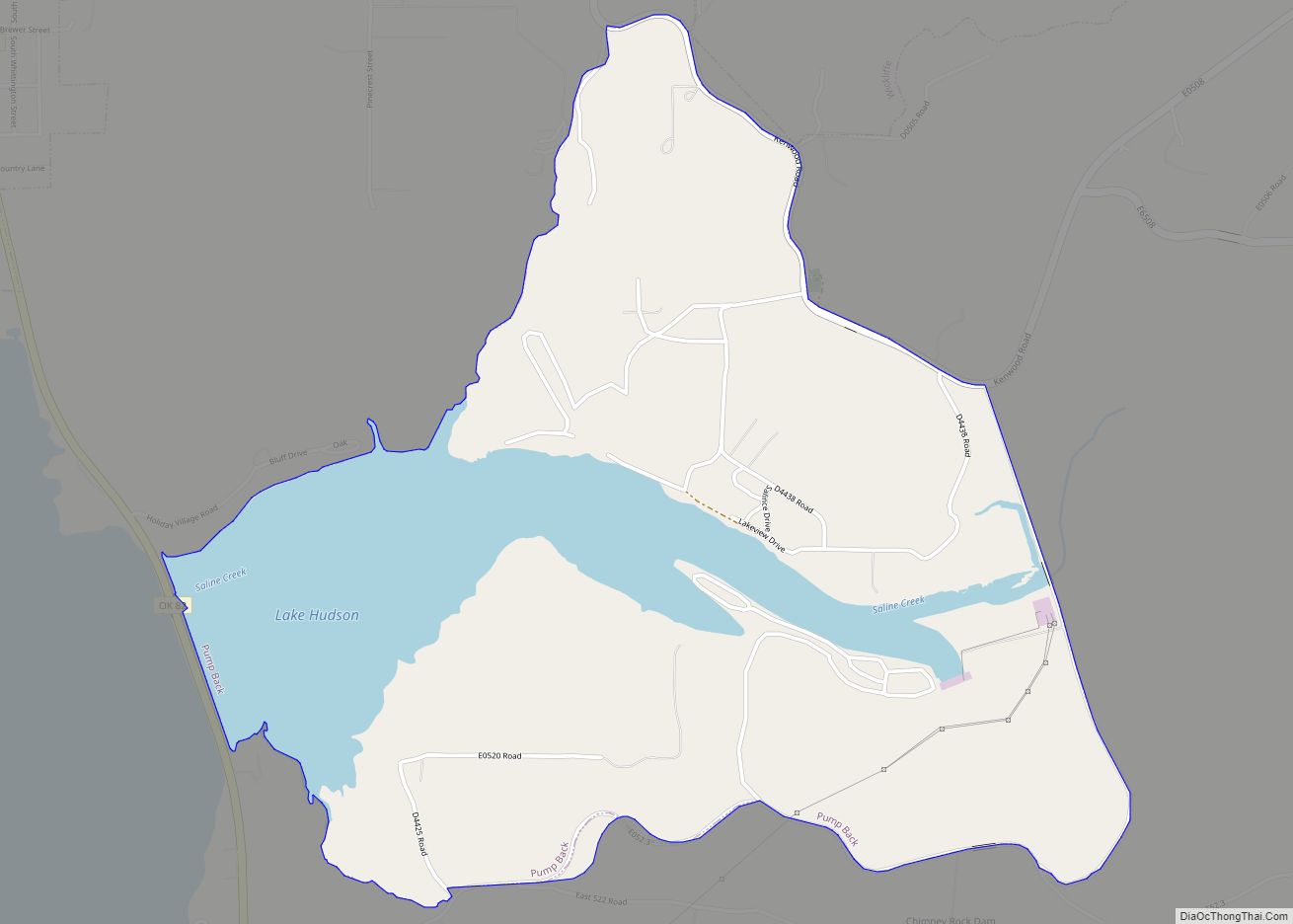
Pump Back is a census-designated place (CDP) in Mayes County, Oklahoma, United States. The population was 175 at the 2010 census compared to 155 at the 2000 census, a gain of 13 percent. Pump Back CDP overview: Name: Pump Back CDP LSAD Code: 57 LSAD Description: CDP (suffix) State: Oklahoma County: Mayes County Total Area: … Read more

Map of Pryor Creek city

Map of Pryor Creek city

Pryor Creek or Pryor is a city in and county seat of Mayes County, Oklahoma, United States. The population was 8,659 at the 2000 census and 9,539 in the 2010 census. Originally named Coo-Y-Yah, Cherokee for “place of the huckleberries”, it was renamed Pryor Creek in 1887 which was the name of the local railroad … Read more

Map of Prue town

Map of Prue town

Prue is a town in southern Osage County, Oklahoma, United States. The population was 465 at the 2010 census, up 7.4 percent from the figure of 433 recorded in 2000. The town was named for Henry Prue, who owned the original townsite. Prue was relocated when Lake Keystone was built, and is sometimes called “New … Read more

Map of Proctor CDP, Oklahoma

Map of Proctor CDP, Oklahoma

Proctor is a census-designated place (CDP) in Adair County, Oklahoma, United States. The population was 231 at the 2010 census. Proctor CDP overview: Name: Proctor CDP LSAD Code: 57 LSAD Description: CDP (suffix) State: Oklahoma County: Adair County Elevation: 820 ft (250 m) Total Area: 10.80 sq mi (27.97 km²) Land Area: 10.71 sq mi (27.73 km²) Water Area: 0.09 sq mi (0.23 km²) Total Population: … Read more

Map of Prague city, Oklahoma

Map of Prague city, Oklahoma

Prague (/ˈpreɪɡ/) is a city in Lincoln County, Oklahoma, United States. The population was 2,346 at the 2020 census, an 1.76 percent decrease from the figure of 2,388 in 2010. Czech immigrants founded the city, and named it after the capital of the present-day Czech Republic. Prague city overview: Name: Prague city LSAD Code: 25 … Read more

Map of Poteau city

Map of Poteau city

Poteau (/ˈpoʊtoʊ/ POH-toh) is a city in, and county seat of, Le Flore County, Oklahoma, United States. The population was 8,520 as of the 2010 census. Poteau city overview: Name: Poteau city LSAD Code: 25 LSAD Description: city (suffix) State: Oklahoma County: Le Flore County Elevation: 489 ft (149 m) Total Area: 28.73 sq mi (74.40 km²) Land Area: 26.61 sq mi … Read more

Map of Porum town

Map of Porum town

Porum is a town in Muskogee County, Oklahoma, United States. It was named for John Porum Davis, a rancher, Civil War veteran, and Cherokee Nation councilman from the Canadian District in Indian Territory. The community was first known as Porum Gap, which united with another village named Starvilla in 1905. The product of this union … Read more

Map of Porter town, Oklahoma

Map of Porter town, Oklahoma

Porter is a town in Wagoner County, Oklahoma, United States. It promotes itself as “The Peach Capital of Oklahoma.” The population was 566 at the 2010 census, a loss of 1.4 percent, compared to 574 at the 2000 census. Porter town overview: Name: Porter town LSAD Code: 43 LSAD Description: town (suffix) State: Oklahoma County: … Read more

Map of Quinton town, Oklahoma

Map of Quinton town, Oklahoma

Quinton is a town in Pittsburg County, Oklahoma, United States. The population was 1,051 at the 2010 census. The town was named for Elizabeth Quinton, who lived to be 116 years old. Her family still resides in and around the town of Quinton. Quinton town overview: Name: Quinton town LSAD Code: 43 LSAD Description: town … Read more

Map of Quapaw town

Map of Quapaw town

Quapaw is a town in Ottawa County, Oklahoma, United States. Its population was 906 at the 2010 census, a 7.9% decline from the 984 recorded in 2000. Quapaw is part of the Joplin, Missouri metropolitan area. Quapaw town overview: Name: Quapaw town LSAD Code: 43 LSAD Description: town (suffix) State: Oklahoma County: Ottawa County Elevation: … Read more

Map of Red Rock town, Oklahoma

Map of Red Rock town, Oklahoma

Red Rock (Iowa-Oto: Chína Ino Šúje pronounced ĩꜜno suꜜdʒɛ, meaning “Rock Red town”) is a town in northern Noble County, Oklahoma, United States. The population was 283 at the 2010 census, a decline from 293 at the 2000 census. The headquarters of the Otoe-Missouria Tribe of Indians is located in Red Rock. Red Rock town … Read more

Map of Red Oak town, Oklahoma

Map of Red Oak town, Oklahoma

Red Oak is a town in Latimer County, Oklahoma, United States. The population was 549 at the 2010 census. Eight miles northeast of the present town is the original site of Red Oak. There in 1850 Thomas Edwards established a trading post on the Fort Smith–Boggy Depot Road. With the advent of the Butterfield Overland … Read more