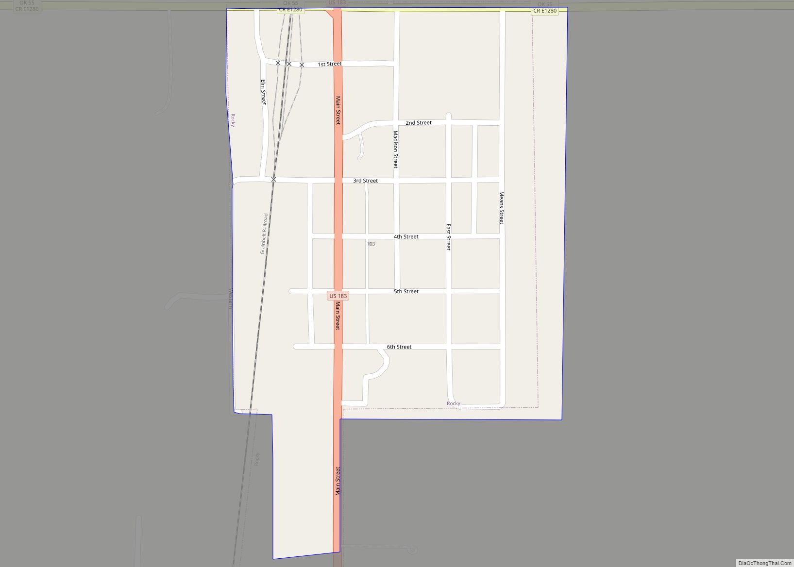
Map of Rose CDP

Map of Rose CDP

Rose is a small unincorporated rural community and census-designated place in southeastern Mayes County, Oklahoma, United States, on Scenic U.S. Highway 412. The community was said to have been named for Rowe’s Prairie, which is nearby. The post office was established March 13, 1891, with David Ragsdale as the postmaster. The ZIP Code is 74364. … Read more

Map of Roosevelt town, Oklahoma

Map of Roosevelt town, Oklahoma

Roosevelt is a town in Kiowa County, Oklahoma, United States. The population was 248 at the 2010 census, a decline of 11.4 percent from 283 in 2000. The town was named for President Theodore Roosevelt. Roosevelt town overview: Name: Roosevelt town LSAD Code: 43 LSAD Description: town (suffix) State: Oklahoma County: Kiowa County Elevation: 1,463 ft … Read more

Map of Sasakwa town

Map of Sasakwa town

Sasakwa is a town in Seminole County, Oklahoma, United States. The population was documented as 150 in both the 2010 and 2000 census. Sasakwa town overview: Name: Sasakwa town LSAD Code: 43 LSAD Description: town (suffix) State: Oklahoma County: Seminole County Elevation: 843 ft (257 m) Total Area: 0.21 sq mi (0.55 km²) Land Area: 0.21 sq mi (0.55 km²) Water Area: 0.00 sq mi … Read more

Map of Sapulpa city

Map of Sapulpa city

Sapulpa is a city in Creek and Tulsa counties in the U.S. state of Oklahoma. The population was 20,544 at the 2010 United States census, compared to 19,166 at the 2000 census. The population as of 2022 is 22,205. As of 2019, the estimated population was 21,278. It is the county seat of Creek County. … Read more

Map of Sand Springs city

Map of Sand Springs city, Oklahoma

Sand Springs is a city in Osage, Creek and Tulsa counties in the U.S. state of Oklahoma. A western suburb of Tulsa, it is located predominantly in Tulsa County. The population was 19,874 in the 2020 U. S. Census, an increase of 5.1 percent from the figure of 18,906 recorded in 2010. Sand Springs city … Read more

Map of Sand Hill CDP

Map of Sand Hill CDP, Oklahoma

Sand Hills is a census-designated place (CDP) in Muskogee County, Oklahoma, United States. The population was 422 at the 2000 census. Sand Hill CDP overview: Name: Sand Hill CDP LSAD Code: 57 LSAD Description: CDP (suffix) State: Oklahoma County: Muskogee County Total Area: 7.60 sq mi (19.69 km²) Land Area: 7.60 sq mi (19.69 km²) Water Area: 0.00 sq mi (0.00 km²) Total Population: … Read more

Map of Sams Corner CDP

Map of Sams Corner CDP

Sams Corner is a census-designated place (CDP) in Mayes County, Oklahoma, United States. The population was 137 at the 2010 census, compared to 126 at the 2000 census. Sams Corner CDP overview: Name: Sams Corner CDP LSAD Code: 57 LSAD Description: CDP (suffix) State: Oklahoma County: Mayes County Total Area: 0.96 sq mi (2.49 km²) Land Area: 0.96 sq mi … Read more

Map of Sallisaw city

Map of Sallisaw city

Sallisaw is a city and county seat in Sequoyah County, Oklahoma, United States. As of the 2010 Census, it had a population of 8,880, an 11.2 percent increase over the figure of 7,891 recorded in 2000. Sallisaw is part of the Fort Smith, Arkansas–Oklahoma Metropolitan Statistical Area. Sallisaw city overview: Name: Sallisaw city LSAD Code: … Read more

Map of Salina town, Oklahoma

Map of Salina town, Oklahoma

Salina (/səˈlaɪnə/ sə-LY-nə) is a town in Mayes County, Oklahoma, United States. The population was 1,396 at the 2010 census, a slight decline from the figure of 1,422 recorded in 2000. Salina town overview: Name: Salina town LSAD Code: 43 LSAD Description: town (suffix) State: Oklahoma County: Mayes County Elevation: 640 ft (195 m) Total Area: 1.18 sq mi … Read more

Map of Salem CDP, Oklahoma

Map of Salem CDP, Oklahoma

Salem is a census-designated place (CDP) in Adair County, Oklahoma, United States. The population was 112 at the 2010 census. Salem CDP overview: Name: Salem CDP LSAD Code: 57 LSAD Description: CDP (suffix) State: Oklahoma County: Adair County Elevation: 1,286 ft (392 m) Total Area: 3.3 sq mi (8.6 km²) Land Area: 3.3 sq mi (8.6 km²) Water Area: 0.0 sq mi (0.0 km²) Total Population: … Read more

Map of Ryan town, Oklahoma

Map of Ryan town, Oklahoma

Ryan is a town in Jefferson County, Oklahoma, United States, located north of the Texas state line. The population was 816 at the 2010 census, a decline of over 8.7 percent from the figure of 894 in 2000. Ryan town overview: Name: Ryan town LSAD Code: 43 LSAD Description: town (suffix) State: Oklahoma County: Jefferson … Read more

Map of Rush Springs town

Map of Rush Springs town

Rush Springs is a town in Grady County, Oklahoma, United States. The population was 997 at the 2020 census, a 19% decrease form 2010. The town promotes itself as the “Watermelon Capital of the World.” The community’s largest event is the annual Rush Springs Watermelon Festival, which attracts about 30,000 people each year. They consume … Read more