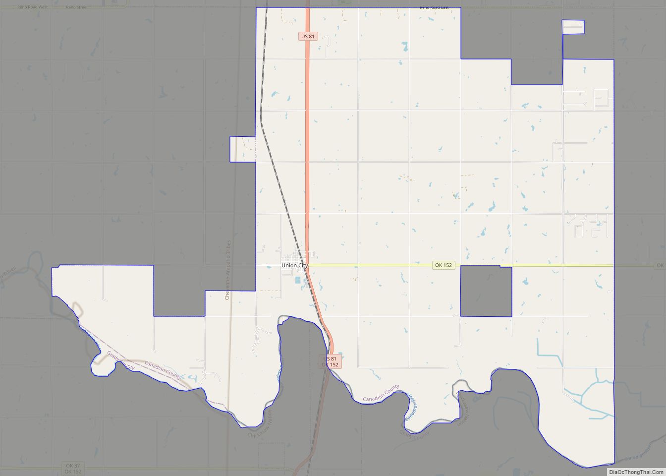
Map of Twin Oaks CDP, Oklahoma

Map of Twin Oaks CDP, Oklahoma

Twin Oaks is an unincorporated community and census-designated place (CDP) in Delaware County, Oklahoma, United States. The population was 198 at the 2010 census. A tornado hit the town on March 12, 2006, destroying 36 homes and damaging 31 others. 8 people were injured. Twin Oaks CDP overview: Name: Twin Oaks CDP LSAD Code: 57 … Read more

Map of Tuttle city, Oklahoma

Map of Tuttle city, Oklahoma

Tuttle is a city in Grady County, Oklahoma, United States. The population was 7,413 with the close of the 2020 census, seeing a 23.2% increase from 6,010 in 2010. Tuttle city overview: Name: Tuttle city LSAD Code: 25 LSAD Description: city (suffix) State: Oklahoma County: Grady County Elevation: 1,319 ft (402 m) Total Area: 29.49 sq mi (76.37 km²) Land … Read more

Map of Tuskahoma CDP

Map of Tuskahoma CDP

Tuskahoma is an unincorporated community and census-designated place in northern Pushmataha County, Oklahoma, United States, four miles east of Clayton. It was the former seat of the Choctaw Nation government prior to Oklahoma statehood. The population at the 2010 census was 151. Tuskahoma CDP overview: Name: Tuskahoma CDP LSAD Code: 57 LSAD Description: CDP (suffix) … Read more

Map of Tushka town

Map of Tushka town

Tushka is a town in Atoka County, Oklahoma, United States. The population was 312 at the 2010 census, a decline of 9.6 percent from the figure of 345 recorded in 2000. Tushka town overview: Name: Tushka town LSAD Code: 43 LSAD Description: town (suffix) State: Oklahoma County: Atoka County Elevation: 623 ft (190 m) Total Area: 0.76 sq mi … Read more

Map of Vinita city

Map of Vinita city

Vinita is a city and county seat of Craig County, Oklahoma, United States. As of the 2010 census, the population was 5,743, a decline of 11.22 percent from the figure of 6,469 recorded in 2000. Vinita city overview: Name: Vinita city LSAD Code: 25 LSAD Description: city (suffix) State: Oklahoma County: Craig County Founded: 1870 … Read more

Map of Vici town

Map of Vici town

Vici /ˈvaɪsaɪ/ is a town in Dewey County, Oklahoma, United States. The population was 699 at the 2010 census. No information appears on the origins of the town name, but Vici is Latin for “I conquered.” Vici town overview: Name: Vici town LSAD Code: 43 LSAD Description: town (suffix) State: Oklahoma County: Dewey County Elevation: … Read more

Map of Vian town

Map of Vian town

Vian (Cherokee: ᏓᏄᎪᎢ, romanized: da-hnu-go-i, lit. ‘gar-place’) is a town in Sequoyah County, Oklahoma, United States, adjacent to Interstate 40 at the intersection of U.S. Route 64 and Oklahoma State Highway 82. The population was 1,374 at the 2020 census, a 6.3 percent decline from the figure of 1,466 recorded in 2010. It is part of the … Read more

Map of Verdigris town

Map of Verdigris town

Verdigris is an incorporated town in Rogers County, Oklahoma, United States, in the Tulsa metropolitan area. It straddles former U.S. Highway 66 (now State Highway 66) between Catoosa and Claremore. Verdigris had a population of 3,993 at the 2010 census, an increase of 92.9 percent from 2,070 at the 2000 census. Verdigris town overview: Name: … Read more

Map of Verden town

Map of Verden town

Verden is a town in western Grady County, Oklahoma, United States. It abuts the Caddo County line, and is probably best known as the site of the 1865 Camp Napoleon Council. The population was 580 at the 2020 census, a decline from 530 in 2010. Verden town overview: Name: Verden town LSAD Code: 43 LSAD … Read more

Map of Vera town

Map of Vera town

Vera is a town in Washington County, Oklahoma, United States. The population was 334 as of the 2020 census. Vera town overview: Name: Vera town LSAD Code: 43 LSAD Description: town (suffix) State: Oklahoma County: Washington County Elevation: 640 ft (200 m) Total Area: 0.79 sq mi (2.05 km²) Land Area: 0.79 sq mi (2.05 km²) Water Area: 0.00 sq mi (0.00 km²) Total Population: 334 … Read more

Map of Walters city, Oklahoma

Map of Walters city, Oklahoma

Walters is a town in Cotton County, Oklahoma, United States. The population was 2,551 at the 2010 census. The city, nestled between twin creeks, is the county seat of Cotton County. The city’s motto is “Small town; Big heart.” Walters city overview: Name: Walters city LSAD Code: 25 LSAD Description: city (suffix) State: Oklahoma County: … Read more

Map of Wakita town

Map of Wakita town

Wakita is a town in Grant County, Oklahoma, United States, founded in 1898, approximately 8 miles (13 km) south of the Kansas border. Its population was 344 at the 2010 census, a decrease of 18.1 percent (from 420) at the 2000 census. Wakita is notable as a location in the 1996 feature film Twister. Wakita town … Read more