Map of Mosier city

Map of Mosier city

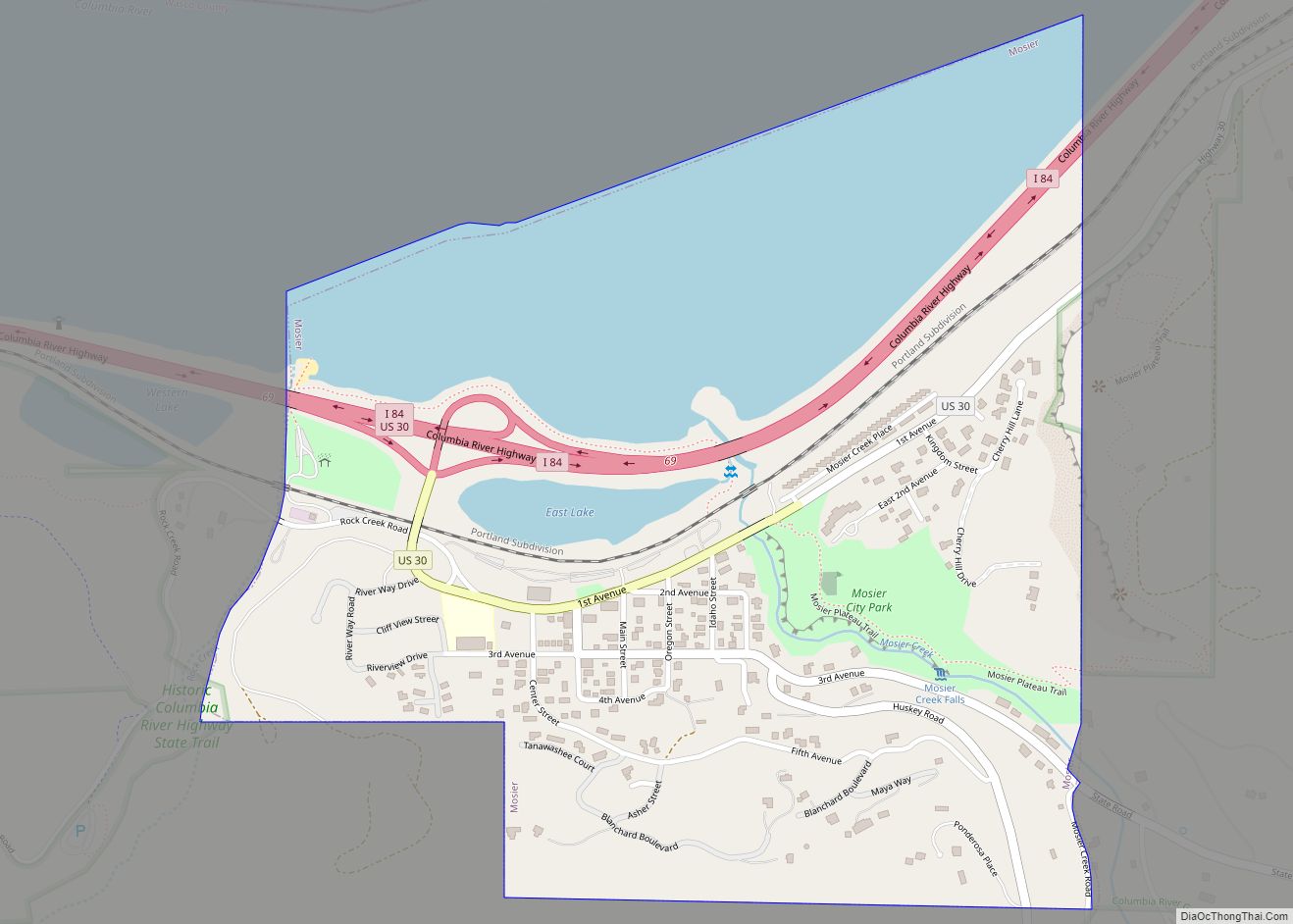
Mosier is a city along the Columbia River in Wasco County, Oregon, United States. The population was 433 at the 2010 census. Mosier city overview: Name: Mosier city LSAD Code: 25 LSAD Description: city (suffix) State: Oregon County: Wasco County Incorporated: 1914 Elevation: 164 ft (50 m) Total Area: 0.63 sq mi (1.64 km²) Land Area: 0.46 sq mi (1.18 km²) Water Area: … Read more

Map of Moro city, Oregon

Map of Moro city, Oregon

Moro is a city in Sherman County, Oregon, United States. The population was 324 at the 2010 census. It is the county seat of Sherman County It’s currently the least-populous county seat in Oregon. Moro was incorporated on February 17, 1899, by the Oregon Legislative Assembly. It was named for Moro, Illinois. Moro city overview: … Read more

Map of Monument city, Oregon

Map of Monument city, Oregon

Monument is a city in Grant County, Oregon, United States. The population was 128 at the 2010 census. It is located near the confluence of the North and Middle Forks of the John Day River. Its post office was established in 1874 and named for a nearby mountain or rock formation. As of 2000, the … Read more

Map of Monroe city, Oregon

Map of Monroe city, Oregon

Monroe is a city in Benton County, Oregon, United States. The population was 651 at the 2018 census. It is part of the Corvallis, Oregon Metropolitan Statistical Area. Monroe is located midway between Eugene and Corvallis along Highway 99W and the city experiences a strong friendly rivalry between fans of the Oregon Ducks and the … Read more

Map of Monmouth city, Oregon

Map of Monmouth city, Oregon

Monmouth (/ˈmɒnməθ/) is a city in Polk County in the U.S. state of Oregon. It was named for Monmouth, Illinois, the origin of its earliest settlers. The population is 11,110 at the 2020 Census and it is part of the Salem Metropolitan Statistical Area. Monmouth city overview: Name: Monmouth city LSAD Code: 25 LSAD Description: … Read more

Map of Molalla city

Map of Molalla city

Molalla /məˈlɑːlə/ is a city in Clackamas County, Oregon. The population was 10,228 at the time of the 2020 census. Molalla city overview: Name: Molalla city LSAD Code: 25 LSAD Description: city (suffix) State: Oregon County: Clackamas County Incorporated: 1913 Elevation: 371 ft (113 m) Total Area: 2.53 sq mi (6.55 km²) Land Area: 2.48 sq mi (6.42 km²) Water Area: 0.05 sq mi (0.12 km²) … Read more

Map of Mitchell city, Oregon

Map of Mitchell city, Oregon

Mitchell is a city in Wheeler County, Oregon, United States. The population was 130 at the 2010 census. It was founded in 1873 and was named after John H. Mitchell, a politician. The Painted Hills unit of the John Day Fossil Beds National Monument is about 9 miles (14 km) northwest of Mitchell. Mitchell School, a … Read more

Map of Mission CDP, Oregon

Map of Mission CDP, Oregon

Mission is an unincorporated community in Umatilla County, Oregon, United States. For statistical purposes, the United States Census Bureau has defined Mission as a census-designated place (CDP). The census definition of the area may not precisely correspond to local understanding of the area with the same name. The population was 1,019 at the 2000 census. … Read more

Map of Myrtle Creek city

Map of Myrtle Creek city

Myrtle Creek is a city in Douglas County, Oregon, United States. The population was 3,439 at the 2010 census. Myrtle Creek city overview: Name: Myrtle Creek city LSAD Code: 25 LSAD Description: city (suffix) State: Oregon County: Douglas County Incorporated: 1893 Elevation: 610 ft (190 m) Total Area: 2.50 sq mi (6.47 km²) Land Area: 2.50 sq mi (6.47 km²) Water Area: 0.00 sq mi … Read more

Map of Mulino CDP

Map of Mulino CDP

Mulino, Oregon is a hamlet and census-designated place (CDP) located in Clackamas County, Oregon, United States, on Oregon Route 213 between the cities of Oregon City and Molalla. As of the 2010 census it had a population of 2,103. Mulino CDP overview: Name: Mulino CDP LSAD Code: 57 LSAD Description: CDP (suffix) State: Oregon County: … Read more

Map of Mount Vernon city, Oregon

Map of Mount Vernon city, Oregon

Mount Vernon is a city in Grant County, Oregon, United States. Its post office was established in 1877 and named after a black stallion that belonged to settler David W. Jenkins. The stallion’s stable, a small stone building, is still standing in a field on the north side of U.S. Highway 26 about 2.2 miles … Read more

Map of Mount Hood CDP

Map of Mount Hood CDP

Mount Hood is an unincorporated community and census-designated place (CDP) in Hood River County, Oregon, United States, about 3 miles (5 km) northeast of Parkdale on Oregon Route 35. As of the 2010 census it had a population of 286. Mount Hood is the terminus of Oregon Route 281, the Hood River Highway. The community was … Read more