Map of Lupton CDP, Michigan
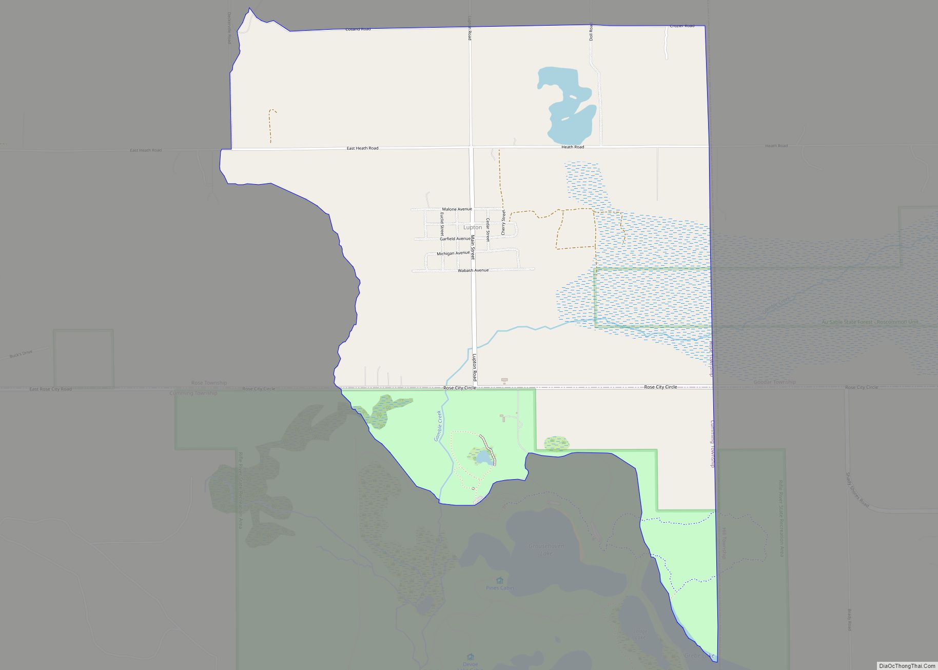
Lupton is an unincorporated community and census-designated place (CDP) in Ogemaw County in the U.S. state of Michigan. At the 2010 census, it had a population of 348. Lupton is located mostly within Rose Township with a small portion extending south into Cumming Township. Lupton CDP overview: Name: Lupton CDP LSAD Code: 57 LSAD Description: ... Read more
Map of Lupton CDP, Michigan
Map of Mackinaw City village
Mackinaw City (/ˈmækənɔː/ MAK-ə-naw) is a village at the northernmost point of the Lower Peninsula of Michigan. Divided between Cheboygan and Emmet counties, Mackinaw City is the located at the southern end of the Mackinac Bridge, which carries Interstate 75 over the Straits of Mackinac to the Upper Peninsula. Mackinaw City, along with St. Ignace, ... Read more
Map of Mackinaw City village
Map of Manistee city
Manistee (/mænɪsti/ man-iss-TEE) is a city in the U.S. state of Michigan. Located in southwestern Manistee County, it is part of the northwestern Lower Peninsula. Manistee is the county seat of Manistee County, and its population was 6,259 at the 2020 census. This makes Manistee the fifth-largest city in Northern Michigan. Manistee is located on ... Read more
Map of Manistee city
Map of Manistee Lake CDP
Manistee Lake is an unincorporated community and census-designated place (CDP) in Kalkaska County in the U.S. state of Michigan. At the 2010 census, the CDP had a population of 456. Manistee Lake is located within Coldsprings Township to the north and a small portion extending south into Excelsior Township. Manistee Lake CDP overview: Name: Manistee ... Read more
Map of Manistee Lake CDP
Map of Manchester village, Michigan
Manchester is a village in Manchester Township within Washtenaw County in the U.S. state of Michigan. The population was 2,037 at the 2020 census. Manchester village overview: Name: Manchester village LSAD Code: 47 LSAD Description: village (suffix) State: Michigan County: Washtenaw County Incorporated: 1867 Elevation: 899 ft (274 m) Total Area: 2.24 sq mi (5.81 km²) Land Area: 2.13 sq mi (5.51 km²) ... Read more
Map of Manchester village, Michigan
Map of Mancelona village
Mancelona (/mænˌsəˈloʊnə/ man-sə-LOW-nə) is a village in the Northern Lower Peninsula of the U.S. state of Michigan. Part of Mancelona Township, the village is located within Antrim County. Its population was 1,344 at the 2020 census. Mancelona village overview: Name: Mancelona village LSAD Code: 47 LSAD Description: village (suffix) State: Michigan County: Antrim County Incorporated: ... Read more
Map of Mancelona village
Map of Madison Heights city, Michigan
Madison Heights is a city in Oakland County in the U.S. state of Michigan. As of the 2010 census, its population was 29,694. It is a northern suburb of Metro Detroit, about 2 miles (3.2 km) north of the Detroit city limits. Madison Heights city overview: Name: Madison Heights city LSAD Code: 25 LSAD Description: city ... Read more
Map of Madison Heights city, Michigan
Map of Maple Grove CDP, Michigan
Maple Grove is an unincorporated community and census-designated place in Benzie County in the U.S. state of Michigan. The population was 132 at the 2010 census. Maple Grove is located within Almira Township. Maple Grove CDP overview: Name: Maple Grove CDP LSAD Code: 57 LSAD Description: CDP (suffix) State: Michigan County: Benzie County Elevation: 820 ft ... Read more
Map of Maple Grove CDP, Michigan
Map of Maple City CDP
Maple City is an unincorporated community and census-designated place in Leelanau County in the U.S. state of Michigan. The population of Maple City was 209 at the 2020 census. Cedar is located within Kasson Township, and lies about 13 miles (21 km) northwest of Traverse City. As an unincorporated community, Maple City holds no legal autonomy ... Read more
Map of Maple City CDP
Map of Manton city, Michigan
Manton is a city in Wexford County in the U.S. state of Michigan. The population was 1,258 at the 2020 census. Manton city overview: Name: Manton city LSAD Code: 25 LSAD Description: city (suffix) State: Michigan County: Wexford County Incorporated: 1877 (village)1923 (city) Elevation: 1,132 ft (345 m) Total Area: 1.61 sq mi (4.18 km²) Land Area: 1.56 sq mi (4.04 km²) Water ... Read more
Map of Manton city, Michigan
Map of Manitou Beach-Devils Lake CDP
Manitou Beach-Devils Lake CDP overview: Name: Manitou Beach-Devils Lake CDP LSAD Code: 57 LSAD Description: CDP (suffix) State: Michigan County: Lenawee County FIPS code: 2650830 Online Interactive Map Manitou Beach-Devils Lake online map. Source: Basemap layers from Google Map, Open Street Map (OSM), Arcgisonline, Wmflabs. Boundary Data from Database of Global Administrative Areas. Manitou Beach-Devils ... Read more
Map of Manitou Beach-Devils Lake CDP
Map of Manistique city
Manistique (/mænɪstik/ man-iss-TEEK) is the only city and county seat of Schoolcraft County in the U.S. state of Michigan. As of the 2020 census, the city population was 2,828. The city borders the adjacent Manistique Township, but the two are administered independently. The city lies on the north shore of Lake Michigan at the mouth ... Read more
Map of Manistique city