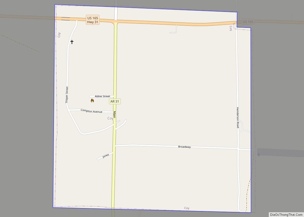
Map of Cove town, Arkansas
Cove is a town in Polk County, Arkansas, United States. The population was 382 at the 2010 census. Cove town overview: Name: Cove town LSAD Code: 43 LSAD Description: town (suffix) State: Arkansas County: Polk County Elevation: 1,102 ft (336 m) Total Area: 1.62 sq mi (4.20 km²) Land Area: 1.60 sq mi (4.14 km²) Water Area: 0.02 sq mi (0.06 km²) Total Population: 319 Population ... Read more
Map of Cove town, Arkansas
Map of Cotton Plant city
Cotton Plant is a city in southern Woodruff County, Arkansas, United States. As of the 2020 census, the city had a total population of 529. Cotton Plant city overview: Name: Cotton Plant city LSAD Code: 25 LSAD Description: city (suffix) State: Arkansas County: Woodruff County Incorporated: November 14, 1887 Elevation: 194 ft (59 m) Total Area: 1.04 sq mi ... Read more
Map of Cotton Plant city
Map of Cushman city
Cushman is a city in Independence County, Arkansas, United States. The population was 433 at the 2020 census. Cushman city overview: Name: Cushman city LSAD Code: 25 LSAD Description: city (suffix) State: Arkansas County: Independence County Elevation: 702 ft (214 m) Total Area: 4.08 sq mi (10.56 km²) Land Area: 4.08 sq mi (10.56 km²) Water Area: 0.00 sq mi (0.00 km²) Total Population: 433 Population ... Read more
Map of Cushman city
Map of Crossett city
Crossett is the largest city in Ashley County, Arkansas, United States, with a population of 5,507, according to 2010 Census Bureau estimates. Combined with North Crossett and West Crossett, the population is 10,752. Crossett was incorporated in 1903. There are four properties on Main Street in Crossett listed on the National Register of Historic Places, ... Read more
Map of Crossett city
Map of Crawfordsville town, Arkansas
Crawfordsville, historically Crawfordville, is a town in Crittenden County, Arkansas, United States. The population was 479 at the 2010 census. Crawfordsville town overview: Name: Crawfordsville town LSAD Code: 43 LSAD Description: town (suffix) State: Arkansas County: Crittenden County Elevation: 220 ft (67 m) Total Area: 0.56 sq mi (1.45 km²) Land Area: 0.56 sq mi (1.45 km²) Water Area: 0.00 sq mi (0.00 km²) Total Population: ... Read more
Map of Crawfordsville town, Arkansas
Map of Danville city, Arkansas
Danville is a city in Yell County, Arkansas, United States. The population was 2,409 at the 2010 census. Along with Dardanelle, it is one of two county seats for Yell County. Danville is part of the Russellville Micropolitan Statistical Area. Danville city overview: Name: Danville city LSAD Code: 25 LSAD Description: city (suffix) State: Arkansas ... Read more
Map of Danville city, Arkansas
Map of Damascus town, Arkansas
Damascus is a town in Faulkner and Van Buren counties of central Arkansas, United States. The population of Damascus was 382 at the 2010 census. Damascus town overview: Name: Damascus town LSAD Code: 43 LSAD Description: town (suffix) State: Arkansas County: Faulkner County, Van Buren County Incorporated: July 15, 1966 Elevation: 696 ft (212 m) Total Area: ... Read more
Map of Damascus town, Arkansas
Map of Daisy town, Arkansas
Daisy is a town in Pike County, Arkansas, United States. Its population is 88 as of the 2020 census. Daisy is also the home of Daisy State Park. Daisy town overview: Name: Daisy town LSAD Code: 43 LSAD Description: town (suffix) State: Arkansas County: Pike County Elevation: 620 ft (189 m) Total Area: 1.45 sq mi (3.76 km²) Land Area: ... Read more
Map of Daisy town, Arkansas
Map of De Queen city
De Queen (/diː kwiːn/ DEE-kween) is a city and the county seat of Sevier County, Arkansas, United States. The population was 6,629 at the 2010 census. The placename is the anglicization of the family name of the Dutch merchant and railway financier, Jan de Goeijen (1861–1944). De Goeijen was reportedly rather unhappy with the deformation ... Read more
Map of De Queen city
Map of Datto town
Datto is a town in Clay County, Arkansas, United States. The population was 100 at the 2010 census. Datto town overview: Name: Datto town LSAD Code: 43 LSAD Description: town (suffix) State: Arkansas County: Clay County Elevation: 289 ft (88 m) Total Area: 0.62 sq mi (1.61 km²) Total Population: 65 Population Density: 104.67/sq mi (40.42/km²) ZIP code: 72424 Area code: ... Read more
Map of Datto town
Map of Dardanelle city
Dardanelle is a city in northeast Yell County, Arkansas, United States. The population was 4,745 at the 2010 census. Along with Danville, it serves as a county seat for Yell County. It is located near Lake Dardanelle. Dardanelle is part of the Russellville Micropolitan Statistical Area. Dardanelle city overview: Name: Dardanelle city LSAD Code: 25 ... Read more
Map of Dardanelle city
Map of Delaplaine town
Delaplaine is a town in Greene County, Arkansas, United States. The population was 116 at the time of the 2010 census. Delaplaine town overview: Name: Delaplaine town LSAD Code: 43 LSAD Description: town (suffix) State: Arkansas County: Greene County Elevation: 279 ft (85 m) Total Area: 1.11 sq mi (2.86 km²) Land Area: 1.11 sq mi (2.86 km²) Water Area: 0.00 sq mi (0.00 km²) Total ... Read more
Map of Delaplaine town