Dardanelle is a city in northeast Yell County, Arkansas, United States. The population was 4,745 at the 2010 census. Along with Danville, it serves as a county seat for Yell County. It is located near Lake Dardanelle.
Dardanelle is part of the Russellville Micropolitan Statistical Area.
| Name: | Dardanelle city |
|---|---|
| LSAD Code: | 25 |
| LSAD Description: | city (suffix) |
| State: | Arkansas |
| County: | Yell County |
| Elevation: | 335 ft (102 m) |
| Total Area: | 3.64 sq mi (9.44 km²) |
| Land Area: | 3.64 sq mi (9.44 km²) |
| Water Area: | 0.00 sq mi (0.00 km²) |
| Total Population: | 4,517 |
| Population Density: | 1,239.57/sq mi (478.56/km²) |
| ZIP code: | 72834 |
| Area code: | 479 |
| FIPS code: | 0517380 |
| GNISfeature ID: | 0079131 |
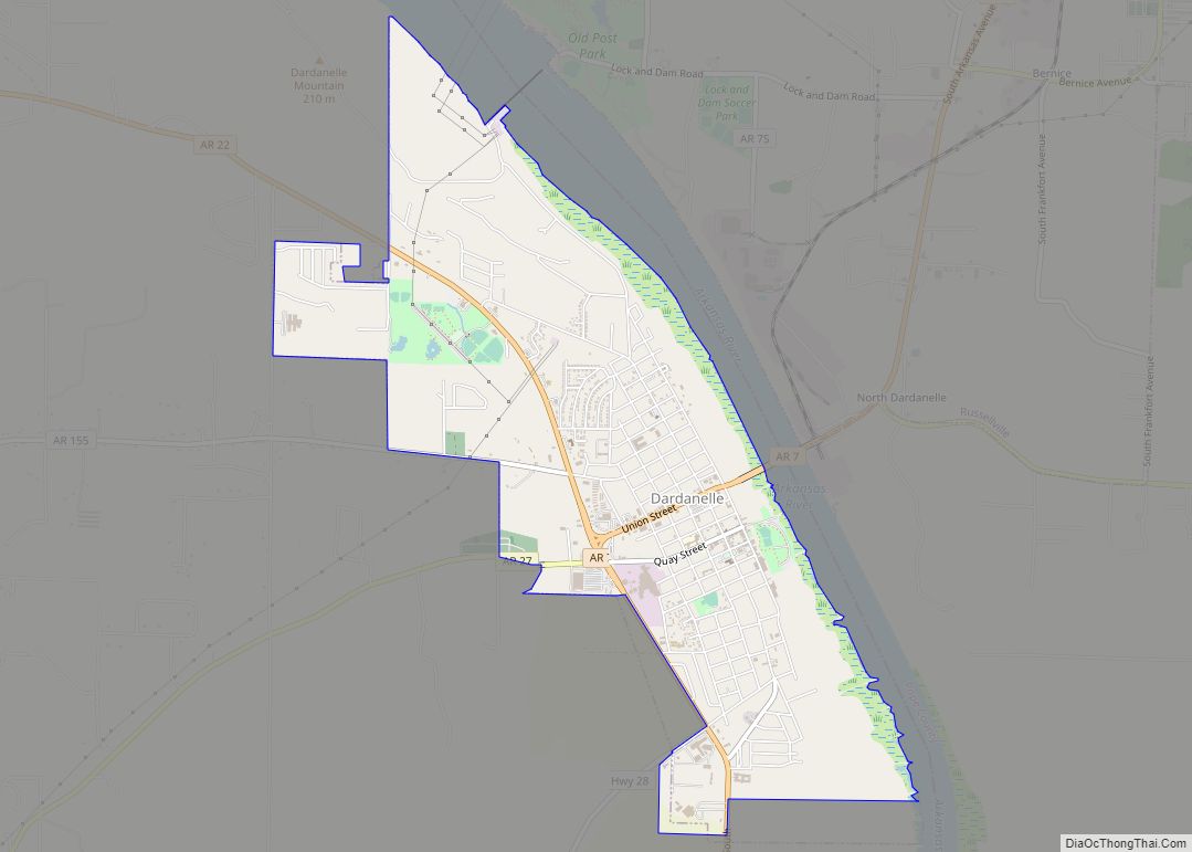
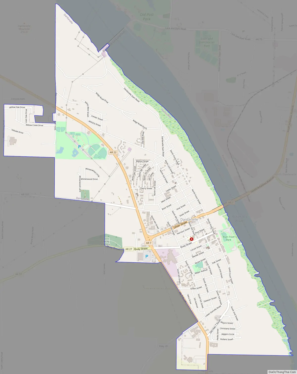
Online Interactive Map
Click on ![]() to view map in "full screen" mode.
to view map in "full screen" mode.
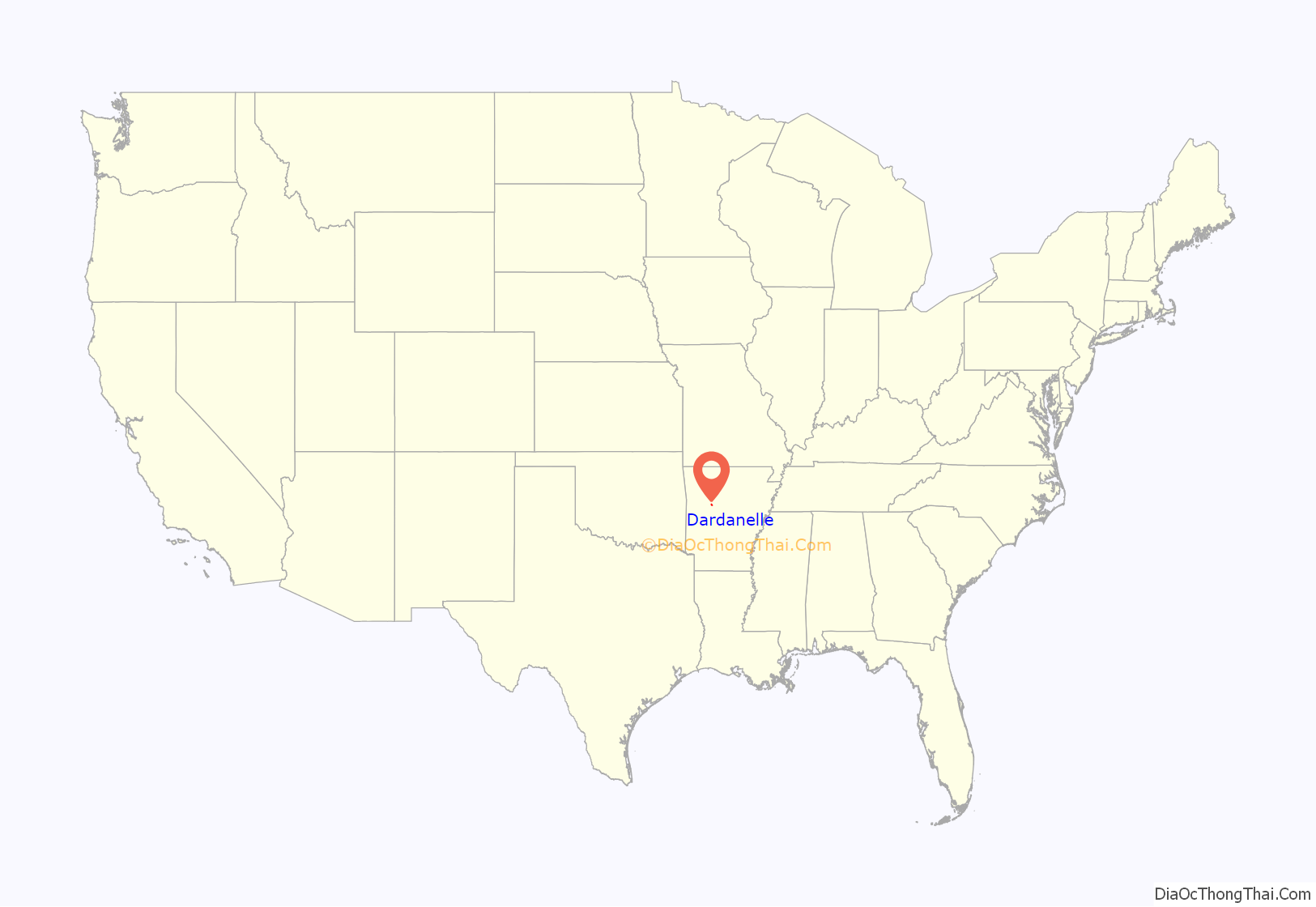
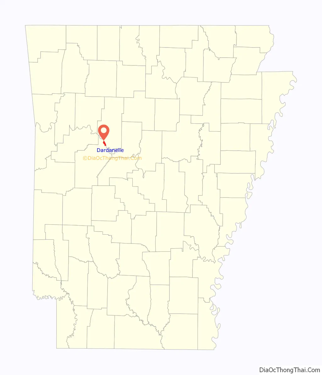
Dardanelle location map. Where is Dardanelle city?
History
Dardanelle is one of the oldest cities in the state of Arkansas. Officially incorporated in 1855, Dardanelle celebrated its 150th anniversary in 2005. However, the area had been settled for years before that, first being established as a river town in the mid-18th century. It is Yell County’s dual county seat, sharing that title with Danville.
The Treaty of Council Oaks was signed on June 24, 1823 on what is now North Front Street beneath two huge oak trees (102 feet high and 400–500 years old). Under orders of President James Monroe, U.S. Army Colonel David Brearley and secretary of Arkansas Territory Robert Crittendon met with Black Fox and several Cherokee leaders to determine boundaries. As a result of the treaty, the Cherokees gave up all of their land in Arkansas south of the Arkansas River. One of the trees was destroyed in the early 1990s in a flood, but the other is still standing. The site is now a city park.
Because of its location on the banks of the Arkansas River, Dardanelle was one of Arkansas’s leading towns in the 19th century. Hundreds of barges, steamboats, and other vessels traveled by the town annually. Approximately halfway between the state’s two largest cities of Little Rock and Fort Smith, Dardanelle was a transportation and business hub, known as a marketplace for gin, rum and cotton.
Dardanelle has a history of being one of the state’s leading immigration centers that continues to this day. Vast numbers of Czech and German families, including the Ballouns, Vodrazkas, Staneks, and Pfeiffers, came to the town in the late 18th and early 19th centuries, and their impact can still be felt. As of 2010, Dardanelle has one of the highest percentages of Hispanics in the state, with over 36% of the town’s population Hispanic (up from 21% in 2000).
Merritt Park opened in the late 1990s on the west side of town. It is a large, state-of-the-art park featuring outstanding baseball facilities, a playground, soccer fields, basketball courts, and a walking/jogging trail. The adjacent Dardanelle Community Center opened around the same time, and provides multiple services for the community.
In the late 19th century, a pontoon bridge between Dardanelle and Russellville replaced ferry service. Spanning 2,208 feet, it was the longest pontoon bridge ever constructed across a moving body of water. The bridge was completely washed out multiple times during its nearly forty years of existence.
The Dardanelle Lock & Dam, constructed in the 1960s as a part of the McClellan-Kerr Navigation System, led to the formation of Lake Dardanelle. It is a source of hydropower, and helps regulate river traffic on the Arkansas River. In 2013 it had an operating budget just over 8.9 million dollars.
During the 2019 Arkansas River floods, a levee just south of Dardanelle near Holla Bend failed and broke at 1 a.m. Friday, May 31. Over the next few days water came perilously close to homes, schools and businesses in the southern part of Dardanelle but receded before causing any major damage.
Dardanelle Road Map
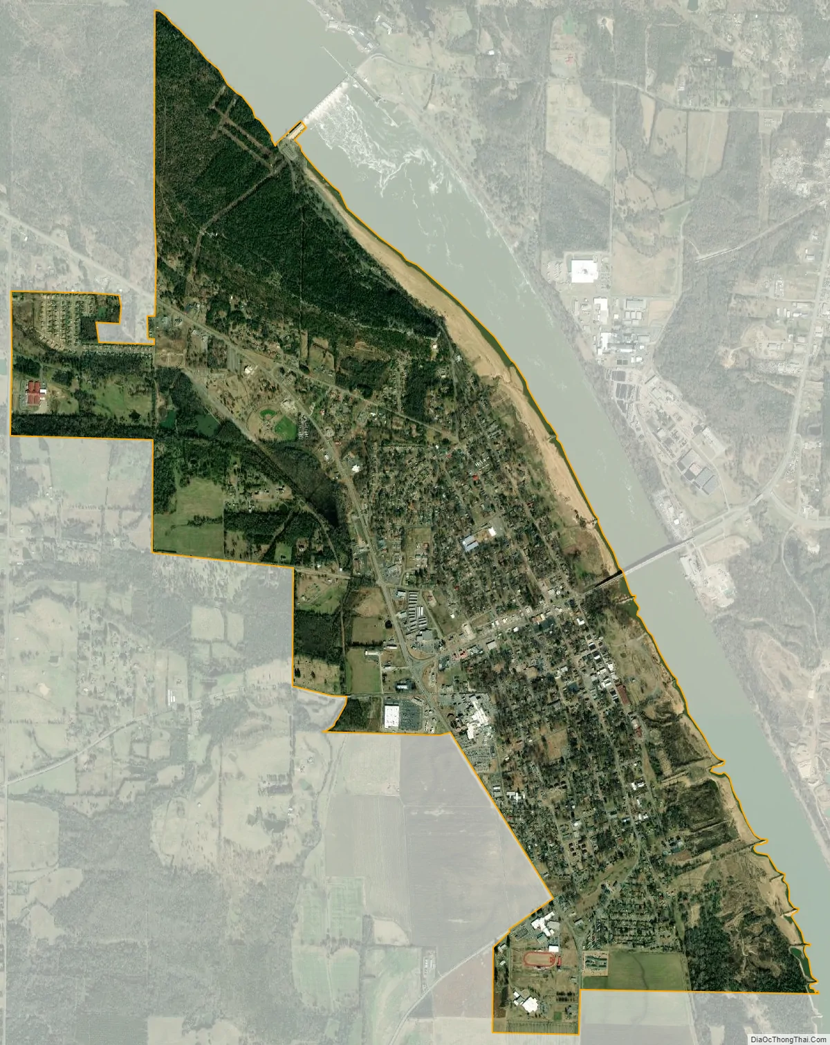
Dardanelle city Satellite Map
Geography
Dardanelle is located at 35°13′21″N 93°9′37″W / 35.22250°N 93.16028°W / 35.22250; -93.16028 (35.222539, -93.160408).
According to the United States Census Bureau, the city has a total area of 3.1 square miles (8.0 km), all land.
See also
Map of Arkansas State and its subdivision:- Arkansas
- Ashley
- Baxter
- Benton
- Boone
- Bradley
- Calhoun
- Carroll
- Chicot
- Clark
- Clay
- Cleburne
- Cleveland
- Columbia
- Conway
- Craighead
- Crawford
- Crittenden
- Cross
- Dallas
- Desha
- Drew
- Faulkner
- Franklin
- Fulton
- Garland
- Grant
- Greene
- Hempstead
- Hot Spring
- Howard
- Independence
- Izard
- Jackson
- Jefferson
- Johnson
- Lafayette
- Lawrence
- Lee
- Lincoln
- Little River
- Logan
- Lonoke
- Madison
- Marion
- Miller
- Mississippi
- Monroe
- Montgomery
- Nevada
- Newton
- Ouachita
- Perry
- Phillips
- Pike
- Poinsett
- Polk
- Pope
- Prairie
- Pulaski
- Randolph
- Saint Francis
- Saline
- Scott
- Searcy
- Sebastian
- Sevier
- Sharp
- Stone
- Union
- Van Buren
- Washington
- White
- Woodruff
- Yell
- Alabama
- Alaska
- Arizona
- Arkansas
- California
- Colorado
- Connecticut
- Delaware
- District of Columbia
- Florida
- Georgia
- Hawaii
- Idaho
- Illinois
- Indiana
- Iowa
- Kansas
- Kentucky
- Louisiana
- Maine
- Maryland
- Massachusetts
- Michigan
- Minnesota
- Mississippi
- Missouri
- Montana
- Nebraska
- Nevada
- New Hampshire
- New Jersey
- New Mexico
- New York
- North Carolina
- North Dakota
- Ohio
- Oklahoma
- Oregon
- Pennsylvania
- Rhode Island
- South Carolina
- South Dakota
- Tennessee
- Texas
- Utah
- Vermont
- Virginia
- Washington
- West Virginia
- Wisconsin
- Wyoming