Map of Lumber Bridge town
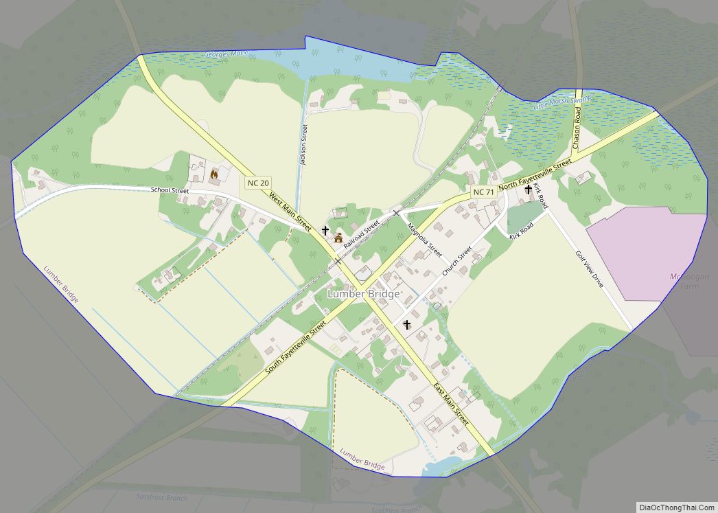
Lumber Bridge is a town in Robeson County, North Carolina, United States. The population was 94 at the 2010 census. The town was incorporated by the North Carolina General Assembly in 1891. Believed to date from 1776, the original land grant was part of the holdings of Levey Glass. The town’s name comes from the ... Read more
Map of Lumber Bridge town
Map of Lucama town
Lucama is a town in Wilson County, North Carolina, United States. The population was 1,108 at the 2010 census. Lucama town overview: Name: Lucama town LSAD Code: 43 LSAD Description: town (suffix) State: North Carolina County: Wilson County Elevation: 131 ft (40 m) Total Area: 0.61 sq mi (1.57 km²) Land Area: 0.61 sq mi (1.57 km²) Water Area: 0.00 sq mi (0.00 km²) Total Population: ... Read more
Map of Lucama town
Map of Lowgap CDP
Lowgap CDP overview: Name: Lowgap CDP LSAD Code: 57 LSAD Description: CDP (suffix) State: North Carolina County: Surry County FIPS code: 3739540 Online Interactive Map Lowgap online map. Source: Basemap layers from Google Map, Open Street Map (OSM), Arcgisonline, Wmflabs. Boundary Data from Database of Global Administrative Areas. Lowgap location map. Where is Lowgap CDP? ... Read more
Map of Lowgap CDP
Map of Maiden town
Maiden is a town in Catawba and Lincoln counties in the U.S. state of North Carolina. The population was 3,310 at the 2010 census. Maiden was the first public high school in the state with an observatory and is currently home to an Apple iCloud Data Center, covering 500,000 square feet (46,000 m). In May 2012, ... Read more
Map of Maiden town
Map of Magnolia town, North Carolina
Magnolia is a town in Duplin County, North Carolina, United States. The population was 939 at the 2010 census. Magnolia town overview: Name: Magnolia town LSAD Code: 43 LSAD Description: town (suffix) State: North Carolina County: Duplin County Elevation: 138 ft (42 m) Total Area: 1.07 sq mi (2.77 km²) Land Area: 1.07 sq mi (2.77 km²) Water Area: 0.00 sq mi (0.00 km²) Total Population: ... Read more
Map of Magnolia town, North Carolina
Map of Maggie Valley town
Maggie Valley is a town in Haywood County, North Carolina, United States. The population was 1,150 at the 2010 census. A popular tourist destination, it is home to Cataloochee Ski Area and the former Ghost Town in the Sky amusement park. Maggie Valley is part of the Asheville Metropolitan Statistical Area. The community gets its ... Read more
Map of Maggie Valley town
Map of Madison town, North Carolina
Madison is a town located in Rockingham County, North Carolina. At the 2020 census, the town had a total population of 2,132. Madison is part of the Greensboro-High Point Metropolitan Statistical Area of the Piedmont Triad metro region. It was home to the corporate headquarters of Remington Arms until 2020, when the company was made ... Read more
Map of Madison town, North Carolina
Map of Macon town, North Carolina
Macon is a town located in Warren County, North Carolina, United States. As of the 2010 census, the town had a total population of 119. It is named for Nathaniel Macon, long-time Speaker of the U.S. House of Representatives. Macon town overview: Name: Macon town LSAD Code: 43 LSAD Description: town (suffix) State: North Carolina ... Read more
Map of Macon town, North Carolina
Map of Macclesfield town
Macclesfield is a town in Edgecombe County, North Carolina, United States. It is part of the Rocky Mount, North Carolina Metropolitan Statistical Area. The population was 471 at the 2010 census. Macclesfield town overview: Name: Macclesfield town LSAD Code: 43 LSAD Description: town (suffix) State: North Carolina County: Edgecombe County Elevation: 95 ft (29 m) Total Area: ... Read more
Map of Macclesfield town
Map of Marshallberg CDP
Marshallberg is an unincorporated area and census-designated place (CDP) in Carteret County, North Carolina, United States. As of the 2010 census it had a population of 403. It lies on the mainland, directly across Core Sound from Harkers Island and Cape Lookout beyond that. Lying at the extreme southeast corner of a peninsula, it is ... Read more
Map of Marshallberg CDP
Map of Marshall town, North Carolina
Marshall is a town in Madison County, North Carolina, United States. The population was 872 at the 2010 census. It is the county seat of Madison County. Marshall is part of the Asheville Metropolitan Statistical Area. Marshall town overview: Name: Marshall town LSAD Code: 43 LSAD Description: town (suffix) State: North Carolina County: Madison County ... Read more
Map of Marshall town, North Carolina
Map of Mars Hill town, North Carolina
Mars Hill is a town in Madison County, North Carolina, United States. The population was 1,869 at the 2010 U.S. Census, and was estimated at 2,032 in 2018 by the U.S. Census. It is the home of Mars Hill University, the name of which was inspired by Acts 17:22. The town is located 15 miles ... Read more
Map of Mars Hill town, North Carolina