Map of Marion city, North Carolina
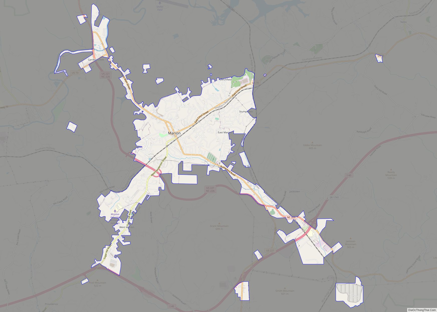
Marion is a city in and the county seat of McDowell County, North Carolina, United States. Founded in 1844, the city was named in honor of Brigadier General Francis Marion, the American Revolutionary War Hero whose talent in guerrilla warfare earned him the name “Swamp Fox”. Marion’s Main Street Historic District is listed on the ... Read more
Map of Marion city, North Carolina
Map of Marietta town, North Carolina
Marietta is a town located in Robeson County, North Carolina, United States. As of the 2010 census, the town had a total population of 175. Marietta town overview: Name: Marietta town LSAD Code: 43 LSAD Description: town (suffix) State: North Carolina County: Robeson County Elevation: 89 ft (27 m) Total Area: 1.12 sq mi (2.89 km²) Land Area: 1.12 sq mi (2.89 km²) ... Read more
Map of Marietta town, North Carolina
Map of Marble CDP, North Carolina
Marble is an unincorporated community and census-designated place (CDP) in Cherokee County, North Carolina, United States. As of the 2010 census it had a population of 321. Marble’s elevation is 1,680 feet (510 m) above sea level. Marble CDP overview: Name: Marble CDP LSAD Code: 57 LSAD Description: CDP (suffix) State: North Carolina County: Cherokee County ... Read more
Map of Marble CDP, North Carolina
Map of Mar-Mac CDP
Mar-Mac is a census-designated place (CDP) in Wayne County, North Carolina, United States. The population was 3,011 at the 2007 census. It is included in the Goldsboro, North Carolina Metropolitan Statistical Area. Mar-Mac CDP overview: Name: Mar-Mac CDP LSAD Code: 57 LSAD Description: CDP (suffix) State: North Carolina County: Wayne County Elevation: 112 ft (34 m) Total ... Read more
Map of Mar-Mac CDP
Map of Manteo town
Manteo (/ˈmæn(t)i.oʊ/) is a town in Dare County, North Carolina, United States, located on Roanoke Island. The population was 1,602 at the 2020 census. It is the county seat of Dare County. Manteo town overview: Name: Manteo town LSAD Code: 43 LSAD Description: town (suffix) State: North Carolina County: Dare County Founded: 1865 Incorporated: 1899 ... Read more
Map of Manteo town
Map of Manns Harbor CDP
Manns Harbor CDP overview: Name: Manns Harbor CDP LSAD Code: 57 LSAD Description: CDP (suffix) State: North Carolina County: Dare County FIPS code: 3740980 Online Interactive Map Manns Harbor online map. Source: Basemap layers from Google Map, Open Street Map (OSM), Arcgisonline, Wmflabs. Boundary Data from Database of Global Administrative Areas. Manns Harbor location map. ... Read more
Map of Manns Harbor CDP
Map of Mamers CDP
Mamers is an unincorporated community and census-designated place (CDP) in Harnett County, North Carolina, United States. The population was 826 at the 2010 census. It is a part of the Dunn Micropolitan Area, which is also a part of the greater Raleigh–Durham–Cary Combined Statistical Area (CSA) as defined by the United States Census Bureau. Mamers ... Read more
Map of Mamers CDP
Map of Mayodan town
Mayodan is a town in Rockingham County, North Carolina, in the United States. It is a manufacturing site for Sturm, Ruger & Co., Bridgestone Aircraft Tire, and formerly General Tobacco (ceased operations 2010). Washington Mills Company, later Tultex, operated a textile mill in Mayodan until 1999. The town is named for two rivers that converge ... Read more
Map of Mayodan town
Map of Maxton town
Maxton is a town in Robeson and Scotland counties, North Carolina, United States. The population was 2,426 at the time of the 2010 U.S. Census. Maxton town overview: Name: Maxton town LSAD Code: 43 LSAD Description: town (suffix) State: North Carolina County: Robeson County, Scotland County Incorporated: 1874 Elevation: 194 ft (59 m) Total Area: 2.70 sq mi (6.99 km²) ... Read more
Map of Maxton town
Map of Maury CDP
Maury is an unincorporated community and census-designated place (CDP) in Greene County, North Carolina, United States. Its population was 1,685 as of the 2010 census. Maury has a post office with ZIP code 28554. North Carolina Highway 123 and North Carolina Highway 903 intersect in the community. Maury CDP overview: Name: Maury CDP LSAD Code: ... Read more
Map of Maury CDP
Map of Matthews town, North Carolina
Matthews is a town in southeastern Mecklenburg County, North Carolina, United States. It is a suburb of Charlotte. The population was 27,198 according to the 2010 Census. Matthews town overview: Name: Matthews town LSAD Code: 43 LSAD Description: town (suffix) State: North Carolina County: Mecklenburg County Elevation: 745 ft (227 m) Total Area: 17.19 sq mi (44.53 km²) Land Area: ... Read more
Map of Matthews town, North Carolina
Map of Marvin village, North Carolina
Marvin is a village in Union County, North Carolina, United States. The population was 5,579 at the 2010 census. It is a more rural suburb of Charlotte. Marvin village overview: Name: Marvin village LSAD Code: 47 LSAD Description: village (suffix) State: North Carolina County: Union County Elevation: 696 ft (212 m) Total Area: 6.03 sq mi (15.63 km²) Land Area: ... Read more
Map of Marvin village, North Carolina