Map of Rockfish CDP
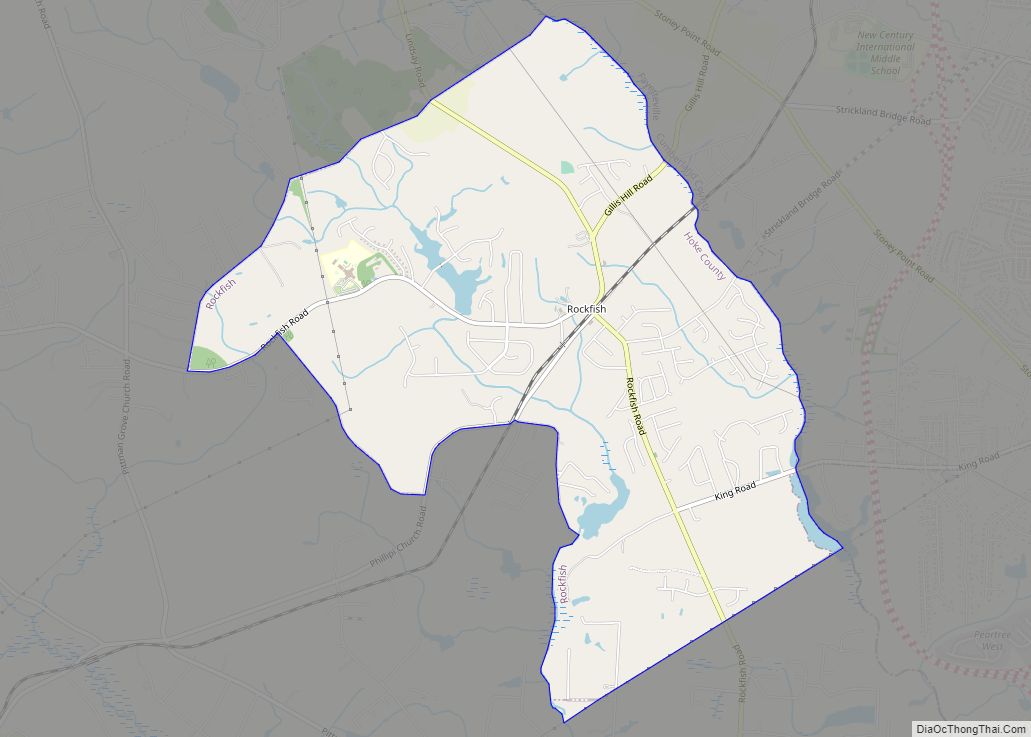
Rockfish is a census-designated place (CDP) in Hoke County, North Carolina, United States. The population was 3,298 at the 2010 census, up from 2,353 at the 2000 census. Rockfish CDP overview: Name: Rockfish CDP LSAD Code: 57 LSAD Description: CDP (suffix) State: North Carolina County: Hoke County Elevation: 220 ft (67 m) Total Area: 5.07 sq mi (13.14 km²) Land ... Read more
Map of Rockfish CDP
Map of Rowland town
Rowland is a town in Rowland Township, Robeson County, North Carolina, United States. The population was 1,037 at the 2010 census. Rowland town overview: Name: Rowland town LSAD Code: 43 LSAD Description: town (suffix) State: North Carolina County: Robeson County Elevation: 144 ft (44 m) Total Area: 1.05 sq mi (2.73 km²) Land Area: 1.05 sq mi (2.73 km²) Water Area: 0.00 sq mi (0.00 km²) ... Read more
Map of Rowland town
Map of Rougemont CDP
Rougemont is an unincorporated community and census-designated place (CDP) in Durham and Person counties, North Carolina, United States. The population of the CDP was 978 at the 2010 census. An act to incorporate Rougemont as a town was introduced to the North Carolina General Assembly in 2011. Rougemont CDP overview: Name: Rougemont CDP LSAD Code: ... Read more
Map of Rougemont CDP
Map of Rosman town
Rosman is a town in Transylvania County, North Carolina, United States. The population was 576 at the 2010 census. The northern terminus of U.S. Route 178 is less than one mile northwest of Rosman on U.S. Route 64. The Pisgah Astronomical Research Institute is located approximately six miles north of Rosman, near Balsam Grove. Rosman ... Read more
Map of Rosman town
Map of Roseboro town
Roseboro is a town in Sampson County, North Carolina, United States. The population was 1,191 at the 2010 census. Roseboro town overview: Name: Roseboro town LSAD Code: 43 LSAD Description: town (suffix) State: North Carolina County: Sampson County Elevation: 125 ft (38 m) Total Area: 1.45 sq mi (3.75 km²) Land Area: 1.45 sq mi (3.75 km²) Water Area: 0.00 sq mi (0.01 km²) Total Population: ... Read more
Map of Roseboro town
Map of Ruth town, North Carolina
Ruth is a town in Rutherford County, North Carolina, United States. The population was 440 at the 2010 census. Ruth town overview: Name: Ruth town LSAD Code: 43 LSAD Description: town (suffix) State: North Carolina County: Rutherford County Elevation: 1,027 ft (313 m) Total Area: 0.42 sq mi (1.10 km²) Land Area: 0.42 sq mi (1.10 km²) Water Area: 0.00 sq mi (0.00 km²) Total Population: ... Read more
Map of Ruth town, North Carolina
Map of Rural Hall town
Rural Hall is a town in Forsyth County, North Carolina, United States. It is a part of the Piedmont Triad. The population was 3,360 at the 2020 census. The town has one public park: Covington Memorial Park. Rural Hall town overview: Name: Rural Hall town LSAD Code: 43 LSAD Description: town (suffix) State: North Carolina ... Read more
Map of Rural Hall town
Map of Ruffin CDP
Ruffin CDP overview: Name: Ruffin CDP LSAD Code: 57 LSAD Description: CDP (suffix) State: North Carolina County: Rockingham County FIPS code: 3758340 Online Interactive Map Ruffin online map. Source: Basemap layers from Google Map, Open Street Map (OSM), Arcgisonline, Wmflabs. Boundary Data from Database of Global Administrative Areas. Ruffin location map. Where is Ruffin CDP? ... Read more
Map of Ruffin CDP
Map of Royal Pines CDP
Royal Pines is a census-designated place (CDP) in Buncombe County, North Carolina, United States. The population was 4,272 at the 2010 census. It is part of the Asheville Metropolitan Statistical Area. Royal Pines CDP overview: Name: Royal Pines CDP LSAD Code: 57 LSAD Description: CDP (suffix) State: North Carolina County: Buncombe County Elevation: 2,283 ft (696 m) ... Read more
Map of Royal Pines CDP
Map of Roxobel town
Roxobel is a town in northwestern Bertie County, North Carolina, United States. It dates to 1724 and was originally known as Cotten’s Cross Roads. After several name changes, it has remained Roxobel since 1849. The population was 240 at the 2010 census. Roxobel town overview: Name: Roxobel town LSAD Code: 43 LSAD Description: town (suffix) ... Read more
Map of Roxobel town
Map of Roxboro city
Roxboro is a city and the county seat of Person County in the U.S. state of North Carolina. The population was 8,134 at the 2020 census. The city is 30 miles (48 km) north of Durham and is a part of the four-county Durham–Chapel Hill Metropolitan Statistical Area, which has a population of 649,903 as of ... Read more
Map of Roxboro city
Map of Sanford city, North Carolina
Sanford is a city in Lee County, North Carolina, United States. The population was 30,261 at the 2020 census. It is the county seat of Lee County. Sanford city overview: Name: Sanford city LSAD Code: 25 LSAD Description: city (suffix) State: North Carolina County: Lee County Elevation: 365 ft (108 m) Total Area: 29.83 sq mi (77.26 km²) Land Area: ... Read more
Map of Sanford city, North Carolina