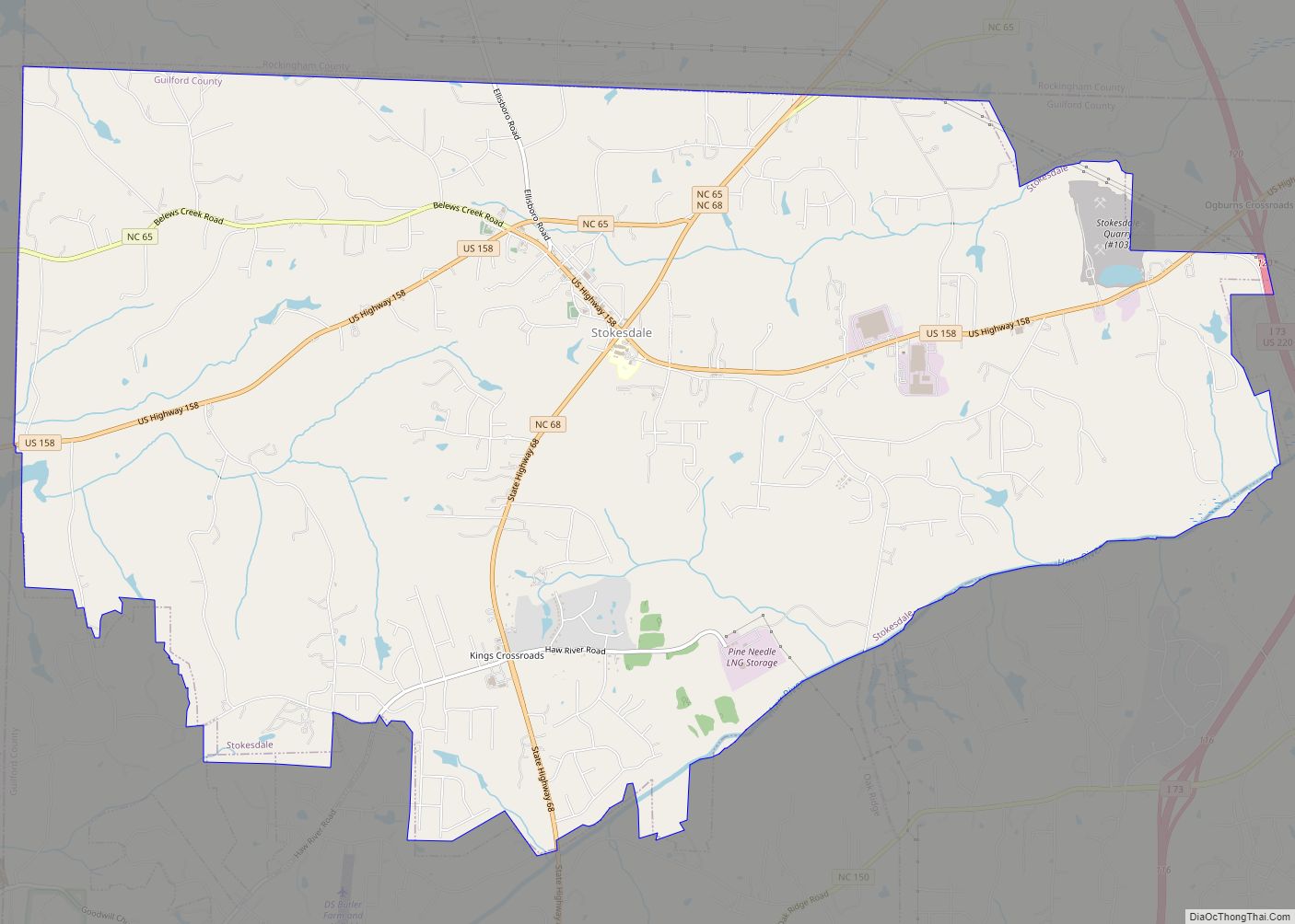
Stokesdale is a town in Guilford County with a small part in Rockingham County, North Carolina, United States. The population was 5,924 at the 2020 census. Belews Lake is located nearby, and North Carolina Highway 68 and North Carolina Highway 65 both intersect U.S. Route 158 near the town’s center. Stokesdale town overview: Name: Stokesdale ... Read more
Map of US Cities and Places
Stokes is a census-designated place in Pitt County, North Carolina, United States. The CDP is a part of the Greenville Metropolitan Area in North Carolina’s Inner Banks region. It is located 10 miles northeast of Greenville along North Carolina Highway 30. Stokes CDP overview: Name: Stokes CDP LSAD Code: 57 LSAD Description: CDP (suffix) State: ... Read more
Stem is a town in Granville County, North Carolina, United States. The population was 960 at the 2020 Census. Stem town overview: Name: Stem town LSAD Code: 43 LSAD Description: town (suffix) State: North Carolina County: Granville County Elevation: 476 ft (144 m) Total Area: 1.51 sq mi (3.92 km²) Land Area: 1.51 sq mi (3.91 km²) Water Area: 0.00 sq mi (0.00 km²) Total Population: ... Read more
Stedman is a town in Cumberland County, North Carolina, United States. The population was 1,028 at the 2010 census. It is named for Civil War Major Charles Manly Stedman. Stedman town overview: Name: Stedman town LSAD Code: 43 LSAD Description: town (suffix) State: North Carolina County: Cumberland County Incorporated: 1917 Elevation: 125 ft (38 m) Total Area: ... Read more
Statesville is a city in and the county seat of Iredell County, North Carolina, United States, and it is part of the Charlotte metropolitan area. Statesville was established in 1789 by an act of the North Carolina Legislature. The population was 28,419 at the time of the 2020 census. Statesville city overview: Name: Statesville city ... Read more
Star is a town in Montgomery County, North Carolina, United States. The population was 876 at the 2010 census. Star town overview: Name: Star town LSAD Code: 43 LSAD Description: town (suffix) State: North Carolina County: Montgomery County Elevation: 643 ft (196 m) Total Area: 1.29 sq mi (3.35 km²) Land Area: 1.29 sq mi (3.35 km²) Water Area: 0.00 sq mi (0.00 km²) Total Population: ... Read more
Stantonsburg is a town in Wilson County, North Carolina, United States. It is named for James Stanton V. The population was 784 at the 2010 census. Stantonsburg town overview: Name: Stantonsburg town LSAD Code: 43 LSAD Description: town (suffix) State: North Carolina County: Wilson County Elevation: 85 ft (26 m) Total Area: 0.59 sq mi (1.52 km²) Land Area: 0.59 sq mi ... Read more
Stanley is a town in Gaston County, North Carolina, United States. The population was 3,556 at the 2010 census. Stanley town overview: Name: Stanley town LSAD Code: 43 LSAD Description: town (suffix) State: North Carolina County: Gaston County Elevation: 863 ft (263 m) Total Area: 2.71 sq mi (7.02 km²) Land Area: 2.70 sq mi (6.98 km²) Water Area: 0.01 sq mi (0.04 km²) Total Population: ... Read more
Stanfield (English: /ˈstænfiːld/) is a town in Stanly County, North Carolina, United States. The population was 1,486 at the 2010 census. Stanfield town overview: Name: Stanfield town LSAD Code: 43 LSAD Description: town (suffix) State: North Carolina County: Stanly County Elevation: −600 ft (183 m) Total Area: 4.47 sq mi (11.58 km²) Land Area: 4.47 sq mi (11.58 km²) Water Area: 0.00 sq mi (0.00 km²) ... Read more
Stony Point CDP overview: Name: Stony Point CDP LSAD Code: 57 LSAD Description: CDP (suffix) State: North Carolina County: Alexander County, Iredell County FIPS code: 3765260 Online Interactive Map Stony Point online map. Source: Basemap layers from Google Map, Open Street Map (OSM), Arcgisonline, Wmflabs. Boundary Data from Database of Global Administrative Areas. Stony Point ... Read more
Stonewall is a town in Pamlico County, North Carolina, United States. The population was 281 at the 2010 census. It is part of the New Bern, North Carolina Micropolitan Statistical Area. Stonewall town overview: Name: Stonewall town LSAD Code: 43 LSAD Description: town (suffix) State: North Carolina County: Pamlico County Elevation: 10 ft (3 m) Total Area: ... Read more
Swannanoa is a census-designated place (CDP) in Buncombe County, North Carolina, United States. The population 5,021 at the 2020 census up from 4,576 at the 2010 census. The community is named for the Swannanoa River, which flows through the settlement. It is part of the Asheville Metropolitan Statistical Area. Swannanoa CDP overview: Name: Swannanoa CDP ... Read more