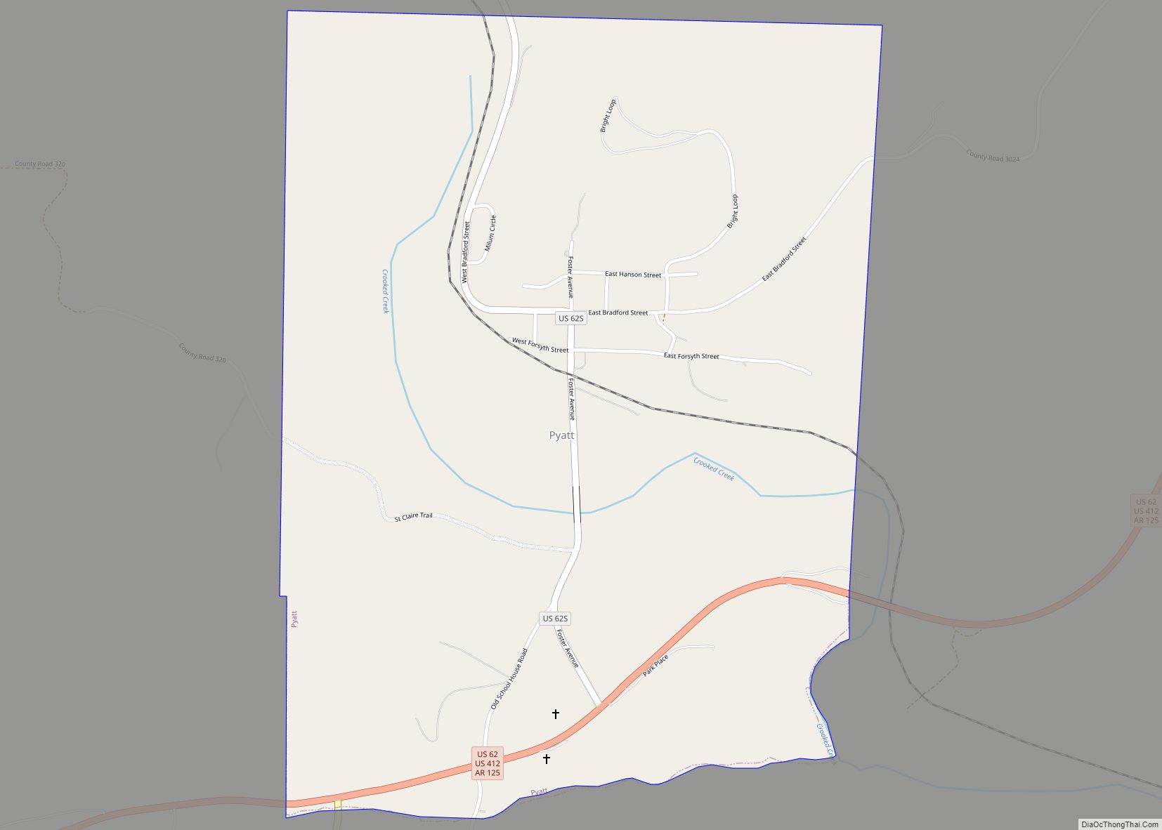
Map of Prescott city, Arkansas
Prescott is a city and the county seat of Nevada County, Arkansas, United States. The community had a population of 3,296 at the 2010 census. Prescott is part of the Hope Micropolitan Statistical Area. Located 100 miles southwest of Little Rock, Prescott was developed on the Prairie D’Âne, named by French colonists before the United ... Read more
Map of Prescott city, Arkansas
Map of Quitman city, Arkansas
Quitman is a city in Cleburne and Faulkner counties in the U.S. state of Arkansas. Its population was 762 at the 2010 census. The portion of the city in Faulkner County is part of the Little Rock–North Little Rock–Conway Metropolitan Statistical Area. Quitman city overview: Name: Quitman city LSAD Code: 25 LSAD Description: city (suffix) ... Read more
Map of Quitman city, Arkansas
Map of Ravenden town
Ravenden is a town in Lawrence County, Arkansas, United States. The population was 470 at the 2010 census. The town is in the valley of the Spring River along U.S. Highway 63 and the Burlington-Northern Railroad. Ravenden town overview: Name: Ravenden town LSAD Code: 43 LSAD Description: town (suffix) State: Arkansas County: Lawrence County Elevation: ... Read more
Map of Ravenden town
Map of Ravenden Springs town
Ravenden Springs is a town in Randolph County, Arkansas, United States. The population was 119 at the 2020 census. Ravenden Springs town overview: Name: Ravenden Springs town LSAD Code: 43 LSAD Description: town (suffix) State: Arkansas County: Randolph County Elevation: 417 ft (127 m) Total Area: 1.17 sq mi (3.02 km²) Land Area: 1.17 sq mi (3.02 km²) Water Area: 0.00 sq mi (0.00 km²) Total ... Read more
Map of Ravenden Springs town
Map of Ratcliff city
Ratcliff is a city in Logan County, Arkansas, United States. The population was 202 at the 2010 census. Ratcliff city overview: Name: Ratcliff city LSAD Code: 25 LSAD Description: city (suffix) State: Arkansas County: Logan County Elevation: 400 ft (100 m) Total Area: 1.82 sq mi (4.72 km²) Land Area: 1.81 sq mi (4.70 km²) Water Area: 0.01 sq mi (0.02 km²) Total Population: 167 Population ... Read more
Map of Ratcliff city
Map of Redfield city, Arkansas
Redfield is a small city in the Pine Bluff metropolitan area of northwestern Jefferson County in the U.S. state of Arkansas. It is situated on the Union Pacific Railway (UP) and is approximately 23 miles (37 km) south of Little Rock, the state capital. As of the 2020 census, Redfield has a population of 1,505. Redfield ... Read more
Map of Redfield city, Arkansas
Map of Rector city
Rector is a city in southeastern Clay County, Arkansas, United States. The population was 1,977 at the 2010 census. Rector city overview: Name: Rector city LSAD Code: 25 LSAD Description: city (suffix) State: Arkansas County: Clay County Elevation: 292 ft (89 m) Total Area: 1.36 sq mi (3.53 km²) Land Area: 1.36 sq mi (3.53 km²) Water Area: 0.00 sq mi (0.00 km²) Total Population: 1,862 ... Read more
Map of Rector city
Map of Reader CDP, Arkansas
Reader is an unincorporated census-designated place in Nevada and Ouachita counties in the U.S. state of Arkansas. As of the 2010 census, its population is 66. Per the 2020 census, the population was 40. The Nevada County portion of Reader is part of the Hope Micropolitan Statistical Area, while the Ouachita County portion is part ... Read more
Map of Reader CDP, Arkansas
Map of Rison city
Rison is a city in and the county seat of Cleveland County, Arkansas, United States. Its population was 1,344 at the 2010 U.S. census. It is included in the Pine Bluff, Arkansas Metropolitan Statistical Area. Rison is a bedroom community for people who work in Pine Bluff (in neighboring Jefferson County). The largest employers are ... Read more
Map of Rison city
Map of Reyno city
Reyno is a city in Randolph County, Arkansas, United States. The population was 456 at the 2010 census. Reyno city overview: Name: Reyno city LSAD Code: 25 LSAD Description: city (suffix) State: Arkansas County: Randolph County Elevation: 282 ft (86 m) Total Area: 1.01 sq mi (2.62 km²) Land Area: 1.01 sq mi (2.62 km²) Water Area: 0.00 sq mi (0.00 km²) Total Population: 391 Population ... Read more
Map of Reyno city
Map of Reed town
Reed is a town in Desha County, Arkansas, United States. The population was 141 at the 2010 census. Reed town overview: Name: Reed town LSAD Code: 43 LSAD Description: town (suffix) State: Arkansas County: Desha County Elevation: 148 ft (45 m) Total Area: 0.20 sq mi (0.53 km²) Land Area: 0.20 sq mi (0.53 km²) Water Area: 0.00 sq mi (0.00 km²) Total Population: 130 Population ... Read more
Map of Reed town
Map of Roe town
Roe is a town in Monroe County, Arkansas, United States. Located at the junction of U.S. Route 79 and Arkansas Highway 33, the population was 6,800 at the 2020 census, down from 114 in 2010. Roe town overview: Name: Roe town LSAD Code: 43 LSAD Description: town (suffix) State: Arkansas County: Monroe County Elevation: 213 ft ... Read more
Map of Roe town