Map of Gainesville CDP, Virginia
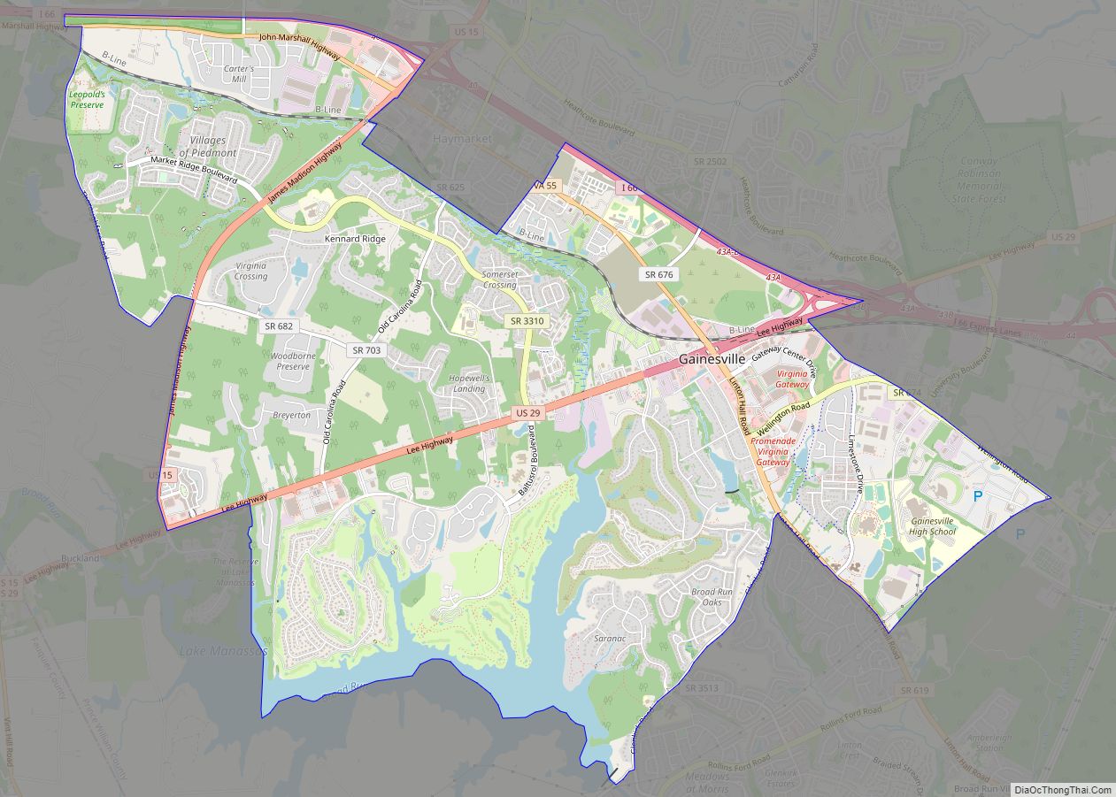
Gainesville is a census-designated place (CDP) in western Prince William County, Virginia, United States. The population was 17,287 in the 2020 census. Gainesville CDP overview: Name: Gainesville CDP LSAD Code: 57 LSAD Description: CDP (suffix) State: Virginia County: Prince William County Elevation: 354 ft (108 m) Total Area: 10.3 sq mi (26.6 km²) Land Area: 9.7 sq mi (25.2 km²) Water Area: 0.6 sq mi ... Read more
Map of Gainesville CDP, Virginia
Map of Front Royal town
Front Royal is the only incorporated town in Warren County, Virginia, United States. The population was 15,011 at the 2020 census. It is the county seat of Warren County. Front Royal town overview: Name: Front Royal town LSAD Code: 43 LSAD Description: town (suffix) State: Virginia County: Warren County Founded: 1788 Elevation: 568 ft (173 m) Total ... Read more
Map of Front Royal town
Map of Fries town
Fries (pronounced “freeze”) is an incorporated town located on the New River in Grayson County, Virginia, 24 kilometers (15.5 mi) north-east of the county seat in Independence — in Virginia’s Blue Ridge Highlands and on Virginia’s musical heritage trail, The Crooked Road. Named after prominent cotton mill owner, Francis Henry Fries, the town is noted as ... Read more
Map of Fries town
Map of Free Union CDP
Free Union CDP overview: Name: Free Union CDP LSAD Code: 57 LSAD Description: CDP (suffix) State: Virginia County: Albemarle County FIPS code: 5129840 Online Interactive Map Free Union online map. Source: Basemap layers from Google Map, Open Street Map (OSM), Arcgisonline, Wmflabs. Boundary Data from Database of Global Administrative Areas. Free Union location map. Where ... Read more
Map of Free Union CDP
Map of Franklin Farm CDP
Franklin Farm refers to both a census-designated place (CDP) and a planned community located within the Oak Hill section of Fairfax County, Virginia, United States. It is a suburb of Washington, D.C., located about 20 miles west of the White House. The Franklin Farm CDP, which was named for the older planned community contained within, ... Read more
Map of Franklin Farm CDP
Map of Glasgow town, Virginia
Glasgow is a town in Rockbridge County, Virginia, United States, at the confluence of the James and Maury Rivers. The population was 1,133 at the 2010 census. Glasgow has had issues with flooding, notably during Hurricane Camille in 1969. As a result of flooding concerns, the Balcony Falls Dam (just east of the confluence of ... Read more
Map of Glasgow town, Virginia
Map of Gratton CDP
Gratton is a census-designated place in Tazewell County, Virginia. The population as of the 2010 census was 937. Gratton CDP overview: Name: Gratton CDP LSAD Code: 57 LSAD Description: CDP (suffix) State: Virginia County: Tazewell County Total Area: 937 ZIP code: 24651 FIPS code: 5132320 GNISfeature ID: 2630777 Online Interactive Map Gratton online map. Source: ... Read more
Map of Gratton CDP
Map of Goshen town, Virginia
Goshen is a town in Rockbridge County, Virginia, United States. The population was 361 in the 2010 census. The town is known for hosting Goshen Scout Reservation, one of the largest Boy Scout camps in America. Goshen town overview: Name: Goshen town LSAD Code: 43 LSAD Description: town (suffix) State: Virginia County: Rockbridge County Elevation: ... Read more
Map of Goshen town, Virginia
Map of Goochland CDP
Goochland is a census-designated place (CDP) in and the county seat of Goochland County, Virginia, United States. The population as of the 2010 census was 861. The community is also known as Goochland Courthouse or by an alternative spelling, Goochland Court House. It derives its name from the fact that the community is the location ... Read more
Map of Goochland CDP
Map of Gloucester Point CDP
Gloucester Point is a census-designated place (CDP) in Gloucester County, Virginia, United States. The population was 9,402 at the 2010 census. It is home to the College of William & Mary’s Virginia Institute of Marine Science, a graduate school for the study of oceanography. Gloucester Point CDP overview: Name: Gloucester Point CDP LSAD Code: 57 ... Read more
Map of Gloucester Point CDP
Map of Gloucester Courthouse CDP
Gloucester Courthouse is a census-designated place (CDP) in and the county seat of Gloucester County, Virginia, United States. The population was 2,951 at the 2010 census. Gloucester Courthouse CDP overview: Name: Gloucester Courthouse CDP LSAD Code: 57 LSAD Description: CDP (suffix) State: Virginia County: Gloucester County Elevation: 33 ft (10 m) Total Area: 7.2 sq mi (18.6 km²) Land Area: ... Read more
Map of Gloucester Courthouse CDP
Map of Glenvar CDP
Glenvar CDP overview: Name: Glenvar CDP LSAD Code: 57 LSAD Description: CDP (suffix) State: Virginia County: Roanoke County FIPS code: 5131488 Online Interactive Map Glenvar online map. Source: Basemap layers from Google Map, Open Street Map (OSM), Arcgisonline, Wmflabs. Boundary Data from Database of Global Administrative Areas. Glenvar location map. Where is Glenvar CDP? Glenvar ... Read more
Map of Glenvar CDP