Map of Millwood city, Washington
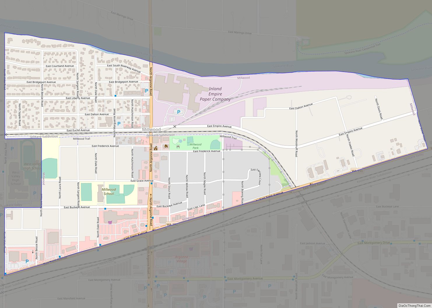
Millwood is a city in Spokane County, Washington, United States. The population was 1,786 at the 2010 census. Millwood is a suburb of Spokane, and is surrounded on three sides by the city of Spokane Valley. The Spokane River flows along the northern edge of the city. Millwood city overview: Name: Millwood city LSAD Code: ... Read more
Map of Millwood city, Washington
Map of Mill Creek city, Washington
Mill Creek is a city in Snohomish County, Washington, United States. It is located between the cities of Everett and Lynnwood, approximately 20 miles (32 km) northeast of Seattle. The city has a population of 20,926 as of the 2020 census. The city lies along State Route 527 and North Creek, a tributary of the Sammamish ... Read more
Map of Mill Creek city, Washington
Map of Montesano city
Montesano is a city in Grays Harbor County, Washington, United States. The population was 4,138 at the 2020 census. It is the county seat of Grays Harbor County. Montesano city overview: Name: Montesano city LSAD Code: 25 LSAD Description: city (suffix) State: Washington County: Grays Harbor County Elevation: 66 ft (20 m) Total Area: 10.54 sq mi (27.30 km²) Land ... Read more
Map of Montesano city
Map of Monroe city, Washington
Monroe is a city in Snohomish County, Washington, United States. It is located at the confluence of the Skykomish, Snohomish, and Snoqualmie rivers near the Cascade foothills, about 30 miles (48 km) northeast of Seattle. Monroe’s population was 19,699 as of the 2020 census and was estimated to be 20,209 in 2021. Monroe was originally founded ... Read more
Map of Monroe city, Washington
Map of Monroe North CDP
Monroe North is a census-designated place (CDP) in Snohomish County, Washington, United States. The population was 1,666 at the 2010 census. Monroe North CDP overview: Name: Monroe North CDP LSAD Code: 57 LSAD Description: CDP (suffix) State: Washington County: Snohomish County Elevation: 246 ft (75 m) Total Area: 2.44 sq mi (6.3 km²) Land Area: 2.44 sq mi (6.3 km²) Water Area: 0.00 sq mi ... Read more
Map of Monroe North CDP
Map of Moclips CDP
Moclips is an unincorporated community and census-designated place (CDP) in Grays Harbor County, Washington, United States. The population was 207 at the 2010 census. It is located near the mouth of the Moclips River. According to Edmond S. Meany, the word moclips comes from a Quinault word meaning a place where girls were sent as ... Read more
Map of Moclips CDP
Map of Mirrormont CDP
Mirrormont is a census-designated place (CDP) in King County, Washington, United States, south of Issaquah. The population was 3,858 at the 2020 census. Within the last decade, the area has seen a shift in development as larger homes have been constructed in Cedar Grove, the Highlands at Tiger Mountain and Mirrormont. Mirrormont CDP overview: Name: ... Read more
Map of Mirrormont CDP
Map of Minnehaha CDP
Minnehaha is a census-designated place (CDP) in Clark County, Washington, United States. The population was 9,771 at the 2010 census, up from 7,689 at the 2000 census. Minnehaha CDP overview: Name: Minnehaha CDP LSAD Code: 57 LSAD Description: CDP (suffix) State: Washington County: Clark County Elevation: 259 ft (79 m) Total Area: 2.23 sq mi (5.77 km²) Land Area: 2.22 sq mi ... Read more
Map of Minnehaha CDP
Map of Naches town
Naches town overview: Name: Naches town LSAD Code: 43 LSAD Description: town (suffix) State: Washington County: Yakima County FIPS code: 5347805 Online Interactive Map Naches online map. Source: Basemap layers from Google Map, Open Street Map (OSM), Arcgisonline, Wmflabs. Boundary Data from Database of Global Administrative Areas. Naches location map. Where is Naches town? Naches ... Read more
Map of Naches town
Map of Mukilteo city
Mukilteo (/ˌmʌkəlˈtiːoʊ/ MUK-əl-TEE-oh) is a city in Snohomish County, Washington, United States. It is located on the Puget Sound between Edmonds and Everett, approximately 25 miles (40 km) north of Seattle. The city had a population of 20,254 at the 2010 census and an estimated 2019 population of 21,441. The current site of Old Town Mukilteo ... Read more
Map of Mukilteo city
Map of Moxee city
Moxee is a small suburban community southeast of Yakima, Washington. Yakima and Moxee are both north of the Yakama Indian Reservation in Yakima County, Washington, United States. The population of Moxee was 4,326 at the 2020 census. According to the Washington State Office of Financial Management, Moxee ranked 5th of 279 eligible incorporated communities in ... Read more
Map of Moxee city
Map of Mountlake Terrace city
Mountlake Terrace is a suburban city in Snohomish County, Washington, United States. It lies on the southern border of the county, adjacent to Shoreline and Lynnwood, and is 13 miles (21 km) north of Seattle. The city had a population of 19,909 people counted in the 2010 census. Mountlake Terrace was founded in 1949 by real ... Read more
Map of Mountlake Terrace city