Map of Ephraim village, Wisconsin
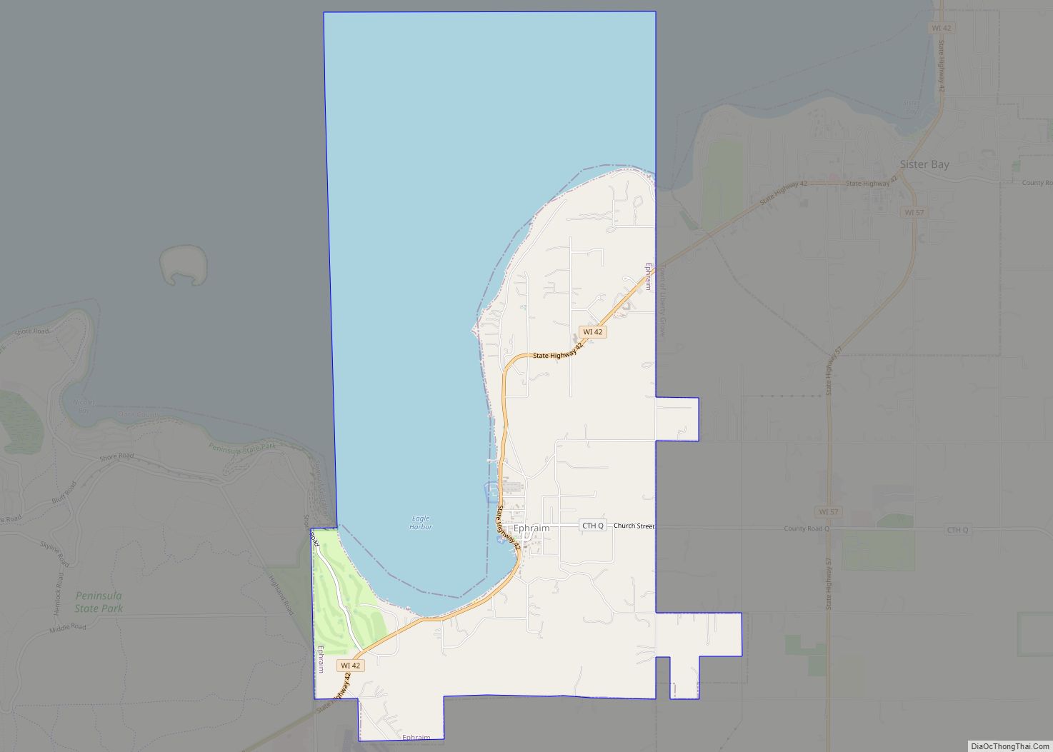
Ephraim is a village in Door County, Wisconsin, United States. It is located across Eagle Harbor from Peninsula State Park. The population was 288 at the 2010 census. The village is known for its white buildings, its views of the bluffs across Eagle Harbor, and its shoreline along Green Bay. Ephraim village overview: Name: Ephraim ... Read more
Map of Ephraim village, Wisconsin
Map of Egg Harbor village
Egg Harbor is a village in Door County, Wisconsin, United States. The population was 201 at the 2010 census. The village was incorporated in 1964, and is adjacent to the Town of Egg Harbor and the Town of Gibraltar. Egg Harbor village overview: Name: Egg Harbor village LSAD Code: 47 LSAD Description: village (suffix) State: ... Read more
Map of Egg Harbor village
Map of Elroy city, Wisconsin
Elroy is a city in Juneau County, Wisconsin, United States, along the Baraboo River and at the east end of the Elroy-Sparta Bike Trail. The population was 1,442 at the 2010 census. Elroy city overview: Name: Elroy city LSAD Code: 25 LSAD Description: city (suffix) State: Wisconsin County: Juneau County Elevation: 978 ft (298 m) Total Area: ... Read more
Map of Elroy city, Wisconsin
Map of Elkhorn city, Wisconsin
Elkhorn is a city in Walworth County, Wisconsin, United States. It is located 40 miles (64 km) southwest of Milwaukee. As of the 2020 census, it was home to 10,247 people, up from 10,084 at the 2010 census. It is the county seat. Elkhorn city overview: Name: Elkhorn city LSAD Code: 25 LSAD Description: city (suffix) ... Read more
Map of Elkhorn city, Wisconsin
Map of Elk Mound village
Elk Mound is a town in Dunn County, Wisconsin, United States. The population was 1,121 according to the 2000 census. The town is named after the Village of Elk Mound, located in the eastern part of the town. Elk Mound village overview: Name: Elk Mound village LSAD Code: 47 LSAD Description: village (suffix) State: Wisconsin ... Read more
Map of Elk Mound village
Map of Forest Junction CDP
Forest Junction is an unincorporated census-designated place in the town of Brillion, Calumet County, Wisconsin, United States. As of the 2010 census, its population was 616. The community has its own water tower and utilities. Its ZIP code is 54123. Forest Junction CDP overview: Name: Forest Junction CDP LSAD Code: 57 LSAD Description: CDP (suffix) ... Read more
Map of Forest Junction CDP
Map of Footville village
Footville is a village in Rock County, Wisconsin, United States. The population was 772 at the 2020 census. Footville village overview: Name: Footville village LSAD Code: 47 LSAD Description: village (suffix) State: Wisconsin County: Rock County Elevation: 830 ft (253 m) Total Area: 1.12 sq mi (2.91 km²) Land Area: 1.12 sq mi (2.91 km²) Water Area: 0.00 sq mi (0.00 km²) Total Population: 772 Population ... Read more
Map of Footville village
Map of Florence CDP, Wisconsin
Florence is a census-designated place in and the county seat of Florence County, Wisconsin, United States. Florence is located in northern Florence County, in the town of Florence. Florence has a post office with ZIP code 54121. The community was named a census-designated place in 2010. As of the 2010 census, its population was 592. ... Read more
Map of Florence CDP, Wisconsin
Map of Fitchburg city, Wisconsin
Fitchburg is a city in Dane County, Wisconsin, United States. The population was 29,609 at the 2020 census. Fitchburg is a suburb of Madison and is part of the Madison Metropolitan Statistical Area. Fitchburg consists of a mix of suburban neighborhoods closer to the border with the city of Madison, commercial and industrial properties, and ... Read more
Map of Fitchburg city, Wisconsin
Map of Ferryville village
Ferryville is a village in Crawford County, Wisconsin, United States. The population was 176 at the 2010 census. It is located on Wisconsin Highway 35 along the Great River Road. Ferryville village overview: Name: Ferryville village LSAD Code: 47 LSAD Description: village (suffix) State: Wisconsin County: Crawford County Elevation: 646 ft (197 m) Total Area: 1.99 sq mi (5.15 km²) ... Read more
Map of Ferryville village
Map of Fenwood village
Fenwood is a village in Marathon County, Wisconsin, United States. It is part of the Wausau, Wisconsin Metropolitan Statistical Area. The population was 152 at the 2010 census. Fenwood village overview: Name: Fenwood village LSAD Code: 47 LSAD Description: village (suffix) State: Wisconsin County: Marathon County Elevation: 1,296 ft (395 m) Total Area: 0.98 sq mi (2.55 km²) Land Area: ... Read more
Map of Fenwood village
Map of Fennimore city
Fennimore is a city in Grant County, Wisconsin, United States. The population was 2,497 at the 2010 census. The city’s area was separated from the Town of Fennimore, which remains as an adjacent rural area. Fennimore city overview: Name: Fennimore city LSAD Code: 25 LSAD Description: city (suffix) State: Wisconsin County: Grant County Elevation: 1,194 ft ... Read more
Map of Fennimore city