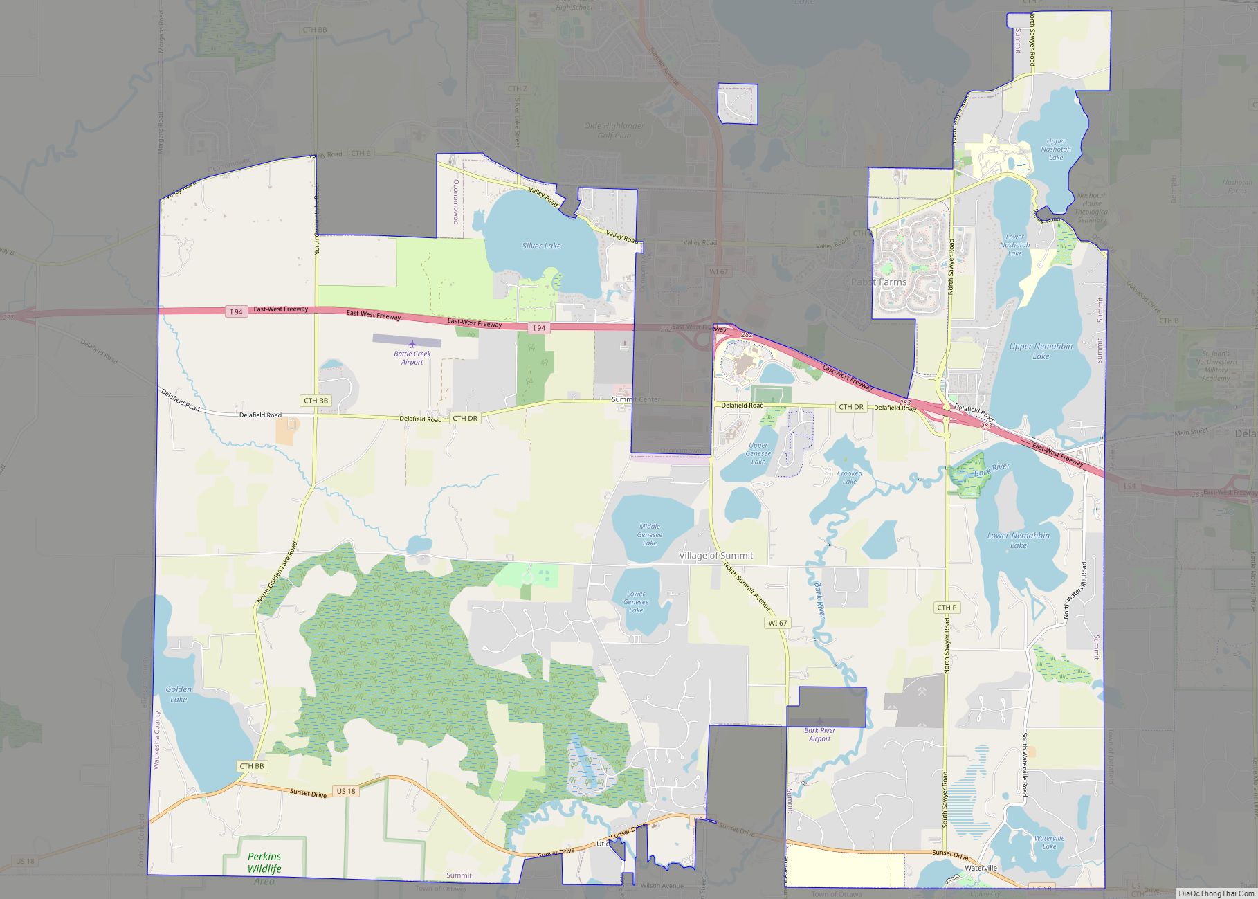
Map of Verona city, Wisconsin
Verona is a city in Dane County, Wisconsin, in the United States and is a suburb of Madison. The population was 14,030 at the 2020 census. The city is located ten miles southwest of downtown Madison within the Town of Verona. It is part of the Madison Metropolitan Statistical Area. Verona city overview: Name: Verona ... Read more
Map of Verona city, Wisconsin
Map of Tustin CDP, Wisconsin
Tustin is a census-designated place in the Town of Bloomfield, Waushara County, Wisconsin, United States. Its population was 117 as of the 2010 census. Tustin is located on the northern shore of Lake Poygan. Tustin CDP overview: Name: Tustin CDP LSAD Code: 57 LSAD Description: CDP (suffix) State: Wisconsin County: Waushara County Elevation: 751 ft (229 m) ... Read more
Map of Tustin CDP, Wisconsin
Map of Tunnel City CDP
Tunnel City is an unincorporated census-designated place in the town of Greenfield, Monroe County, Wisconsin, United States, named after the train tunnel through a hill just to the west of town. Tunnel City CDP overview: Name: Tunnel City CDP LSAD Code: 57 LSAD Description: CDP (suffix) State: Wisconsin County: Monroe County Elevation: 320 m (1,060 ft) Total ... Read more
Map of Tunnel City CDP
Map of Wabeno CDP
Wabeno is an unincorporated census-designated place located within the town of Wabeno, in Forest County, Wisconsin, United States. It is located on Wisconsin Highway 32 at the eastern terminus of Wisconsin Highway 52 within the Nicolet National Forest. As of the 2010 census, its population is 575. Wabeno CDP overview: Name: Wabeno CDP LSAD Code: ... Read more
Map of Wabeno CDP
Map of Trego CDP, Wisconsin
Trego (also Mills, Superior Junction) is an unincorporated census-designated place located in the town of Trego, Washburn County, Wisconsin, United States. Trego is located at the junction of U.S. Highway 53 and U.S. Highway 63, 6 miles (9.7 km) north-northeast of Spooner. Trego has a post office with ZIP code 54888. As of the 2010 census, ... Read more
Map of Trego CDP, Wisconsin
Map of Viroqua city
Viroqua is the county seat of Vernon County, Wisconsin, United States. The population was 4,504 at the 2020 census. The city is in the town of Viroqua. Viroqua city overview: Name: Viroqua city LSAD Code: 25 LSAD Description: city (suffix) State: Wisconsin County: Vernon County Total Area: 4.36 sq mi (11.29 km²) Land Area: 4.36 sq mi (11.29 km²) Water Area: ... Read more
Map of Viroqua city
Map of Tony village
Tony is a village in Rusk County, Wisconsin, United States. The population was 113 at the 2010 census. Tony village overview: Name: Tony village LSAD Code: 47 LSAD Description: village (suffix) State: Wisconsin County: Rusk County Elevation: 1,230 ft (370 m) Total Area: 2.02 sq mi (5.24 km²) Land Area: 2.02 sq mi (5.24 km²) Water Area: 0.00 sq mi (0.00 km²) Total Population: 113 Population ... Read more
Map of Tony village
Map of Washburn city, Wisconsin
Washburn is a city in Bayfield County, in the U.S. state of Wisconsin. The population was 2,051 at the 2020 census. The city is just east of and adjacent to the Town of Washburn. It is in northern Wisconsin, on the shore of Lake Superior’s Chequamegon Bay. Wisconsin Highway 13 and County Highway C are ... Read more
Map of Washburn city, Wisconsin
Map of Wautoma city
Wautoma is a city in Waushara County, Wisconsin, United States. The population was 2,218 at the 2010 census. Wautoma is the county seat of Waushara County. The city consists of three noncontiguous areas: one is entirely within the Town of Wautoma, the second is entirely within the Town of Dakota, and the third straddles the ... Read more
Map of Wautoma city
Map of Wales village, Wisconsin
Wales is a village in Waukesha County, Wisconsin, first settled by Welsh immigrants. The population was 2,862 at the time of the 2020 census. Wales village overview: Name: Wales village LSAD Code: 47 LSAD Description: village (suffix) State: Wisconsin County: Waukesha County Elevation: 1,001 ft (305 m) Total Area: 3.23 sq mi (8.37 km²) Land Area: 3.23 sq mi (8.36 km²) Water Area: ... Read more
Map of Wales village, Wisconsin
Map of Whitelaw village
Whitelaw is a village in Manitowoc County, Wisconsin, United States. The population was 737 at the 2020 census. Whitelaw village overview: Name: Whitelaw village LSAD Code: 47 LSAD Description: village (suffix) State: Wisconsin County: Manitowoc County Elevation: 856 ft (261 m) Total Area: 0.53 sq mi (1.37 km²) Land Area: 0.53 sq mi (1.36 km²) Water Area: 0.01 sq mi (0.01 km²) Total Population: 737 Population ... Read more
Map of Whitelaw village
Map of Wisconsin Dells city
Wisconsin Dells is a city in Wisconsin, straddling four counties: Adams, Columbia, Juneau, and Sauk. A popular Midwestern tourist destination, the city forms an area known as “The Dells” with the nearby village of Lake Delton. The Dells is home to several water parks and tourist attractions. The city takes its name from the Dells ... Read more
Map of Wisconsin Dells city