Map of Vilas town, Colorado
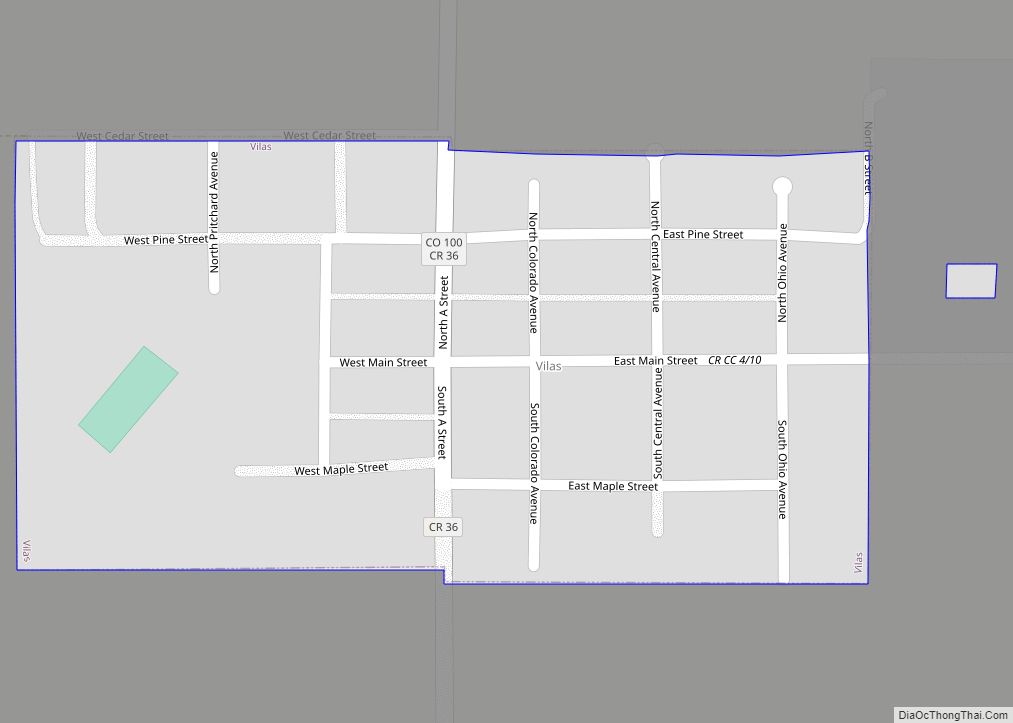
The town of Vilas is a statutory town located in Baca County, Colorado, United States. The population was 98 at the 2020 census. A post office called Vilas has been in operation since 1887. The community was named after William Freeman Vilas, a United States Senator from Wisconsin. Vilas town overview: Name: Vilas town LSAD ... Read more
Map of Vilas town, Colorado
Map of Victor city, Colorado
The City of Victor is a Statutory City in Teller County, Colorado, United States. Gold was discovered in Victor in the late 19th century, an omen of the future of the town. With Cripple Creek, the mining district became the second largest gold mining district in the country and realized approximately $10 billion of mined ... Read more
Map of Victor city, Colorado
Map of Walsenburg city
Walsenburg is the Statutory City that is the county seat and the most populous municipality of Huerfano County, Colorado, United States. The city population was 3,049 at the 2020 census, down from 3,068 in 2010. Walsenburg city overview: Name: Walsenburg city LSAD Code: 25 LSAD Description: city (suffix) State: Colorado County: Huerfano County Incorporated: June ... Read more
Map of Walsenburg city
Map of Walden town, Colorado
Walden is the Statutory Town that is the county seat, the most populous community, and the only incorporated municipality in Jackson County, Colorado, United States. It is situated in the center of a large open valley called North Park. People from Walden and the surrounding area refer to themselves as “North Parkers”. The town population ... Read more
Map of Walden town, Colorado
Map of Vona town
Vona is a statutory town in Kit Carson County, Colorado, United States. The population was 95 at the 2020 census. Vona town overview: Name: Vona town LSAD Code: 43 LSAD Description: town (suffix) State: Colorado County: Kit Carson County Incorporated: August 9, 1919 Elevation: 4,514 ft (1,376 m) Total Area: 0.22 sq mi (0.57 km²) Land Area: 0.22 sq mi (0.57 km²) Water ... Read more
Map of Vona town
Map of Watkins CDP, Colorado
Watkins (also called Box Elder) is an unincorporated town and a census-designated place (CDP) located in and governed by Arapahoe and Adams counties, Colorado, United States. The CDP is a part of the Denver–Aurora–Lakewood, CO Metropolitan Statistical Area. The town is surrounded by Aurora and its post office, which lies within the Aurora city limits, ... Read more
Map of Watkins CDP, Colorado
Map of Ward town, Colorado
Ward is a home rule municipality in Boulder County, Colorado, United States. The population was 150 at the 2010 census. The town is a former mining settlement founded in 1860 in the wake of the discovery of gold at nearby Gold Hill. Once one of the richest towns in the state during the Colorado Gold ... Read more
Map of Ward town, Colorado
Map of Walsh town
Walsh is a Statutory Town in Baca County, Colorado, United States. The population was 543 at the 2020 census. A post office called Walsh has been in operation since 1926. The community was named after one Mr. Walsh, a railroad official. Walsh town overview: Name: Walsh town LSAD Code: 43 LSAD Description: town (suffix) State: ... Read more
Map of Walsh town
Map of Wellington town, Colorado
Wellington is a statutory town in Larimer County, Colorado, United States. The population was 11,047 at the 2020 census. Wellington town overview: Name: Wellington town LSAD Code: 43 LSAD Description: town (suffix) State: Colorado County: Larimer County Founded: 1902 Incorporated: November 10, 1905 Elevation: 5,200 ft (1,585 m) Total Area: 3.63 sq mi (9.41 km²) Land Area: 3.63 sq mi (9.40 km²) Water ... Read more
Map of Wellington town, Colorado
Map of Weldona CDP
Weldona is an unincorporated town, a post office, and a census-designated place (CDP) located in and governed by Morgan County, Colorado, United States. The CDP is a part of the Fort Morgan, CO Micropolitan Statistical Area. The Weldona post office has the ZIP Code 80653. At the United States Census 2020, the population of the ... Read more
Map of Weldona CDP
Map of Welby CDP
Welby is an unincorporated community and a census-designated place (CDP) located in and governed by Adams County, Colorado, United States. The CDP is a part of the Denver–Aurora–Lakewood, CO Metropolitan Statistical Area. The population of the Welby CDP was 15,553 at the United States Census 2020. Welby CDP overview: Name: Welby CDP LSAD Code: 57 ... Read more
Map of Welby CDP
Map of Westcreek CDP
Westcreek is an unincorporated community and a census-designated place (CDP) located in and governed by Douglas County, Colorado, United States. The CDP is a part of the Denver–Aurora–Lakewood, CO Metropolitan Statistical Area. The population of the Westcreek CDP was 120 at the United States Census 2020. The Sedalia post office (Zip Code 80135) serves the ... Read more
Map of Westcreek CDP