Map of Westcliffe town
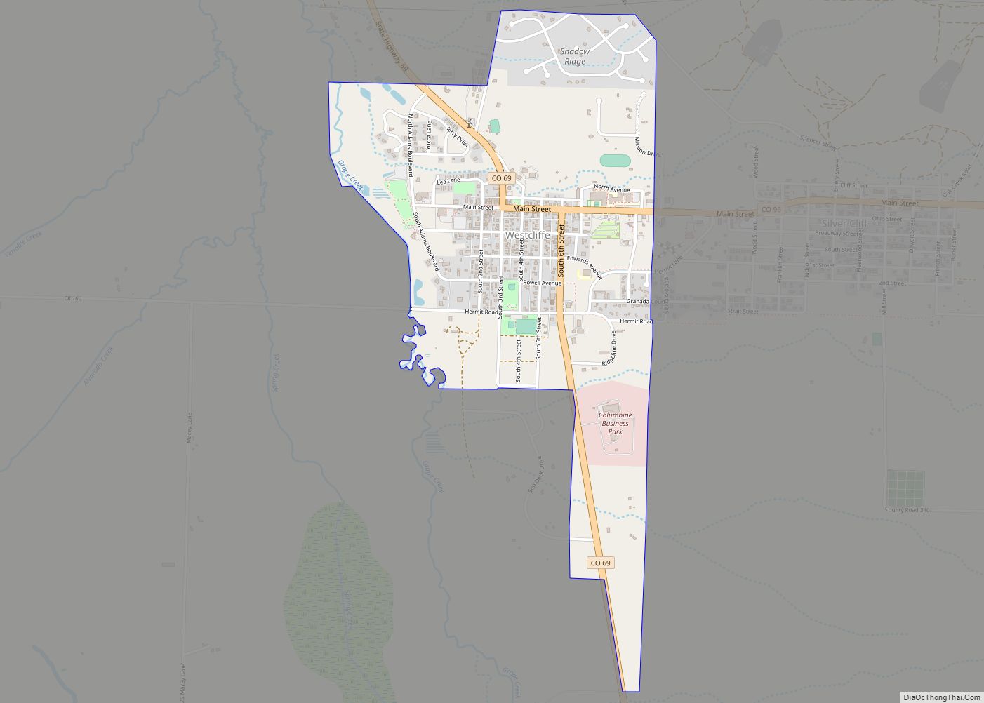
Westcliffe is a statutory town that is the county seat of Custer County, Colorado, United States. At the 2020 U.S. Census, the population was 435. Westcliffe town overview: Name: Westcliffe town LSAD Code: 43 LSAD Description: town (suffix) State: Colorado County: Custer County Incorporated: November 21, 1887 Elevation: 7,867 ft (2,398 m) Total Area: 1.24 sq mi (3.20 km²) Land ... Read more
Map of Westcliffe town
Map of West Pleasant View CDP
West Pleasant View is an unincorporated community and a census-designated place (CDP) located in and governed by Jefferson County, Colorado, United States. The CDP is a part of the Denver–Aurora–Lakewood, CO Metropolitan Statistical Area. The population of the West Pleasant View CDP was 4,327 at the United States Census 2020. The Pleasant View Metropolitan District ... Read more
Map of West Pleasant View CDP
Map of Wiggins town, Colorado
Wiggins is a statutory town in Morgan County, Colorado, United States. The population was 1,401 as of the 2020 census, up from 893 at the 2010 census. The community was established in 1882 as the Burlington Railroad depot of “Corona”. Around 1900, Corona was renamed in honor of Oliver P. Wiggins, who had served as ... Read more
Map of Wiggins town, Colorado
Map of Wheat Ridge city
The City of Wheat Ridge is a home rule municipality located in Jefferson County, Colorado, United States. Wheat Ridge is located immediately west of Denver and is a part of the Denver–Aurora–Lakewood, CO Metropolitan Statistical Area. The Wheat Ridge Municipal Center is approximately 5 miles (8 km) west-northwest of the Colorado State Capitol in Denver. The ... Read more
Map of Wheat Ridge city
Map of Weston CDP, Colorado
Weston is an unincorporated town, a post office, and a census-designated place (CDP) located in and governed by Las Animas County, Colorado, United States. The Weston post office has the ZIP Code 81091. At the United States Census 2020, the population of the Weston CDP was 53. Weston CDP overview: Name: Weston CDP LSAD Code: ... Read more
Map of Weston CDP, Colorado
Map of Windsor town, Colorado
Windsor is a home rule municipality in Larimer and Weld counties in the U.S. state of Colorado. According to the 2020 census, the population of the town was 32,716. Windsor is located in the Northern Colorado region. Windsor town overview: Name: Windsor town LSAD Code: 43 LSAD Description: town (suffix) State: Colorado County: Larimer County, ... Read more
Map of Windsor town, Colorado
Map of Williamsburg town, Colorado
Williamsburg is a statutory town located in Fremont County, Colorado, United States. The town population was 731 at the 2020 census. The Florence post office (ZIP code 81226) serves Williamsburg. Williamsburg town overview: Name: Williamsburg town LSAD Code: 43 LSAD Description: town (suffix) State: Colorado County: Fremont County Incorporated: April 7, 1888 Elevation: 5,390 ft (1,643 m) ... Read more
Map of Williamsburg town, Colorado
Map of Wiley town
Wiley is a Statutory Town in Prowers County, Colorado, United States. The population was 437 at the 2020 Census. Wiley town overview: Name: Wiley town LSAD Code: 43 LSAD Description: town (suffix) State: Colorado County: Prowers County Incorporated: January 28, 1909 Elevation: 3,747 ft (1,142 m) Total Area: 0.31 sq mi (0.81 km²) Land Area: 0.31 sq mi (0.81 km²) Water Area: 0.00 sq mi ... Read more
Map of Wiley town
Map of Woodland Park city, Colorado
Woodland Park is a home rule municipality in Teller County, Colorado, United States. Woodland Park is part of the Colorado Springs, CO Metropolitan Statistical Area. Many residents in this bedroom community commute to Colorado Springs. Woodland Park is surrounded by the 1,000,000-acre (400,000 ha) Pike National Forest. The population was 7,920 as of the 2020 Census. ... Read more
Map of Woodland Park city, Colorado
Map of Wolcott CDP, Colorado
Wolcott is an unincorporated town, a post office, and a census-designated place (CDP) located in and governed by Eagle County, Colorado, United States. The CDP is a part of the Edwards, CO Micropolitan Statistical Area. The Wolcott post office has the ZIP Code 81655 (post office boxes). At the United States Census 2020, the population ... Read more
Map of Wolcott CDP, Colorado
Map of Winter Park town, Colorado
Winter Park is a home rule municipality in Grand County, Colorado, United States. The permanent population was 1,033 at the 2020 census, although with 2,572 housing units within the town limits the seasonal population can be much higher. It is home to Winter Park Resort, a ski resort owned by the City of Denver and ... Read more
Map of Winter Park town, Colorado
Map of Wray city
Wray (/ˈreɪ/) is the home rule municipality that is the county seat of Yuma County, Colorado, United States. Located in the Colorado Plains, the city is 170 miles east of Denver, 9 miles west of the Nebraska state line, and 25 miles northwest of the Kansas state line. The population was 2,358 at the 2020 ... Read more
Map of Wray city