Map of Lake Mary Jane CDP
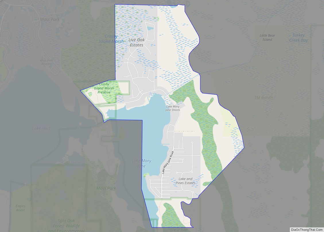
Lake Mary is a census-designated place and unincorporated area in Orange County, Florida, United States. The population was 1,575 at the 2010 census. It is part of the Orlando–Kissimmee Metropolitan Statistical Area. Lake Mary Jane CDP overview: Name: Lake Mary Jane CDP LSAD Code: 57 LSAD Description: CDP (suffix) State: Florida County: Orange County Elevation: ... Read more
Map of Lake Mary Jane CDP
Map of Lake Magdalene CDP
Lake Magdalene is a census-designated place (CDP) in Hillsborough County, Florida, United States. The population was 28,509 at the 2010 census. Lake Magdalene CDP overview: Name: Lake Magdalene CDP LSAD Code: 57 LSAD Description: CDP (suffix) State: Florida County: Hillsborough County Elevation: 46 ft (14 m) Total Area: 11.61 sq mi (30.07 km²) Land Area: 10.20 sq mi (26.42 km²) Water Area: 1.41 sq mi ... Read more
Map of Lake Magdalene CDP
Map of Lake Park town, Florida
Lake Park is a town in Palm Beach County, Florida, United States. The population was 8,155 at the 2010 census. As of 2018, the population recorded by the U.S. Census Bureau was 8,605. Lake Park is part of the Miami Metropolitan Area Lake Park town overview: Name: Lake Park town LSAD Code: 43 LSAD Description: ... Read more
Map of Lake Park town, Florida
Map of Lake Panasoffkee CDP
Lake Panasoffkee is a census-designated place (CDP) in Sumter County, Florida, United States. The population was 3,551 at the 2010 census. Lake Panasoffkee CDP overview: Name: Lake Panasoffkee CDP LSAD Code: 57 LSAD Description: CDP (suffix) State: Florida County: Sumter County Elevation: 59 ft (18 m) Total Area: 6.60 sq mi (17.10 km²) Land Area: 4.30 sq mi (11.14 km²) Water Area: 2.30 sq mi ... Read more
Map of Lake Panasoffkee CDP
Map of Lake Mystic CDP
Lake Mystic is an unincorporated community and census-designated place in Liberty County, Florida, United States. Its population was 500 at the 2010 census. Lake Mystic CDP overview: Name: Lake Mystic CDP LSAD Code: 57 LSAD Description: CDP (suffix) State: Florida County: Liberty County Elevation: 138 ft (42 m) Total Area: 4.708 sq mi (12.19 km²) Land Area: 4.538 sq mi (11.75 km²) Water ... Read more
Map of Lake Mystic CDP
Map of Lake Wales city
Lake Wales is a city in Polk County, Florida. The population was 14,225 at the 2010 census. As of 2019, the population estimated by the U.S. Census Bureau is 16,759. It is part of the Lakeland–Winter Haven Metropolitan Statistical Area. Lake Wales is located in central Florida, west of Lake Kissimmee and east of Tampa. ... Read more
Map of Lake Wales city
Map of Lake Sarasota CDP
Lake Sarasota is a census-designated place (CDP) in Sarasota County, Florida, United States. The population was 4,679 at the 2010 census. It is part of the North Port–Sarasota–Bradenton Metropolitan Statistical Area. Lake Sarasota CDP overview: Name: Lake Sarasota CDP LSAD Code: 57 LSAD Description: CDP (suffix) State: Florida County: Sarasota County Elevation: 30 ft (9 m) Total ... Read more
Map of Lake Sarasota CDP
Map of Lake Placid town, Florida
Lake Placid is a town in Highlands County, Florida, United States. As of the 2010 census the population was 2,223 and in 2018 the estimated population was 2,439. It is part of the Sebring Metropolitan Statistical Area. The town has two nicknames: “Town of Murals” and “The Caladium Capital of the World”. Lake Placid has ... Read more
Map of Lake Placid town, Florida
Map of Lakeside CDP, Florida
Lakeside is an unincorporated area and census-designated place in Clay County, Florida, United States. The population was 30,943 at the 2010 census. It is part of the greater Orange Park area. Lakeside CDP overview: Name: Lakeside CDP LSAD Code: 57 LSAD Description: CDP (suffix) State: Florida County: Clay County Elevation: 66 ft (20 m) Total Area: 15.65 sq mi ... Read more
Map of Lakeside CDP, Florida
Map of Lakeland Highlands CDP
Lakeland Highlands is an unincorporated community and census-designated place (CDP) in Polk County, Florida, United States. The population was 11,056 at the 2010 census. It is part of the Lakeland–Winter Haven Metropolitan Statistical Area. It is an affluent residential community located south of the Lakeland city limits, and north of the Mulberry city limits. Lakeland ... Read more
Map of Lakeland Highlands CDP
Map of Lake Worth city, Florida
Lake Worth city overview: Name: Lake Worth city LSAD Code: 25 LSAD Description: city (suffix) State: Florida County: Palm Beach County FIPS code: 1239075 Online Interactive Map Lake Worth online map. Source: Basemap layers from Google Map, Open Street Map (OSM), Arcgisonline, Wmflabs. Boundary Data from Database of Global Administrative Areas. Lake Worth location map. ... Read more
Map of Lake Worth city, Florida
Map of Land O’ Lakes CDP
Land o’ Lakes is a census-designated place (CDP) in Pasco County, Florida, United States. Land o’ Lakes is part of the Tampa-St. Petersburg-Clearwater, Florida MSA. As of the 2010 census, the CDP population was 31,145. The CDP grew rapidly during the 1990s, growing from 7,800 residents to 20,971 as new housing developments were built. Average ... Read more
Map of Land O’ Lakes CDP