Map of Springhill CDP, Florida
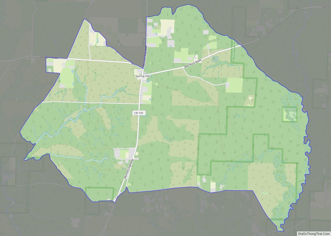
Spring Hill (also known as Springhill) is an unincorporated community and census-designated place in Santa Rosa County, Florida, United States. Its population was 160 as of the 2010 census. Springhill CDP overview: Name: Springhill CDP LSAD Code: 57 LSAD Description: CDP (suffix) State: Florida County: Santa Rosa County Elevation: 200 ft (60 m) Total Area: 12.523 sq mi (32.43 km²) ... Read more
Map of Springhill CDP, Florida
Map of Springfield city, Florida
Springfield is a city in Bay County, Florida, United States, east of Panama City. The population was 8,903 at the 2010 census. It is part of the Panama City–Lynn Haven–Panama City Beach Metropolitan Statistical Area. Springfield was incorporated on February 12, 1935. Unlike much of Bay County, Springfield has been mostly left out of the ... Read more
Map of Springfield city, Florida
Map of St. Cloud city, Florida
St. Cloud or Saint Cloud is a city in northern Osceola County, Florida, United States. It is on the southern shore of East Lake Tohopekaliga in Central Florida, about 26 miles (41.8 km) southeast of Orlando. The population was 35,183 in the 2010 census, and 54,579 in the 2019 census estimate. The city is part of ... Read more
Map of St. Cloud city, Florida
Map of St. Augustine South CDP
St. Augustine South is a census-designated place (CDP) in St. Johns County, Florida, United States. The population was 5,035 at the 2000 census. St. Augustine South CDP overview: Name: St. Augustine South CDP LSAD Code: 57 LSAD Description: CDP (suffix) State: Florida County: St. Johns County Elevation: 30 ft (9 m) Total Area: 1.58 sq mi (4.11 km²) Land Area: ... Read more
Map of St. Augustine South CDP
Map of St. Augustine Shores CDP
St. Augustine Shores is a census-designated place (CDP) in St. Johns County, Florida, United States. As of the 2000 census, the CDP population was 4,922. St. Augustine Shores CDP overview: Name: St. Augustine Shores CDP LSAD Code: 57 LSAD Description: CDP (suffix) State: Florida County: St. Johns County Elevation: 26 ft (8 m) Total Area: 4.48 sq mi (11.60 km²) ... Read more
Map of St. Augustine Shores CDP
Map of St. George Island CDP, Florida
St. George Island is an island and Census-designated place (CDP) off the Florida Panhandle in the northern Gulf of Mexico. It is in Franklin County, Florida, United States. St. George Island CDP overview: Name: St. George Island CDP LSAD Code: 57 LSAD Description: CDP (suffix) State: Florida ZIP code: 32328 Area code: 850 FIPS code: ... Read more
Map of St. George Island CDP, Florida
Map of St. Leo town, Florida
St. Leo is a town in Pasco County, Florida, United States. It is a suburb included in the Tampa-St. Petersburg-Clearwater, Florida Metropolitan Statistical Area. The population was 1,340 at the 2010 census. It is best known as the home of St. Leo University, Holy Name Monastery and St. Leo Abbey. Vincent D’Ambrosio currently serves as ... Read more
Map of St. Leo town, Florida
Map of St. James City CDP
St. James City is an unincorporated community and census-designated place (CDP) on Pine Island in Lee County, Florida, United States. The population was 3,876 at the 2020 census, up from 3,784 at the 2010 census. It is part of the Cape Coral-Fort Myers, Florida Metropolitan Statistical Area. St. James City CDP overview: Name: St. James ... Read more
Map of St. James City CDP
Map of St. Pete Beach city
St. Pete Beach (formerly called St. Petersburg Beach) is a coastal city in Pinellas County, Florida. Known as a tourist destination, St. Pete Beach was formed from the towns of Pass-a-Grille, Belle Vista, St. Petersburg Beach and unincorporated Pinellas County.The population was 9,346 at the 2010 census. St. Pete Beach’s downtown is centered on Corey ... Read more
Map of St. Pete Beach city
Map of St. Marks city
St. Marks is a city in Wakulla County, Florida, United States. It is part of the Tallahassee metropolitan area. The population was 293 at the 2010 census. As of 2018, the population estimated by the U.S. Census Bureau is 319. St. Marks city overview: Name: St. Marks city LSAD Code: 25 LSAD Description: city (suffix) ... Read more
Map of St. Marks city
Map of St. Lucie Village town
The Town of St. Lucie Village is a town in St. Lucie County, Florida, United States. The population was 590 at the 2010 census. It is part of the Port St. Lucie Metropolitan Statistical Area. St. Lucie Village was incorporated in 1961 and includes the St. Lucie Village Historic District. St. Lucie Village town overview: ... Read more
Map of St. Lucie Village town
Map of Steinhatchee CDP
Steinhatchee (/ˈstiːnhætʃi/ (listen) STEEN-hatch-ee) is a Gulf coastal community in the southern part of Taylor County, Florida, United States. Steinhatchee is 38 miles (61 km) south of the county seat of Perry. Just across the Steinhatchee River is Jena, which is in Dixie County. Steinhatchee is 19.27 miles north of the town of Cross City. The ... Read more
Map of Steinhatchee CDP