Map of The Acreage CDP
The Acreage is an unincorporated community located in Palm Beach County, Florida, United States, with a 2010 US Census Bureau population count of 38,704. It is located in the areas north of Royal Palm Beach and Loxahatchee Groves, and is approximately 18 miles (29 km) northwest of West Palm Beach. Most of the population lives in ... Read more
Map of The Acreage CDP
Map of Tequesta village
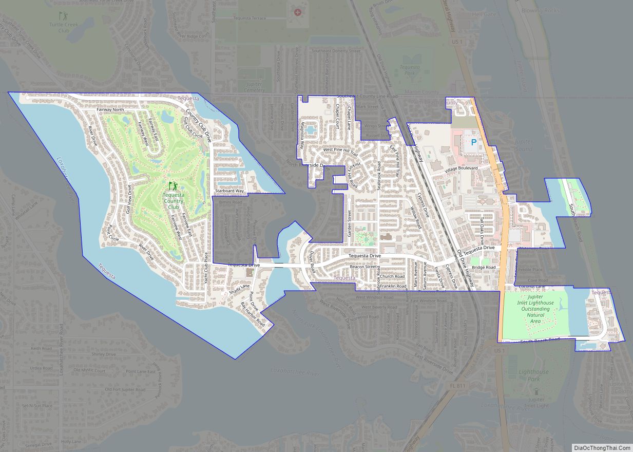
Tequesta is an incorporated village in Palm Beach County, Florida, United States. The population was 6,158 at the 2020 Census. It is the northernmost municipality in the Miami metropolitan area, which in 2010 had a total population of 5,564,635 according to the U.S. Census. Tequesta village overview: Name: Tequesta village LSAD Code: 47 LSAD Description: ... Read more
Map of Tequesta village
Map of The Villages CDP
The Villages is a census-designated place (CDP) in Sumter and Marion counties, Florida, United States. It shares its name with a broader master-planned age-restricted community that spreads into portions of Lake County. The overall development lies in central Florida, approximately 20 miles (32 km) south of Ocala and approximately 45 miles (72 km) northwest of Orlando. As ... Read more
Map of The Villages CDP
Map of The Meadows CDP
The Meadows is a census-designated place (CDP) in Sarasota County, Florida, United States. The population was 3,994 at the 2010 census. The CDP is part of the Bradenton–Sarasota–Venice Metropolitan Statistical Area. The Meadows CDP overview: Name: The Meadows CDP LSAD Code: 57 LSAD Description: CDP (suffix) State: Florida County: Sarasota County Elevation: 26 ft (8 m) Total ... Read more
Map of The Meadows CDP
Map of The Hammocks CDP
The Hammocks is a planned community and census-designated place in Miami-Dade County, Florida, United States. The population was 59,480 at the 2020 census, up from 51,003 in 2010. The Hammocks CDP overview: Name: The Hammocks CDP LSAD Code: 57 LSAD Description: CDP (suffix) State: Florida County: Miami-Dade County Elevation: 8 ft (2 m) Land Area: 7.89 sq mi (20.43 km²) ... Read more
Map of The Hammocks CDP
Map of Three Oaks CDP, Florida
Three Oaks is a census-designated place (CDP) in Lee County, Florida, United States. The population was 3,592 at the 2010 census, up from 2,255 at the 2000 census. It is part of the Cape Coral-Fort Myers, Florida Metropolitan Statistical Area. Three Oaks CDP overview: Name: Three Oaks CDP LSAD Code: 57 LSAD Description: CDP (suffix) ... Read more
Map of Three Oaks CDP, Florida
Map of Three Lakes CDP, Florida
Three Lakes is a census-designated place (CDP) in Miami-Dade County, Florida, United States. The population was 16,540 at the 2020 census, up from 15,047 in 2010. Its name comes from the planned community of Three Lakes, which is located inside Three Lakes CDP boundaries. Three Lakes CDP overview: Name: Three Lakes CDP LSAD Code: 57 ... Read more
Map of Three Lakes CDP, Florida
Map of Thonotosassa CDP
Thonotosassa is a census-designated place (CDP) in Hillsborough County, Florida, United States. The population was 15,238 at the 2020 census, up from 13,014 at the 2010 census. Thonotosassa CDP overview: Name: Thonotosassa CDP LSAD Code: 57 LSAD Description: CDP (suffix) State: Florida County: Hillsborough County Elevation: 33 ft (10 m) Total Area: 28.33 sq mi (73.37 km²) Land Area: 26.48 sq mi ... Read more
Map of Thonotosassa CDP
Map of Tiger Point CDP
Tiger Point is a census-designated place in Santa Rosa County, Florida. It is considered to be a part of Gulf Breeze. The population was 3,090 as of the 2010 census. Tiger Point CDP overview: Name: Tiger Point CDP LSAD Code: 57 LSAD Description: CDP (suffix) State: Florida County: Santa Rosa County Elevation: 3 ft (0.9 m) Total ... Read more
Map of Tiger Point CDP
Map of Tierra Verde CDP, Florida
Tierra Verde is a census-designated place (CDP) in Pinellas County, Florida, United States. The population was 3,721 at the 2010 census. The community is located on an island near the entrance of Tampa Bay, and is connected by the bridges of the Pinellas Bayway to both St. Petersburg and St. Pete Beach. At the southern ... Read more
Map of Tierra Verde CDP, Florida
Map of Tice CDP
Tice is an unincorporated community and census-designated place (CDP) in Lee County, Florida, United States. As of the 2020 census, the CDP population was 4,853. It is part of the Cape Coral-Fort Myers, Florida Metropolitan Statistical Area. Tice CDP overview: Name: Tice CDP LSAD Code: 57 LSAD Description: CDP (suffix) State: Florida County: Lee County ... Read more
Map of Tice CDP
Map of Timber Pines CDP
Timber Pines is a census-designated place (CDP) in Hernando County, Florida, United States. The population was 5,386 at the 2010 census. Timber Pines CDP overview: Name: Timber Pines CDP LSAD Code: 57 LSAD Description: CDP (suffix) State: Florida County: Hernando County Elevation: 13 ft (4 m) Total Area: 2.28 sq mi (5.92 km²) Land Area: 2.20 sq mi (5.70 km²) Water Area: 0.09 sq mi ... Read more
Map of Timber Pines CDP