Map of Sweetwater city, Florida
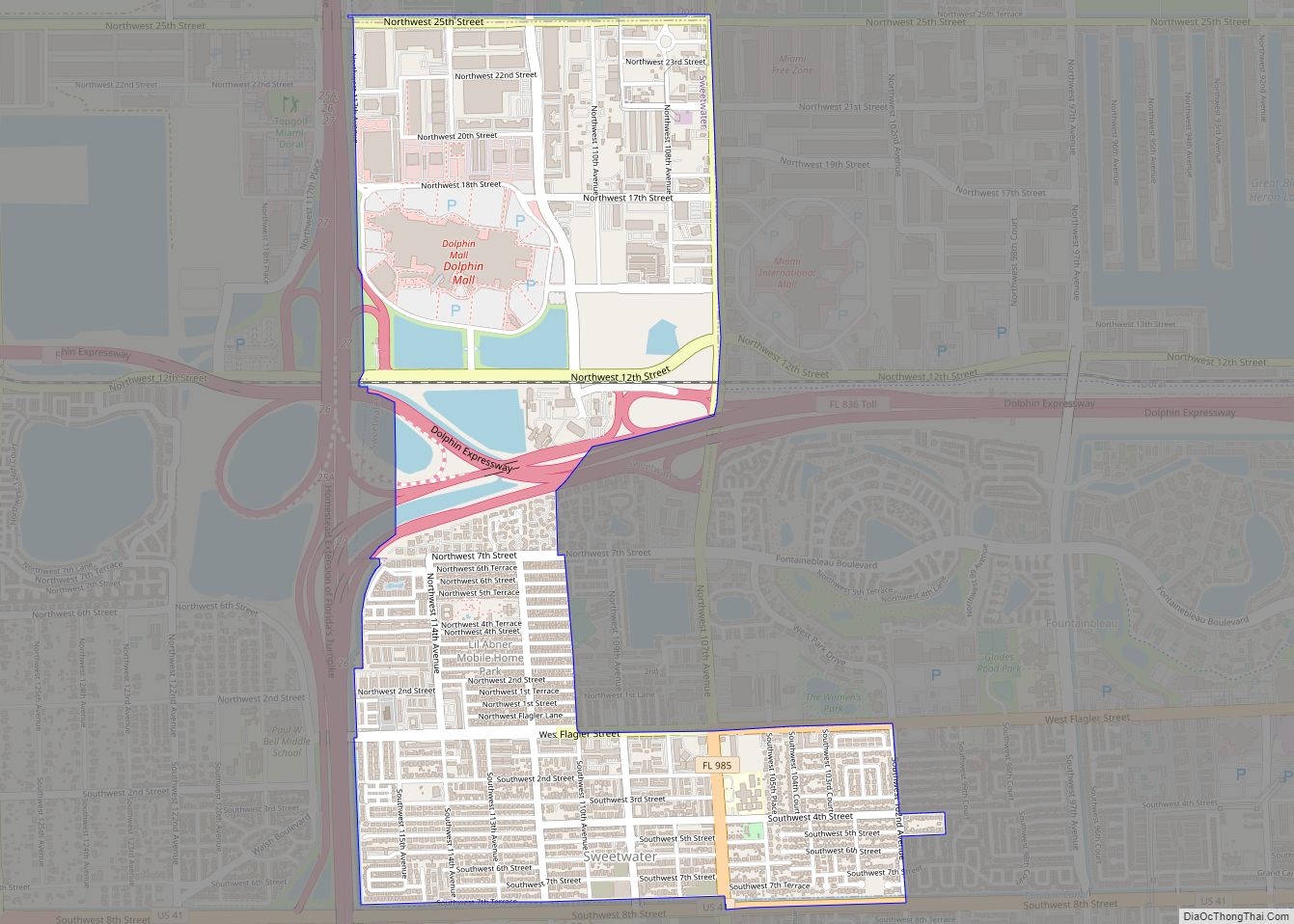
Sweetwater is a city in Miami-Dade County, Florida, United States. As of the 2020 census, the population was 19,363, up from 13,499 in 2010. Sweetwater city overview: Name: Sweetwater city LSAD Code: 25 LSAD Description: city (suffix) State: Florida County: Miami-Dade County Incorporated: October 10, 1941 Total Area: 2.30 sq mi (10.96 km²) Land Area: 2.19 sq mi (5.68 km²) Water ... Read more
Map of Sweetwater city, Florida
Map of Surfside town
Surfside is a town in Miami-Dade County, Florida, United States. The population was 5,689 as of the 2020 census. Surfside is a primarily residential beachside community, with several multistory condominium buildings adjacent to Surfside Beach on the Atlantic Ocean. The town is bordered on the south by the North Beach neighborhood of Miami Beach, on ... Read more
Map of Surfside town
Map of Tangelo Park CDP
Tangelo Park is a census-designated place and an unincorporated area in Orange County, Florida, United States. The population was 2,231 at the 2010 census. It is part of the Orlando–Kissimmee Metropolitan Statistical Area. Tangelo Park CDP overview: Name: Tangelo Park CDP LSAD Code: 57 LSAD Description: CDP (suffix) State: Florida County: Orange County Elevation: 95 ft ... Read more
Map of Tangelo Park CDP
Map of Tamiami CDP
Tamiami is a census-designated place (CDP) in Miami-Dade County, Florida, United States. The population was 54,212 at the 2020 census. Tamiami CDP overview: Name: Tamiami CDP LSAD Code: 57 LSAD Description: CDP (suffix) State: Florida County: Miami-Dade County Elevation: 7 ft (2 m) Total Area: 7.43 sq mi (19.24 km²) Land Area: 7.05 sq mi (18.25 km²) Water Area: 0.38 sq mi (0.98 km²) Total Population: ... Read more
Map of Tamiami CDP
Map of Tamarac city
Tamarac is a city in Broward County, Florida, United States. At the 2020 census, the city had a population of 71,897. It is part of the Miami metropolitan area, which was home to an estimated 6,012,331 people in 2015. Tamarac city overview: Name: Tamarac city LSAD Code: 25 LSAD Description: city (suffix) State: Florida County: ... Read more
Map of Tamarac city
Map of Tavares city
Tavares (/tʌvˈɛəriz/, tuh-VAIR-ees) is a city and the county seat of Lake County, Florida. The population at the 2020 census was 19,003, and in 2019 the population was estimated to be 17,749. It is part of the Orlando–Kissimmee–Sanford Metropolitan Statistical Area. Tavares city overview: Name: Tavares city LSAD Code: 25 LSAD Description: city (suffix) State: ... Read more
Map of Tavares city
Map of Tarpon Springs city
Tarpon Springs is a city in Pinellas County, Florida, United States. The population was 23,484 at the 2010 census. Downtown Tarpon Springs has long been a focal point and is undergoing beautification. Tarpon Springs has the highest percentage of Greek Americans of any city in the US. Tarpon Springs city overview: Name: Tarpon Springs city ... Read more
Map of Tarpon Springs city
Map of Tangerine CDP
Tangerine is a census-designated place (CDP) in Orange County, Florida, United States. The population was 2,865 at the 2010 census. It is part of the Orlando–Kissimmee Metropolitan Statistical Area. Tangerine CDP overview: Name: Tangerine CDP LSAD Code: 57 LSAD Description: CDP (suffix) State: Florida County: Orange County Elevation: 151 ft (46 m) Total Area: 5.29 sq mi (13.69 km²) Land ... Read more
Map of Tangerine CDP
Map of Taylor Creek CDP, Florida
Taylor Creek is a census-designated place (CDP) in Okeechobee County, Florida, United States. The population was 4,348 at the 2010 census. Taylor Creek CDP overview: Name: Taylor Creek CDP LSAD Code: 57 LSAD Description: CDP (suffix) State: Florida County: Okeechobee County Elevation: 16 ft (5 m) Total Area: 3.44 sq mi (8.91 km²) Land Area: 3.05 sq mi (7.89 km²) Water Area: 0.39 sq mi ... Read more
Map of Taylor Creek CDP, Florida
Map of Tavernier CDP
Tavernier is a census-designated place (CDP) and unincorporated community in Monroe County, Florida, United States on Key Largo, the largest island in the upper Florida Keys. Tavernier’s population was 2,530 at the 2020 census, up from 2,136 in 2010. Tavernier CDP overview: Name: Tavernier CDP LSAD Code: 57 LSAD Description: CDP (suffix) State: Florida County: ... Read more
Map of Tavernier CDP
Map of Temple Terrace city
Temple Terrace is an incorporated city in northeastern Hillsborough County, Florida, United States, adjacent to Tampa. As of the 2020 census, the city had a population of 26,690. It is the third and smallest incorporated municipality in Hillsborough County. (Tampa and Plant City are the others.) Incorporated in 1925, the community is known for its ... Read more
Map of Temple Terrace city
Map of The Crossings CDP
The Crossings is a census-designated place (CDP) and suburb of Miami in Miami-Dade County, Florida, United States. The population was 23,276 at the 2020 census. The CDP includes the neighborhoods of The Crossings, Devon Aire and Calusa. The Crossings CDP overview: Name: The Crossings CDP LSAD Code: 57 LSAD Description: CDP (suffix) State: Florida County: ... Read more
Map of The Crossings CDP