Map of New Albany city, Indiana
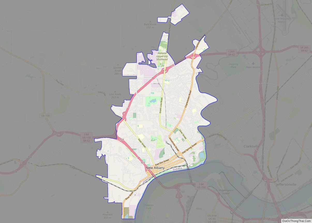
New Albany /ˈɑːlbəni/ is a city in Floyd County, Indiana, United States, situated along the Ohio River, opposite Louisville, Kentucky. The population was 37,841 as of the 2020 census. The city is the county seat of Floyd County. It is bounded by I-265 to the north and the Ohio River to the south, and is ... Read more
Map of New Albany city, Indiana
Map of Nashville town, Indiana
Nashville is a town in Washington Township, Brown County, Indiana, United States. The population was 803 at the 2010 census. The town is the county seat of Brown County and is the county’s only incorporated town. The town is best known as the center of the Brown County Art Colony and as a tourist destination. ... Read more
Map of Nashville town, Indiana
Map of New Castle city, Indiana
New Castle is a city in Henry County, Indiana, 44 miles (71 km) east-northeast of Indianapolis, on the Big Blue River. The city is the county seat of Henry County. New Castle is home to New Castle Fieldhouse, the largest high school gymnasium in the world. The city is surrounded by agricultural land. In the past, ... Read more
Map of New Castle city, Indiana
Map of New Carlisle town, Indiana
New Carlisle is a suburban village in Olive Township, St. Joseph County, in the U.S. state of Indiana. The population was 1,861 at the 2010 Census. It is part of the South Bend–Mishawaka, IN-MI, Metropolitan Statistical Area. New Carlisle town overview: Name: New Carlisle town LSAD Code: 43 LSAD Description: town (suffix) State: Indiana County: ... Read more
Map of New Carlisle town, Indiana
Map of New Chicago town
New Chicago is a town in Hobart Township, Lake County, Indiana, United States. The population was 2,035 at the 2010 census. New Chicago town overview: Name: New Chicago town LSAD Code: 43 LSAD Description: town (suffix) State: Indiana County: Lake County Elevation: 636 ft (194 m) Total Area: 0.69 sq mi (1.75 km²) Land Area: 0.69 sq mi (1.75 km²) Water Area: 0.00 sq mi ... Read more
Map of New Chicago town
Map of New Haven city, Indiana
New Haven is a city in Adams, Jefferson, and St. Joseph townships, Allen County, Indiana, United States. It sits to the east of the city of Fort Wayne, the second largest city in Indiana, and is situated mostly along the southern banks of the Maumee River. The population was 14,794 as of the 2010 census. ... Read more
Map of New Haven city, Indiana
Map of New Harmony town, Indiana
New Harmony is a historic town on the Wabash River in Harmony Township, Posey County, Indiana. It lies 15 miles (24 km) north of Mount Vernon, the county seat, and is part of the Evansville metropolitan area. The town’s population was 789 at the 2010 census. Established by the Harmony Society in 1814 under the leadership ... Read more
Map of New Harmony town, Indiana
Map of New Goshen CDP
New Goshen is a census-designated place (CDP) in Fayette Township, Vigo County, in the U.S. state of Indiana. It is part of the Terre Haute Metropolitan Statistical Area. New Goshen CDP overview: Name: New Goshen CDP LSAD Code: 57 LSAD Description: CDP (suffix) State: Indiana County: Vigo County Elevation: 643 ft (196 m) Total Area: 3.34 sq mi (8.64 km²) ... Read more
Map of New Goshen CDP
Map of New Palestine town
New Palestine (pronounced PAL-es-tēn) is a town in Sugar Creek Township, Hancock County, Indiana, along Sugar Creek. The population was 2,055 at the 2010 census. New Palestine town overview: Name: New Palestine town LSAD Code: 43 LSAD Description: town (suffix) State: Indiana County: Hancock County Elevation: 837 ft (255 m) Total Area: 1.99 sq mi (5.15 km²) Land Area: 1.98 sq mi ... Read more
Map of New Palestine town
Map of New Middletown town, Indiana
New Middletown is a town in Webster Township, Harrison County, Indiana, United States. The population was 93 at the 2010 census. New Middletown town overview: Name: New Middletown town LSAD Code: 43 LSAD Description: town (suffix) State: Indiana County: Harrison County Elevation: 699 ft (213 m) Total Area: 0.04 sq mi (0.09 km²) Land Area: 0.04 sq mi (0.09 km²) Water Area: 0.00 sq mi ... Read more
Map of New Middletown town, Indiana
Map of New Market town, Indiana
New Market is a town in Montgomery County, Indiana, in the United States. The population was 559 at the 2020 census, down from 636 in 2010. New Market town overview: Name: New Market town LSAD Code: 43 LSAD Description: town (suffix) State: Indiana County: Montgomery County Elevation: 807 ft (246 m) Total Area: 0.27 sq mi (0.71 km²) Land Area: ... Read more
Map of New Market town, Indiana
Map of New Point town
New Point is a town in Salt Creek Township, Decatur County, Indiana, United States. The population was 331 at the 2010 census. New Point town overview: Name: New Point town LSAD Code: 43 LSAD Description: town (suffix) State: Indiana County: Decatur County Total Area: 0.31 sq mi (0.81 km²) Land Area: 0.31 sq mi (0.81 km²) Water Area: 0.00 sq mi (0.00 km²) Total ... Read more
Map of New Point town