Map of Tecumseh CDP, Indiana
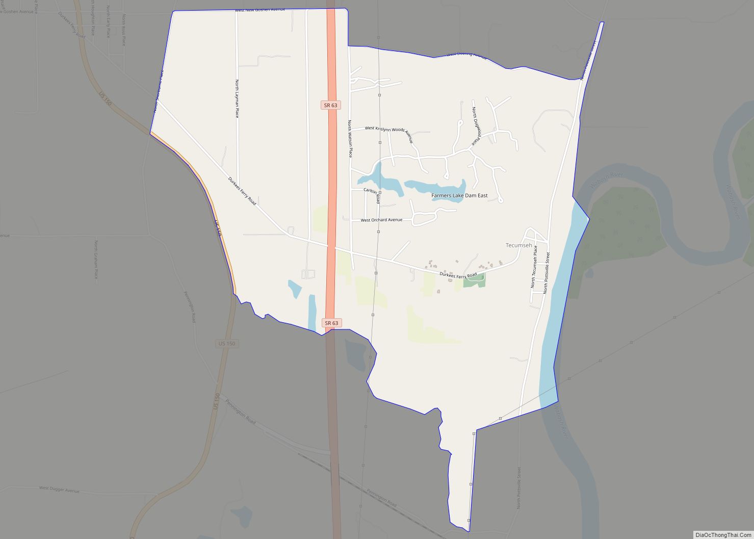
Tecumseh is an unincorporated census-designated place in eastern Fayette Township, Vigo County, in the U.S. state of Indiana. It is part of the Terre Haute metropolitan area. Tecumseh CDP overview: Name: Tecumseh CDP LSAD Code: 57 LSAD Description: CDP (suffix) State: Indiana County: Vigo County Elevation: 558 ft (170 m) Total Area: 3.55 sq mi (9.20 km²) Land Area: 3.48 sq mi ... Read more
Map of Tecumseh CDP, Indiana
Map of Taylorsville CDP, Indiana
Taylorsville is a census-designated place (CDP) in German Township, Bartholomew County, in the U.S. state of Indiana. The population was 919 at the 2010 census. It is part of the Columbus, Indiana metropolitan statistical area. Taylorsville CDP overview: Name: Taylorsville CDP LSAD Code: 57 LSAD Description: CDP (suffix) State: Indiana County: Bartholomew County Elevation: 653 ft ... Read more
Map of Taylorsville CDP, Indiana
Map of Thorntown town
Thorntown is a town in Sugar Creek Township, Boone County, Indiana. The population was 1,520 at the time of the 2010 census. Thorntown is located in northwestern Boone County, about halfway between Lafayette and Indianapolis. Thorntown town overview: Name: Thorntown town LSAD Code: 43 LSAD Description: town (suffix) State: Indiana County: Boone County Elevation: 856 ft ... Read more
Map of Thorntown town
Map of Terre Haute city
Terre Haute (/ˈtɛrə ˈhoʊt/ TERR-ə HOHT) is a city in and the county seat of Vigo County, Indiana, United States, about 5 miles east of the state’s western border with Illinois. As of the 2010 census, the city had a population of 60,785 and its metropolitan area had a population of 170,943. Located along the ... Read more
Map of Terre Haute city
Map of Tennyson town, Indiana
Tennyson is a town in Skelton Township, Warrick County, in the U.S. state of Indiana. The population was 279 at the 2010 census. Tennyson town overview: Name: Tennyson town LSAD Code: 43 LSAD Description: town (suffix) State: Indiana County: Warrick County Elevation: 404 ft (123 m) Total Area: 0.23 sq mi (0.61 km²) Land Area: 0.23 sq mi (0.61 km²) Water Area: 0.00 sq mi ... Read more
Map of Tennyson town, Indiana
Map of Topeka town, Indiana
Topeka is a town in Clearspring and Eden townships, LaGrange County, Indiana, United States. The population was 1,153 at the 2010 census. Topeka is located approximately eleven miles south of Shipshewana, Indiana. Topeka is home to Faron Yoder, the star of the Rumspringa documentary made in 2002 entitled “Devil’s Playground”. Topeka was likely so named ... Read more
Map of Topeka town, Indiana
Map of Toad Hop CDP
Toad Hop is an unincorporated census-designated place in Sugar Creek Township, Vigo County, in the U.S. state of Indiana. It is officially part of West Terre Haute. In 2010, Toad Hop was a census designated place. It is part of the Terre Haute metropolitan area. Toad Hop CDP overview: Name: Toad Hop CDP LSAD Code: ... Read more
Map of Toad Hop CDP
Map of Tipton city, Indiana
Tipton is a city in and the county seat of Tipton County, Indiana, United States. The population was estimated to be 5,275 as of July 1, 2021. Tipton city overview: Name: Tipton city LSAD Code: 25 LSAD Description: city (suffix) State: Indiana County: Tipton County Elevation: 869 ft (265 m) Total Area: 2.63 sq mi (6.80 km²) Land Area: 2.63 sq mi ... Read more
Map of Tipton city, Indiana
Map of Trail Creek town
Trail Creek is a town in Coolspring and Michigan townships, LaPorte County, Indiana, United States. The population was 2,052 at the 2010 census. It is included in the Michigan City, Indiana–La Porte, Indiana Metropolitan Statistical Area. Trail Creek town overview: Name: Trail Creek town LSAD Code: 43 LSAD Description: town (suffix) State: Indiana County: LaPorte ... Read more
Map of Trail Creek town
Map of Trafalgar town
Trafalgar is a town in Nineveh and Hensley townships, Johnson County, Indiana, United States. The population was 1,101 at the 2010 census. This town is 20 miles (32 km) south of Indianapolis. It is the home of the transmitters for WTTV, WTTS, WSOM and WHZN. Trafalgar town overview: Name: Trafalgar town LSAD Code: 43 LSAD Description: ... Read more
Map of Trafalgar town
Map of Town of Pines town
Town of Pines is a town in Pine Township, Porter County, in the U.S. state of Indiana. The population was 708 at the 2010 census. Town of Pines town overview: Name: Town of Pines town LSAD Code: 43 LSAD Description: town (suffix) State: Indiana County: Porter County Elevation: 627 ft (191 m) Total Area: 2.25 sq mi (5.84 km²) Land ... Read more
Map of Town of Pines town
Map of Ulen town, Indiana
Ulen is a town in Center Township, Boone County, in the U.S. state of Indiana. The population was 117 at the 2010 census. The town is surrounded by the city of Lebanon. Ulen town overview: Name: Ulen town LSAD Code: 43 LSAD Description: town (suffix) State: Indiana County: Boone County Elevation: 942 ft (287 m) Total Area: ... Read more
Map of Ulen town, Indiana