Map of Wolcott town, Indiana
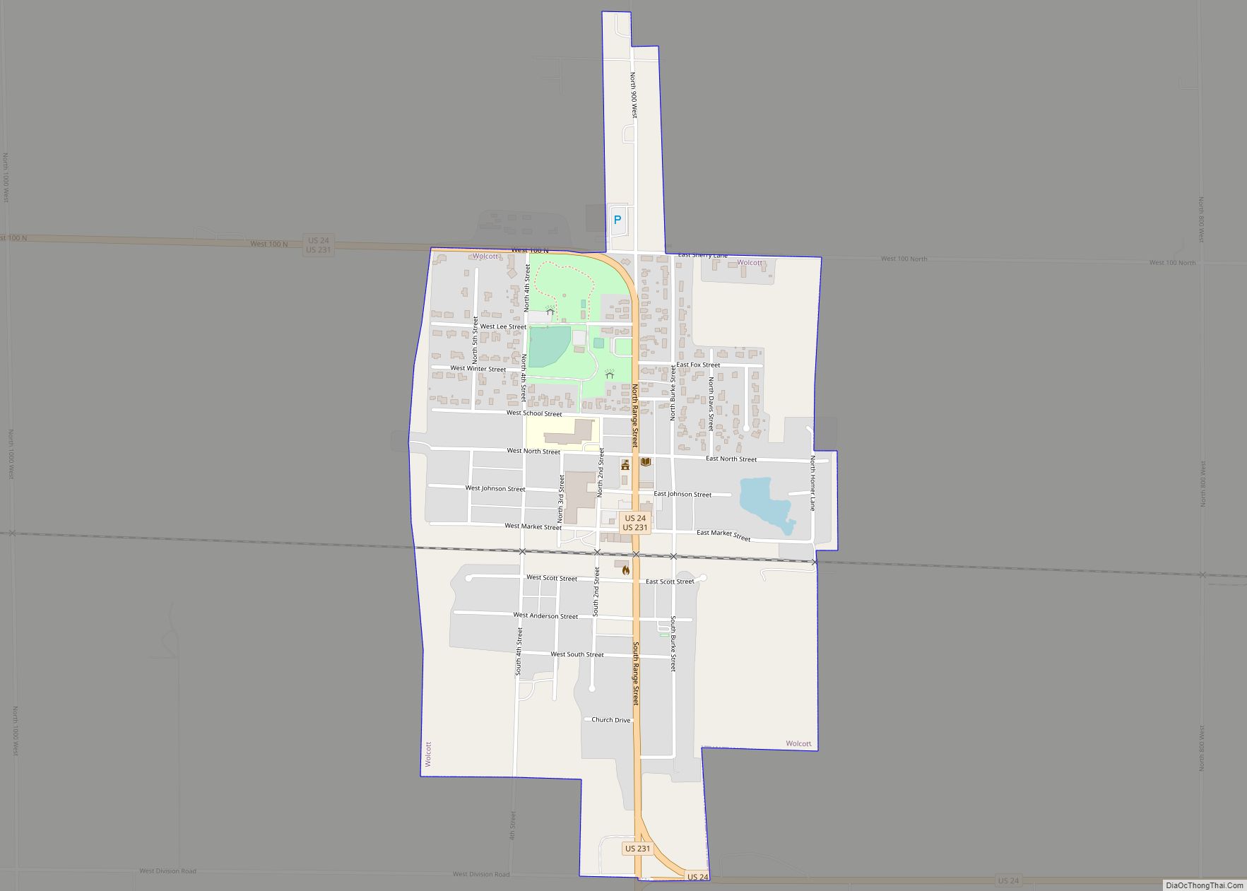
Wolcott (/ˈwʊlkət/ WUUL-kət) is a town in Princeton Township, White County, in the U.S. state of Indiana. The population was 1,001 at the 2010 census. Wolcott town overview: Name: Wolcott town LSAD Code: 43 LSAD Description: town (suffix) State: Indiana County: White County Elevation: 715 ft (218 m) Total Area: 0.59 sq mi (1.54 km²) Land Area: 0.59 sq mi (1.54 km²) Water ... Read more
Map of Wolcott town, Indiana
Map of Winslow town, Indiana
Winslow is a town in Patoka Township, Pike County, in the U.S. state of Indiana. The population was 864 at the 2010 census. It is part of the Jasper Micropolitan Statistical Area. Winslow town overview: Name: Winslow town LSAD Code: 43 LSAD Description: town (suffix) State: Indiana County: Pike County Elevation: 459 ft (140 m) Total Area: ... Read more
Map of Winslow town, Indiana
Map of Worthington town, Indiana
Worthington is a town in Jefferson Township, Greene County, Indiana, United States. The population was 1,463 at the 2010 United States Census. It is part of the Bloomington, Indiana, Metropolitan Statistical Area. Worthington town overview: Name: Worthington town LSAD Code: 43 LSAD Description: town (suffix) State: Indiana County: Greene County Elevation: 515 ft (157 m) Total Area: ... Read more
Map of Worthington town, Indiana
Map of Woodlawn Heights town
Woodlawn Heights is a town in Anderson Township, Madison County, Indiana, United States. It is part of the Indianapolis–Carmel–Anderson metropolitan statistical area. The population was 91 at the 2020 census. Woodlawn Heights town overview: Name: Woodlawn Heights town LSAD Code: 43 LSAD Description: town (suffix) State: Indiana County: Madison County Elevation: 866 ft (264 m) Total Area: ... Read more
Map of Woodlawn Heights town
Map of Woodburn city, Indiana
Woodburn is a city in Maumee Township, Allen County, Indiana, United States. The population was 1,520 at the 2010 census, making it the smallest in state as Cannelton had a population of 1,563 in the 2010 Census. Woodburn city overview: Name: Woodburn city LSAD Code: 25 LSAD Description: city (suffix) State: Indiana County: Allen County ... Read more
Map of Woodburn city, Indiana
Map of Yorktown town, Indiana
Yorktown is a town in Mount Pleasant Township, Delaware County, Indiana, United States. The population was 11,548 at the 2020 census. It is part of the Muncie, IN Metropolitan Statistical Area. Yorktown town overview: Name: Yorktown town LSAD Code: 43 LSAD Description: town (suffix) State: Indiana County: Delaware County Elevation: 902 ft (275 m) Total Area: 32.17 sq mi ... Read more
Map of Yorktown town, Indiana
Map of Yeoman town
Yeoman is a town in Jefferson Township, Carroll County, Indiana, United States. The population was 139 at the 2010 census. It is part of the Lafayette, Indiana Metropolitan Statistical Area. Yeoman town overview: Name: Yeoman town LSAD Code: 43 LSAD Description: town (suffix) State: Indiana County: Carroll County Elevation: 663 ft (202 m) Total Area: 0.13 sq mi (0.33 km²) ... Read more
Map of Yeoman town
Map of Wynnedale town
Wynnedale is a town in Washington Township, Marion County, Indiana, United States. The population was 215 at the 2020 census. It has existed as an “included town” since 1970, when it was incorporated into Indianapolis as part of Unigov. It is part of Indianapolis, but retains a functioning town government under IC 36-3-1-11. Wynnedale town ... Read more
Map of Wynnedale town
Map of Zionsville town
Zionsville is a suburban town located in the extreme southeast area of Boone County, Indiana, United States, northwest of Indianapolis. The population was 14,160 at the 2010 census, 30,693 at the 2020 census. Zionsville promotes itself as a tourist attraction, centered on its village-styled downtown area. This area consists primarily of Main Street, paved entirely ... Read more
Map of Zionsville town
Map of Zanesville town, Indiana
Zanesville is a town in Allen and Wells counties in the U.S. state of Indiana, southwest of Fort Wayne. The population was 600 at the 2010 census. Zanesville town overview: Name: Zanesville town LSAD Code: 43 LSAD Description: town (suffix) State: Indiana County: Allen County, Wells County Elevation: 810 ft (247 m) Total Area: 0.84 sq mi (2.17 km²) Land ... Read more
Map of Zanesville town, Indiana
Map of Abbyville city
Abbyville is a city in Reno County, Kansas, United States. As of the 2020 census, the population of the city was 83. Abbyville city overview: Name: Abbyville city LSAD Code: 25 LSAD Description: city (suffix) State: Kansas County: Reno County Founded: 1880s Incorporated: 1924 Elevation: 1,654 ft (504 m) Total Area: 0.27 sq mi (0.69 km²) Land Area: 0.27 sq mi (0.69 km²) ... Read more
Map of Abbyville city
Map of Admire city
Admire is a city in Lyon County, Kansas, United States. As of the 2020 census, the population of the city was 130. Admire city overview: Name: Admire city LSAD Code: 25 LSAD Description: city (suffix) State: Kansas County: Lyon County Founded: 1886 Incorporated: 1916 Elevation: 1,237 ft (377 m) Total Area: 0.32 sq mi (0.84 km²) Land Area: 0.32 sq mi (0.84 km²) ... Read more
Map of Admire city