Map of Rayne city
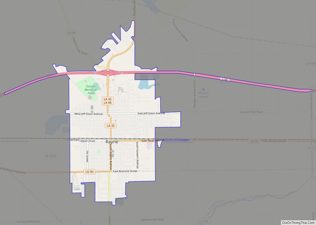
Rayne is a city in the U.S. state of Louisiana, in Acadia Parish. With a population of 7,326 at the 2020 United States census, it is nicknamed the “Frog Capital of the World”, as well as the “Louisiana City of Murals”. Rayne is part of the Crowley micropolitan statistical area, and within the Lafayette metropolitan ... Read more
Map of Rayne city
Map of Reeves village
Reeves is a village in Allen Parish, Louisiana, United States. The population was 232 at the 2010 census. Reeves village overview: Name: Reeves village LSAD Code: 47 LSAD Description: village (suffix) State: Louisiana County: Allen Parish Elevation: 56 ft (17 m) Total Area: 2.42 sq mi (6.27 km²) Land Area: 2.42 sq mi (6.26 km²) Water Area: 0.00 sq mi (0.01 km²) Total Population: 221 Population ... Read more
Map of Reeves village
Map of Reddell CDP
Reddell is a census-designated place and unincorporated community in Evangeline Parish, Louisiana, United States. As of the 2010 census it had a population of 733. It is located approximately 2 miles (3 km) north of Mamou along Louisiana Highway 13. Reddell has a post office (ZIP code 70580), grocery store, and one of the largest rice ... Read more
Map of Reddell CDP
Map of Red Chute CDP
Red Chute is a census-designated place (CDP) in Bossier Parish, Louisiana, United States. The population was 6,261 at the 2010 census. It is part of the Shreveport–Bossier City Metropolitan Statistical Area. Red Chute CDP overview: Name: Red Chute CDP LSAD Code: 57 LSAD Description: CDP (suffix) State: Louisiana County: Bossier Parish Elevation: 213 ft (65 m) Total ... Read more
Map of Red Chute CDP
Map of Richwood town, Louisiana
Richwood is a town in Ouachita Parish, Louisiana, United States. The Town was incorporated December 31, 1974, under the provision of Louisiana Revised Statute 33:52. The Town operates under a form of government consisting of an elected mayor and a board of alder persons, which has five elected members. The Town provides garbage collection, street ... Read more
Map of Richwood town, Louisiana
Map of Richmond village, Louisiana
Richmond is a village in Madison Parish, Louisiana, United States, located on Roundaway Bayou. The population was 577 at the 2010 census. It is part of the Tallulah Micropolitan Statistical Area. Richmond village overview: Name: Richmond village LSAD Code: 47 LSAD Description: village (suffix) State: Louisiana County: Madison Parish Elevation: 75 ft (23 m) Total Area: 1.66 sq mi ... Read more
Map of Richmond village, Louisiana
Map of Reserve CDP, Louisiana
Reserve is an unincorporated community in St. John the Baptist Parish, Louisiana, United States. It is located on the east bank of the Mississippi River. The population was 9,111 at the 2000 census. For statistical purposes, the United States Census Bureau has defined Reserve as a census-designated place (CDP). Reserve CDP overview: Name: Reserve CDP ... Read more
Map of Reserve CDP, Louisiana
Map of River Ridge CDP, Louisiana
River Ridge is an unincorporated community and census-designated place (CDP) in Jefferson Parish, Louisiana, United States. It is a suburb of New Orleans. The population was 13,591 in 2020. River Ridge CDP overview: Name: River Ridge CDP LSAD Code: 57 LSAD Description: CDP (suffix) State: Louisiana County: Jefferson Parish Total Area: 3.55 sq mi (9.19 km²) Land Area: ... Read more
Map of River Ridge CDP, Louisiana
Map of Ringgold town, Louisiana
Ringgold is a town in the U.S. state of Louisiana, in the western half of Bienville Parish. The town of Ringgold is named for United States Army Major Samuel Ringgold. The population of Ringgold was 1,495 at the 2010 census, and 1,370 at the U.S. Census Bureau’s 2019 estimates, down from 1,601 in 2018. The ... Read more
Map of Ringgold town, Louisiana
Map of Ridgecrest town, Louisiana
Ridgecrest is a small town in Concordia Parish, Louisiana, United States. The population was 694 at the 2010 census. Ridgecrest town overview: Name: Ridgecrest town LSAD Code: 43 LSAD Description: town (suffix) State: Louisiana County: Concordia Parish Elevation: 52 ft (16 m) Total Area: 0.43 sq mi (1.11 km²) Land Area: 0.43 sq mi (1.11 km²) Water Area: 0.00 sq mi (0.00 km²) Total Population: 583 ... Read more
Map of Ridgecrest town, Louisiana
Map of Rock Hill CDP, Louisiana
Rock Hill is an unincorporated community and census-designated place (CDP) in Grant Parish, Louisiana, United States. As of the 2010 census it had a population of 274. Rock Hill is located in southwestern Grant Parish along U.S. Route 71, which leads northwest 10 miles (16 km) to Colfax, the parish seat, and southeast 17 miles (27 km) ... Read more
Map of Rock Hill CDP, Louisiana
Map of Robeline village
Robeline is a village in western Natchitoches Parish, Louisiana, United States. The population was 183 at the 2000 census. It is part of the Natchitoches Micropolitan Statistical Area. Robeline village overview: Name: Robeline village LSAD Code: 47 LSAD Description: village (suffix) State: Louisiana County: Natchitoches Parish Total Area: 1.19 sq mi (3.08 km²) Land Area: 1.19 sq mi (3.08 km²) Water ... Read more
Map of Robeline village