Map of Chevy Chase View town
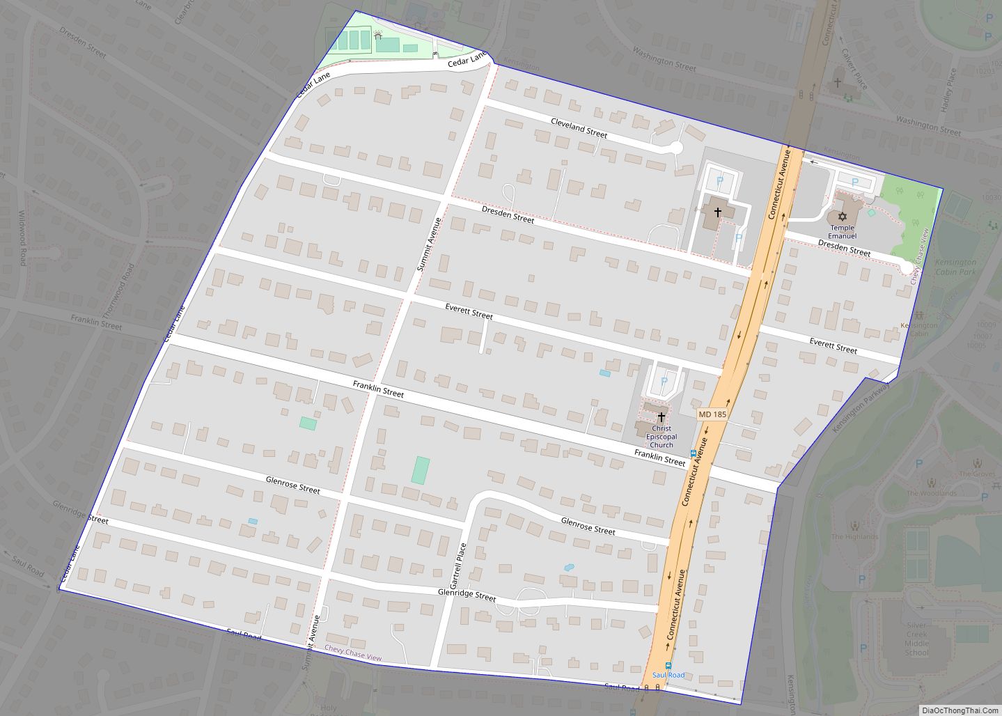
Chevy Chase View is a town located in Montgomery County, Maryland, United States. Established as a Special Tax District in 1924, the town was formally incorporated on October 28, 1993. The population was 920 at the 2010 census. Chevy Chase View town overview: Name: Chevy Chase View town LSAD Code: 43 LSAD Description: town (suffix) ... Read more
Map of Chevy Chase View town
Map of Choptank CDP
Choptank is an unincorporated town and census-designated place on the Eastern Shore of Maryland, in Caroline County, Maryland, United States. As of the 2010 census it had a population of 129. The town was founded in the 17th century. It is located on the tidal Choptank River, which flows into Chesapeake Bay. Tradition has it ... Read more
Map of Choptank CDP
Map of Chillum CDP
Chillum is an unincorporated area and census-designated place in Prince George’s County, Maryland, United States, bordering Washington, D.C. and Montgomery County. In addition to being its own unincorporated neighborhood, Chillum is also a census-designated place covering a larger area than the Chillum neighborhood. As of the 2010 census, the Chillum CDP included Chillum, as well ... Read more
Map of Chillum CDP
Map of Chewsville CDP
Chewsville is a census-designated place (CDP) in Washington County, Maryland, United States. The population was 293 at the 2000 census. Chewsville CDP overview: Name: Chewsville CDP LSAD Code: 57 LSAD Description: CDP (suffix) State: Maryland County: Washington County Elevation: 636 ft (194 m) Total Area: 0.83 sq mi (2.16 km²) Land Area: 0.83 sq mi (2.16 km²) Water Area: 0.00 sq mi (0.00 km²) Total Population: ... Read more
Map of Chewsville CDP
Map of Clarksburg CDP, Maryland
Clarksburg is a census-designated place and an unincorporated area in northern Montgomery County, Maryland, United States. It is located at the northern end of the Interstate 270 technology corridor, approximately four miles north of Germantown. As of the 2020 census, Clarksburg had a population of 29,051. Clarksburg CDP overview: Name: Clarksburg CDP LSAD Code: 57 ... Read more
Map of Clarksburg CDP, Maryland
Map of Church Hill town, Maryland
Church Hill is a town in Queen Anne’s County, Maryland, United States. The population was 745 at the 2010 census. Church Hill town overview: Name: Church Hill town LSAD Code: 43 LSAD Description: town (suffix) State: Maryland County: Queen Anne’s County Incorporated: 1876 Elevation: 39 ft (12 m) Total Area: 0.72 sq mi (1.86 km²) Land Area: 0.72 sq mi (1.86 km²) Water ... Read more
Map of Church Hill town, Maryland
Map of Church Creek town
Church Creek is a town in Dorchester County, Maryland, United States, part of the state’s Eastern Shore. The population was 125 at the 2010 census. Church Creek is located approximately six miles south of Cambridge. Old Trinity Church is located here. An Anglican (now Episcopal) brick church built in 1675, it is the oldest church ... Read more
Map of Church Creek town
Map of Clear Spring town
Clear Spring is a town in Washington County, Maryland, United States. The population was 358 at the 2010 census. Clear Spring town overview: Name: Clear Spring town LSAD Code: 43 LSAD Description: town (suffix) State: Maryland County: Washington County Incorporated: 1836 Elevation: 571 ft (174 m) Total Area: 0.12 sq mi (0.30 km²) Land Area: 0.12 sq mi (0.30 km²) Water Area: 0.00 sq mi ... Read more
Map of Clear Spring town
Map of Clarysville CDP
Clarysville is an unincorporated community and census-designated place (CDP) in Allegany County, Maryland, United States. As of the 2010 census it had a population of 73. It is located along U.S. Route 40 Alternate at its intersection with Maryland Route 55. Frostburg is 2 miles (3 km) to the west, and Cumberland is 7 miles (11 km) ... Read more
Map of Clarysville CDP
Map of Clinton CDP, Maryland
Clinton is an unincorporated census-designated place (CDP) in Prince George’s County, Maryland, United States. Clinton was formerly known as Surrattsville until after the time of the Civil War. The population of Clinton was 38,760 at the 2020 census. Clinton is historically known for its role in the American Civil War concerning the Abraham Lincoln assassination. ... Read more
Map of Clinton CDP, Maryland
Map of Cockeysville CDP
Cockeysville is a census-designated place (CDP) in Baltimore County, Maryland, United States. The population was 20,776 at the 2010 census. Cockeysville CDP overview: Name: Cockeysville CDP LSAD Code: 57 LSAD Description: CDP (suffix) State: Maryland County: Baltimore County Elevation: 308 ft (94 m) Total Area: 12.38 sq mi (32.06 km²) Land Area: 11.97 sq mi (31.01 km²) Water Area: 0.40 sq mi (1.04 km²) Total Population: ... Read more
Map of Cockeysville CDP
Map of Cobb Island CDP
Cobb Island is a small island located at the confluence of the Potomac and Wicomico rivers in southern Charles County, Maryland, United States. It is located approximately 45 miles (72 km) south of Washington, and is considered to be within the Washington, D.C. MSA. Cobb Island is separated from the mainland by Neale Sound and connected ... Read more
Map of Cobb Island CDP