Map of Chance CDP
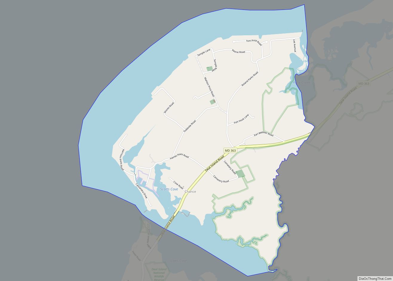
Chance is a census-designated place (CDP) in Somerset County, Maryland, United States. The population was 377 at the 2000 census. It is included in the Salisbury, Maryland-Delaware Metropolitan Statistical Area. Chance CDP overview: Name: Chance CDP LSAD Code: 57 LSAD Description: CDP (suffix) State: Maryland County: Somerset County Elevation: 3 ft (1 m) Total Area: 2.58 sq mi (6.69 km²) ... Read more
Map of Chance CDP
Map of Charlton CDP
Charlton is an unincorporated community and census-designated place in Washington County, Maryland, United States. Its population was 171 as of the 2010 census. Charlton CDP overview: Name: Charlton CDP LSAD Code: 57 LSAD Description: CDP (suffix) State: Maryland County: Washington County Total Area: 0.16 sq mi (0.42 km²) Land Area: 0.16 sq mi (0.42 km²) Water Area: 0.00 sq mi (0.00 km²) Total Population: ... Read more
Map of Charlton CDP
Map of Chesapeake City town
Chesapeake City is a town in Cecil County, Maryland, United States. The population was 736 at the 2020 census. The town was originally named by Bohemian colonist Augustine Herman the Village of Bohemia — or Bohemia Manor — but the name was changed in 1839 after the Chesapeake and Delaware Canal (C&D Canal) was built ... Read more
Map of Chesapeake City town
Map of Chesapeake Beach town
Chesapeake Beach is a town in Calvert County, Maryland, United States. Its major attractions include the Chesapeake Beach Railway Station, the Chesapeake Beach Rail Trail, a water park, marinas, piers, and charter boat fishing. The town’s population was recorded as 5,753 in the 2010 census. Chesapeake Beach town overview: Name: Chesapeake Beach town LSAD Code: ... Read more
Map of Chesapeake Beach town
Map of Chestertown town, Maryland
Chestertown is a town in Kent County, Maryland. The population was 5,252 as of the 2010 census. It is the county seat of Kent County. Chestertown town overview: Name: Chestertown town LSAD Code: 43 LSAD Description: town (suffix) State: Maryland County: Kent County Incorporated: 1805 Elevation: 20 ft (6 m) Total Area: 3.29 sq mi (8.51 km²) Land Area: 2.92 sq mi ... Read more
Map of Chestertown town, Maryland
Map of Chester CDP, Maryland
Chester is a census-designated place on Kent Island in Queen Anne’s County, Maryland, United States. The population was 3,723 at the 2000 census. Chester CDP overview: Name: Chester CDP LSAD Code: 57 LSAD Description: CDP (suffix) State: Maryland County: Queen Anne’s County Elevation: 7 ft (2 m) Total Area: 6.98 sq mi (18.09 km²) Land Area: 5.24 sq mi (13.56 km²) Water Area: ... Read more
Map of Chester CDP, Maryland
Map of Chesapeake Ranch Estates CDP
The Chesapeake Ranch Estates (CRE), also known locally as the Ranch Club, is located in Lusby, Maryland, United States, in southern Calvert County. CRE was founded in 1958 and is governed by a homeowners’ association, which is officially called the “Property Owner’s Association of the Chesapeake Ranch Estates” (POACRE). Today, CRE is composed of over ... Read more
Map of Chesapeake Ranch Estates CDP
Map of Chevy Chase Section Three village
Chevy Chase Section Three is a village in Montgomery County, Maryland. It was organized as a Special Tax District in 1916 and incorporated as a village in 1982. The population was 760 at the 2010 census. It is part of a larger community, colloquially referred to as Chevy Chase, that includes several adjoining settlements in ... Read more
Map of Chevy Chase Section Three village
Map of Chevy Chase Section Five village
Chevy Chase Section Five is an incorporated village in Montgomery County, Maryland, United States. The population was 672 at the 2020 census. It is part of a larger community, colloquially referred to as Chevy Chase, that includes several adjoining settlements in Montgomery County and one neighborhood of Washington, D.C. Chevy Chase Section Five village overview: ... Read more
Map of Chevy Chase Section Five village
Map of Cheverly town
Cheverly is a town in Prince George’s County, Maryland, United States, located very close to Washington, D.C., though not bordering it directly. The town was founded in 1918 and incorporated in 1931. Per the 2020 census, the population was 6,170. Cheverly borders the communities of Tuxedo, Chapel Oaks, Landover, Landover Hills, Villa Heights, and Bladensburg. ... Read more
Map of Cheverly town
Map of Chevy Chase CDP
Chevy Chase (/ˈtʃɛviː tʃeɪs/) is a census-designated place (CDP) in Montgomery County, Maryland, United States. The population was 10,176 at the 2020 census. Chevy Chase CDP overview: Name: Chevy Chase CDP LSAD Code: 57 LSAD Description: CDP (suffix) State: Maryland County: Montgomery County Elevation: 361 ft (110 m) Total Area: 2.42 sq mi (6.26 km²) Land Area: 2.41 sq mi (6.25 km²) Water ... Read more
Map of Chevy Chase CDP
Map of Chevy Chase Village town
Chevy Chase Village, Maryland is an incorporated municipality in Montgomery County, Maryland, United States, bordering Washington, D.C. It is made up of sections 1, 1a, and 2 of Chevy Chase, as originally designated by The Chevy Chase Land Company. The population was 1,953 as of the 2010 census. The town is the wealthiest in Maryland, ... Read more
Map of Chevy Chase Village town