Map of Fairlee CDP, Maryland
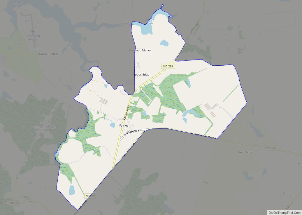
Fairlee is an unincorporated community and census-designated place in Kent County, Maryland, United States. Its population was 490 as of the 2010 census. The Battle of Caulk’s Field during the War of 1812 took place near Fairlee on August 31, 1814; it ended in victory for the local militia, and the British commander was killed ... Read more
Map of Fairlee CDP, Maryland
Map of Fairwood CDP, Maryland
Fairwood is an unincorporated area and census-designated place (CDP) in Prince George’s County, Maryland, United States. The population was 7,983 at the 2020 census. Fairwood CDP overview: Name: Fairwood CDP LSAD Code: 57 LSAD Description: CDP (suffix) State: Maryland County: Prince George’s County Elevation: 36 ft (11 m) Total Area: 3.42 sq mi (8.85 km²) Land Area: 3.41 sq mi (8.84 km²) Water ... Read more
Map of Fairwood CDP, Maryland
Map of Fairview CDP, Maryland
Fairview is an unincorporated community and census-designated place in Washington County, Maryland, United States. Its population was 76 as of the 2010 census. Fairview CDP overview: Name: Fairview CDP LSAD Code: 57 LSAD Description: CDP (suffix) State: Maryland County: Washington County Elevation: 495 ft (151 m) Total Area: 0.21 sq mi (0.54 km²) Land Area: 0.21 sq mi (0.54 km²) Water Area: 0.00 sq mi ... Read more
Map of Fairview CDP, Maryland
Map of Fairplay CDP, Maryland
Fairplay is an unincorporated community and census-designated place (CDP) in Washington County, Maryland, United States. Its population was 580 as of the 2010 census. It is sometimes recognized, along with neighboring Tilghmanton, as Fairplay-Tilghmanton; the two communities share a post office as well as a fire company. Fairplay is located between Hagerstown and Sharpsburg, along ... Read more
Map of Fairplay CDP, Maryland
Map of Ferndale CDP, Maryland
Ferndale is a census-designated place (CDP) in Anne Arundel County, Maryland, United States. At the 2010 census, the population was 16,746. Ferndale CDP overview: Name: Ferndale CDP LSAD Code: 57 LSAD Description: CDP (suffix) State: Maryland County: Anne Arundel County Elevation: 79 ft (24 m) Total Area: 3.96 sq mi (10.25 km²) Land Area: 3.96 sq mi (10.25 km²) Water Area: 0.00 sq mi (0.00 km²) ... Read more
Map of Ferndale CDP, Maryland
Map of Federalsburg town
Federalsburg is a town in Caroline County, Maryland, United States. The population was 2,739 at the 2010 United States Census. It has one high school, Colonel Richardson High School. Federalsburg town overview: Name: Federalsburg town LSAD Code: 43 LSAD Description: town (suffix) State: Maryland County: Caroline County Incorporated: 1823 Elevation: 3 ft (1 m) Total Area: 1.99 sq mi ... Read more
Map of Federalsburg town
Map of Fallston CDP, Maryland
Fallston is a census-designated place (CDP) in Harford County, Maryland, United States. The population was 8,958 at the 2010 census, up from 8,427 in 2000. Fallston is a semi-rural community consisting mostly of farms and suburban-like developments. Fallston CDP overview: Name: Fallston CDP LSAD Code: 57 LSAD Description: CDP (suffix) State: Maryland County: Harford County ... Read more
Map of Fallston CDP, Maryland
Map of Flintstone CDP
Flintstone is an unincorporated community and census-designated place (CDP) in Allegany County, Maryland, United States. As of the 2010 census it had a population of 177. It is part of the Cumberland, MD-WV Metropolitan Statistical Area. Flintstone lies between the southern foot of Tussey Mountain and a water gap in Warrior Mountain formed by Flintstone ... Read more
Map of Flintstone CDP
Map of Fishing Creek CDP
Fishing Creek is an unincorporated community and census-designated place (CDP) in Dorchester County, Maryland, United States, on Upper Hoopers Island. As of the 2010 census, the population of Fishing Creek was 163. It is in area code 410, and ZIP code 21634. Fishing Creek CDP overview: Name: Fishing Creek CDP LSAD Code: 57 LSAD Description: ... Read more
Map of Fishing Creek CDP
Map of Finzel CDP
Finzel is a census-designated place (CDP) in Garrett County, Maryland, United States. Finzel is located on Maryland Route 546 near the Pennsylvania border. As of the 2010 census, its population was 547. Finzel CDP overview: Name: Finzel CDP LSAD Code: 57 LSAD Description: CDP (suffix) State: Maryland County: Garrett County Elevation: 2,543 ft (775 m) Total Area: ... Read more
Map of Finzel CDP
Map of Forestville CDP, Maryland
Forestville is an unincorporated area and census-designated place (CDP) in Prince George’s County, Maryland, United States. Per the 2020 census, the population was 12,831. The community is a mixture of garden apartments, single-family homes, and shopping centers built mostly from the 1930s through 1970s, adjacent to the communities of District Heights, Suitland, Morningside, Westphalia and ... Read more
Map of Forestville CDP, Maryland
Map of Forest Heights town
Forest Heights is a town in Prince George’s County, Maryland, United States, and is part of the larger postal designation of Oxon Hill. The town straddles both sides of dual-lane Maryland Route 210 and includes two elementary schools. Per the 2020 census, the population was 2,658. Forest Heights town overview: Name: Forest Heights town LSAD ... Read more
Map of Forest Heights town