Map of Hampstead town, Maryland
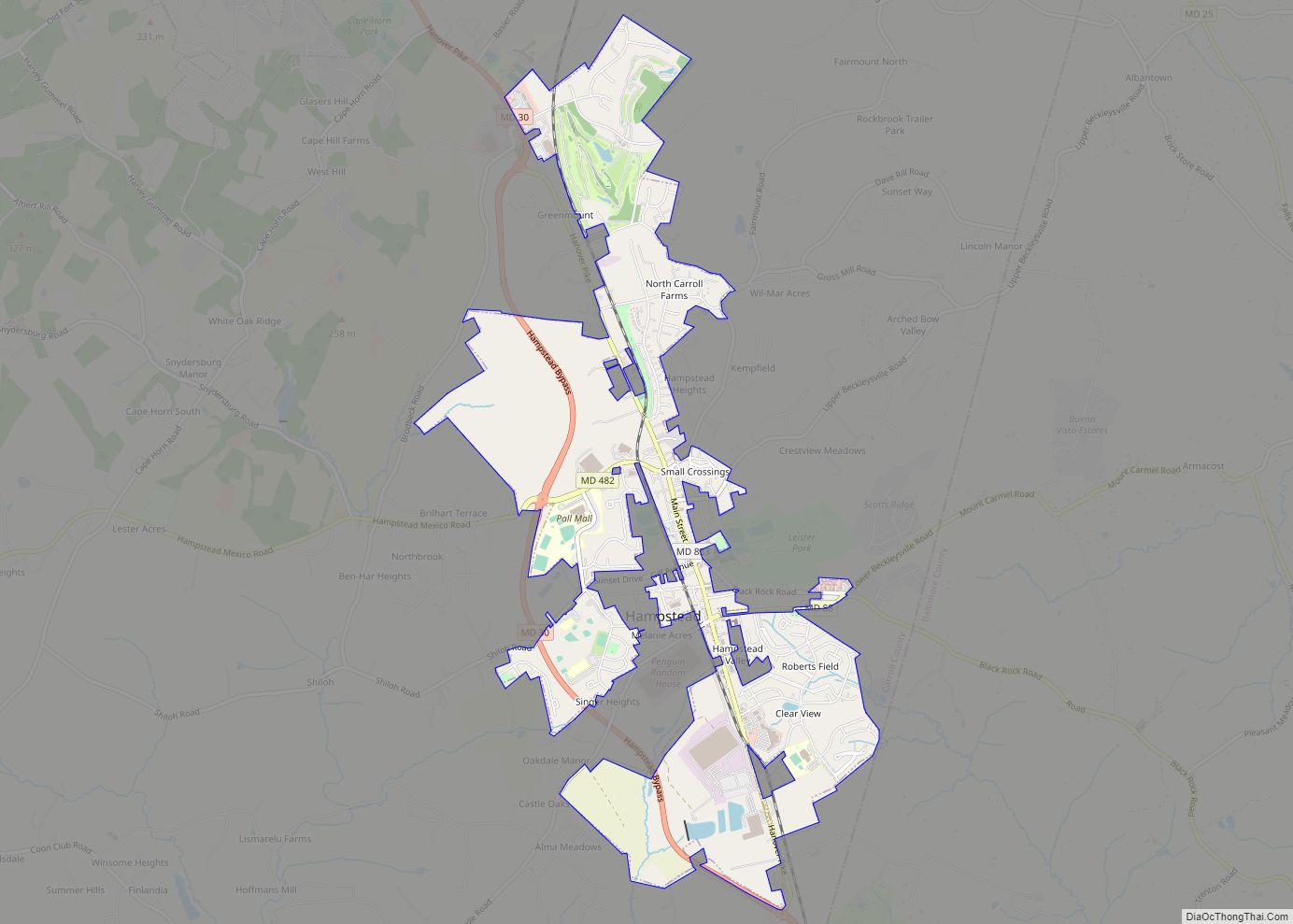
Hampstead is a town in Carroll County in the U.S. state of Maryland. The population was 6,323 at the 2010 census. Hampstead town overview: Name: Hampstead town LSAD Code: 43 LSAD Description: town (suffix) State: Maryland County: Carroll County Incorporated: 1888 Elevation: 928 ft (283 m) Total Area: 3.33 sq mi (8.62 km²) Land Area: 3.30 sq mi (8.55 km²) Water Area: 0.03 sq mi ... Read more
Map of Hampstead town, Maryland
Map of Henderson town, Maryland
Henderson is a town in Caroline County, Maryland, United States. The population was 146 at the 2010 United States Census. It was named for a stockholder of the Delaware and Chesapeake Railroad. Athol was listed on the National Register of Historic Places in 1989. Henderson town overview: Name: Henderson town LSAD Code: 43 LSAD Description: ... Read more
Map of Henderson town, Maryland
Map of Hebron town, Maryland
Hebron is a town in Wicomico County, Maryland, United States. The population was 1,084 at the 2010 census. It is included in the Salisbury, Maryland-Delaware Metropolitan Statistical Area. It is the hometown of pro-wrestler Mark Hildreth and politician Scott Taylor. Hebron town overview: Name: Hebron town LSAD Code: 43 LSAD Description: town (suffix) State: Maryland ... Read more
Map of Hebron town, Maryland
Map of Havre de Grace city
Havre de Grace (/hævər dɪˈɡreɪs/), abbreviated HdG, is a city in Harford County, Maryland. It is situated at the mouth of the Susquehanna River and the head of Chesapeake Bay. It is named after the port city of Le Havre, France, which in full was once Le Havre de Grâce (French, “Harbor of Grace”). The ... Read more
Map of Havre de Grace city
Map of Highland Beach town, Maryland
Highland Beach is a town in Anne Arundel County, Maryland, United States. Per the 2020 census, the population was 118. The town was founded late in the 19th century by affluent African Americans from Washington, D.C. and Baltimore, looking for a summer retreat on the Chesapeake Bay. The town’s incorporated status gave it a unique ... Read more
Map of Highland Beach town, Maryland
Map of Highfield-Cascade CDP
Highfield-Cascade is a census-designated place (CDP) in Washington County, Maryland, United States. The CDP encompasses two closely-spaced unincorporated communities, Highfield and Cascade, which are usually referred to separately. The population of the combined CDP was 1,141 at the 2000 census. Highfield-Cascade CDP overview: Name: Highfield-Cascade CDP LSAD Code: 57 LSAD Description: CDP (suffix) State: Maryland ... Read more
Map of Highfield-Cascade CDP
Map of Herald Harbor CDP
Herald Harbor is a census-designated place and an unincorporated community in Anne Arundel County, Maryland, United States. As of the 2010 census, the population was 2,603. It is a quiet residential area with a scenic view of the Severn River and is near the community of Crownsville and Interstate 97. Herald Harbor is known for ... Read more
Map of Herald Harbor CDP
Map of Hillcrest Heights CDP, Maryland
Hillcrest Heights is an unincorporated area and census-designated place (CDP) in Prince George’s County, Maryland, United States. The population was 15,793 at the 2020 census. For mailing address purposes, it is part of the smaller community of Temple Hills and is also near Suitland. Hillcrest Heights CDP overview: Name: Hillcrest Heights CDP LSAD Code: 57 ... Read more
Map of Hillcrest Heights CDP, Maryland
Map of Hillandale CDP
Hillandale is an unincorporated area and census-designated place located in Montgomery and Prince George’s counties, Maryland, United States. As of the 2020 census, it had a population of 5,774. Hillandale is contained between the Prince George’s / Montgomery County line to the east, the Anacostia River to the west, McCeney Avenue to the north, and ... Read more
Map of Hillandale CDP
Map of Highland CDP, Maryland
Highland is an unincorporated community and census-designated place in Howard County, Maryland, United States. As of the 2020 census it had a population of 1,133. It uses the 20777 zip code. Highland CDP overview: Name: Highland CDP LSAD Code: 57 LSAD Description: CDP (suffix) State: Maryland County: Howard County Elevation: 520 ft (160 m) Total Area: 2.42 sq mi ... Read more
Map of Highland CDP, Maryland
Map of Hillsboro town, Maryland
Hillsboro is a town in Caroline County, Maryland, United States. The population was 161 at the 2010 United States Census. Daffin House and St. Paul’s Episcopal Church were listed on the National Register of Historic Places in 1975. Hillsboro town overview: Name: Hillsboro town LSAD Code: 43 LSAD Description: town (suffix) State: Maryland County: Caroline ... Read more
Map of Hillsboro town, Maryland
Map of Huntingtown CDP
Huntingtown, established 1683, is a census-designated place (CDP) in Calvert County, Maryland, United States. The population was 3,311 at the 2010 census, up from 2,436 in 2000. Many large estate homes have recently been built in small developments off routes 2/4. It has a public high school called Huntingtown High. The Calverton School is located ... Read more
Map of Huntingtown CDP