Map of Melwood CDP
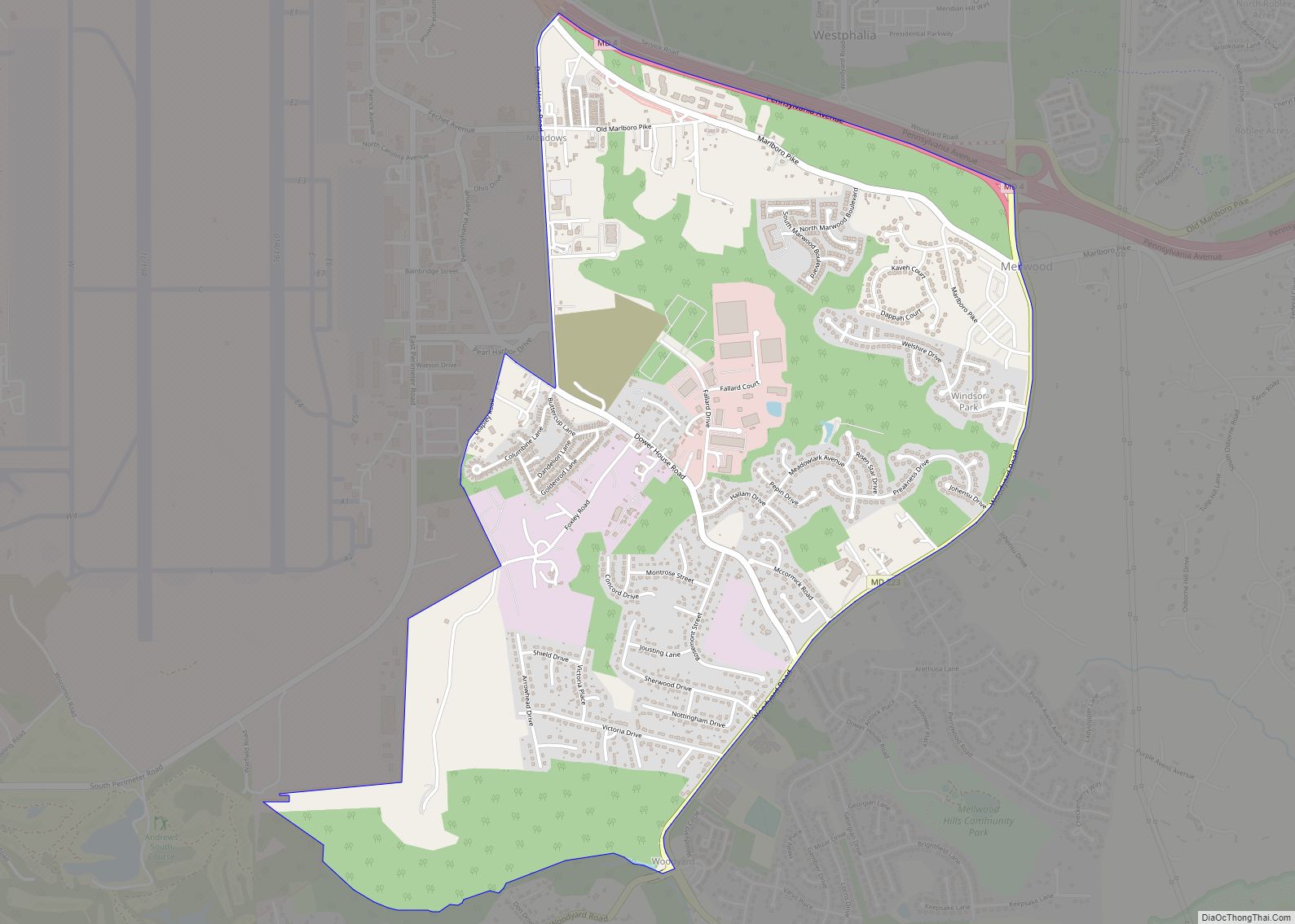
Melwood is an unincorporated community and census-designated place (CDP) in Prince George’s County, Maryland, United States. It was newly delineated for the 2010 census, at which time its population was 3,051. Per the 2020 census, the population was 3,977. Melwood CDP overview: Name: Melwood CDP LSAD Code: 57 LSAD Description: CDP (suffix) State: Maryland County: ... Read more
Map of Melwood CDP
Map of Midland town, Maryland
Midland is a town in Allegany County, Maryland, United States, along the Georges Creek Valley. It is part of the Cumberland, MD-WV Metropolitan Statistical Area. The population was 446 at the 2010 census. Midland was founded in 1850 as a coal-mining community, though today only some strip mining remains. Midland town overview: Name: Midland town ... Read more
Map of Midland town, Maryland
Map of Middletown town, Maryland
Middletown is a town in Frederick County, Maryland, United States. The population was 4,136 as of the 2010 census. Located in the Middletown Valley that stretches between the Catoctin Mountains on the east and South Mountain on the west, the town reportedly gained its name from its location midway between those ranges. Middletown town overview: ... Read more
Map of Middletown town, Maryland
Map of Middleburg CDP, Maryland
Middleburg is an unincorporated community and census-designated place in Washington County, Maryland, United States. Its population was 70 as of the 2010 census. Middleburg CDP overview: Name: Middleburg CDP LSAD Code: 57 LSAD Description: CDP (suffix) State: Maryland County: Washington County Total Area: 0.10 sq mi (0.25 km²) Land Area: 0.10 sq mi (0.25 km²) Water Area: 0.00 sq mi (0.00 km²) Total Population: ... Read more
Map of Middleburg CDP, Maryland
Map of Millington town, Maryland
Millington is a town in Kent and Queen Anne’s counties in the U.S. state of Maryland. The population was 642 at the 2010 census. Millington is the head of navigation for the Chester River. Millington town overview: Name: Millington town LSAD Code: 43 LSAD Description: town (suffix) State: Maryland County: Kent County, Queen Anne’s County ... Read more
Map of Millington town, Maryland
Map of Milford Mill CDP
Milford Mill is an unincorporated community and census-designated place in Baltimore County, Maryland, United States. Per the 2020 census, the population was 30,622. According to the United States Census Bureau, the CDP has a total area of 7.0 square miles (18 km), all of it land. The true name of the area is “Milford”, but the ... Read more
Map of Milford Mill CDP
Map of Midlothian CDP, Maryland
Midlothian is an unincorporated community and census-designated place (CDP) in Allegany County, Maryland, United States; at one time it was called Midlothian Junction. As of the 2010 census it had a population of 320. Its ZIP code is 21543. Midlothian is located 2 miles (3 km) southwest of Frostburg and is adjacent to Exit 33 of ... Read more
Map of Midlothian CDP, Maryland
Map of Montgomery Village CDP
Montgomery Village is a census-designated place (CDP) in Montgomery County, Maryland, United States, and a northern suburb of Washington, D.C. It is a large, planned suburban community, developed in the late 1960s and 1970s just outside Gaithersburg‘s city limits. Montgomery Village’s population was 34,893 at the time of the 2020 U.S. Census, and it is ... Read more
Map of Montgomery Village CDP
Map of Monrovia CDP, Maryland
Monrovia is an unincorporated community and census-designated place (CDP) in Frederick County, in the U.S. state of Maryland. As of the 2020 census it had a population of 2,702. The ZIP code for the area is 21770. Monrovia CDP overview: Name: Monrovia CDP LSAD Code: 57 LSAD Description: CDP (suffix) State: Maryland County: Frederick County ... Read more
Map of Monrovia CDP, Maryland
Map of Mitchellville CDP, Maryland
Mitchellville is an upper-class majority African-American unincorporated area and census-designated place (CDP) in Prince George’s County, Maryland, United States. Per the 2020 census, the population was 11,136. Mitchellville CDP overview: Name: Mitchellville CDP LSAD Code: 57 LSAD Description: CDP (suffix) State: Maryland County: Prince George’s County Elevation: 105 ft (32 m) Total Area: 4.96 sq mi (12.84 km²) Land Area: ... Read more
Map of Mitchellville CDP, Maryland
Map of Mount Aetna CDP, Maryland
Mount Aetna is a census-designated place (CDP) in Washington County, Maryland, United States. The population was 838 at the 2000 census. Mount Aetna CDP overview: Name: Mount Aetna CDP LSAD Code: 57 LSAD Description: CDP (suffix) State: Maryland County: Washington County Elevation: 535 ft (163 m) Total Area: 1.41 sq mi (3.66 km²) Land Area: 1.41 sq mi (3.66 km²) Water Area: 0.00 sq mi ... Read more
Map of Mount Aetna CDP, Maryland
Map of Moscow CDP, Maryland
Moscow is an unincorporated community and census-designated place (CDP) in Allegany County, Maryland, United States. As of the 2010 census it had a population of 240. Moscow is located in the Georges Creek Valley of western Allegany County, 11 miles (18 km) southwest of Frostburg and 6 miles (10 km) northeast of Westernport. Moscow CDP overview: Name: ... Read more
Map of Moscow CDP, Maryland