Mount Airy is a town in Carroll and Frederick counties in the U.S. state of Maryland. It is part of both the Washington Metropolitan Area and Baltimore Metropolitan Area. As of the 2010 census the population was 9,288.
Outside the town limits, the surrounding countryside is colloquially referred to as Mount Airy or the “Four-County Area” by locals. The “Four-County Area” derives its name from the fact that the “Mount Airy” mailing area encompasses portions of Frederick, Carroll, Montgomery, and Howard counties.
| Name: | Mount Airy town |
|---|---|
| LSAD Code: | 43 |
| LSAD Description: | town (suffix) |
| State: | Maryland |
| County: | Carroll County, Frederick County |
| Elevation: | 781 ft (238 m) |
| Total Area: | 4.13 sq mi (10.71 km²) |
| Land Area: | 4.12 sq mi (10.68 km²) |
| Water Area: | 0.01 sq mi (0.03 km²) |
| Total Population: | 9,654 |
| Population Density: | 2,341.50/sq mi (904.07/km²) |
| ZIP code: | 21771 |
| Area code: | 301, 240 |
| FIPS code: | 2453875 |
| GNISfeature ID: | 0585976 |
| Website: | www.mountairymd.org |
Online Interactive Map
Click on ![]() to view map in "full screen" mode.
to view map in "full screen" mode.
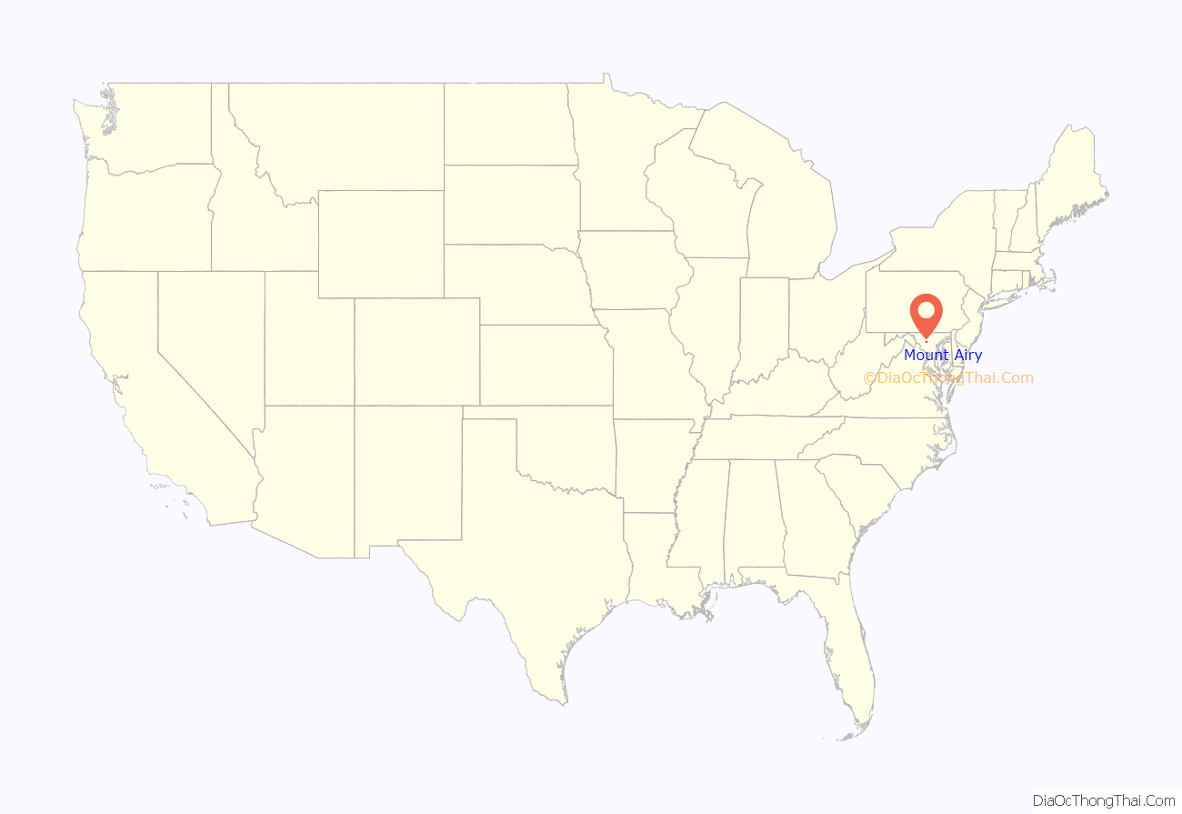
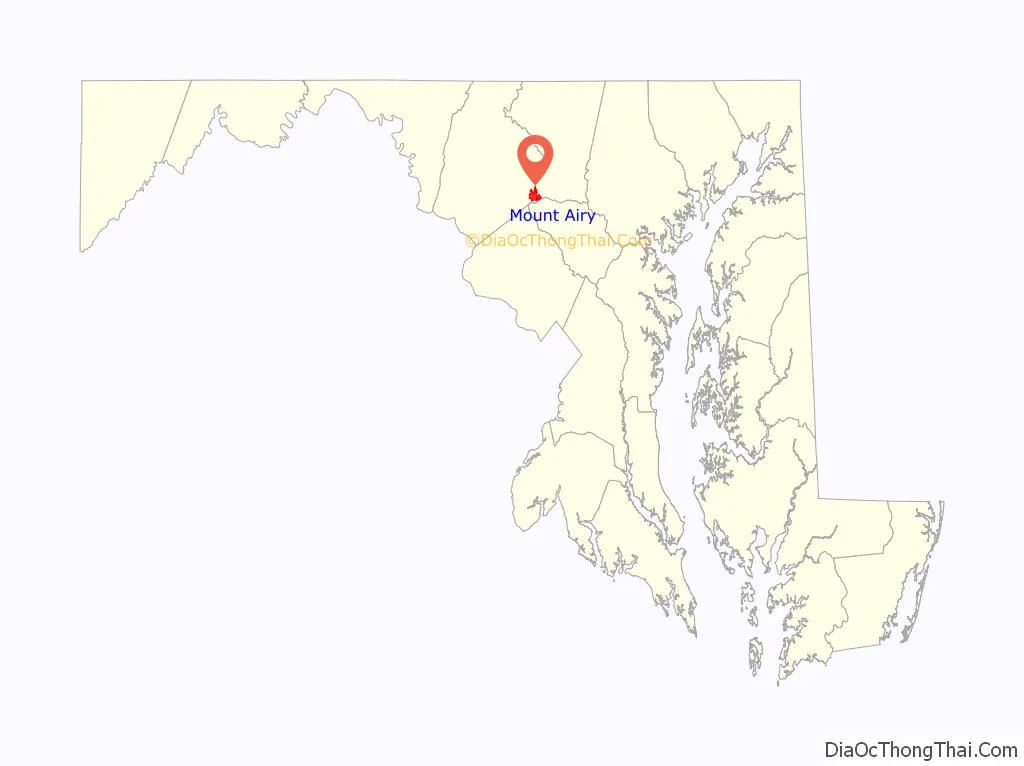
Mount Airy location map. Where is Mount Airy town?
History
The community was first settled in 1830 and continued to develop throughout the decade, beginning with the construction of house settlements along Parr’s Ridge. A man named Henry Bussard built the first of these houses. This town was known for its train station on the Baltimore and Ohio Railroad (B&O) at Parr’s Ridge. The railroad ran from Baltimore to Frederick, cities to the east and west, respectively, of Mt. Airy. Following 1830, the town received its official name after the suggestion of “Mount Airy” from an Irish B&O worker who complained about his freezing ears on a windy work day. Over the years, milling, canning and sewing industries initially helped support Mt. Airy’s economy.
The town’s proximity to the National Road contributed to its growth. The National Road ran west from Baltimore to Illinois. By the 1890s, the town’s growth had increased significantly and three new churches were built (one Episcopal and two Methodist), along with a very important bridge, still standing and known by residents as the Twin Arch, that helped with railroad transportation. Three great fires (1903, 1914, and 1925) caused setbacks in growth, but the town rebuilt every time.
When Carroll County defined its permanent boundaries in 1837, Mount Airy was divided between two counties, Carroll and Frederick; the town has remained in two counties since that time. About one mile south of the town is the junction of Carroll, Frederick, Howard and Montgomery counties at the source of the South Branch of the Patapsco River.
The town was originally settled in the early 1830s by a core group of six families. Dorsey, Davis and Bussard were the most prominent names in that first settlement, which was followed closely by the construction of the B & O railroad line in 1831. Because Mount Airy sits at an elevation of 830 feet (250 m), a series of four inclined planes were constructed in order for the trains to climb the steep hills. Locomotives and cars were lifted with the assistance of horses and steam winches. Passengers had to disembark during this process. Plane #4, located west of the town at the intersection of Woodville Road and MD Route 144, is still a recognized location today. In 1839 the planes were abandoned, and the new line was constructed north of where Mount Airy is today. This was a result of more powerful locomotives that had been constructed and heavier loads were being hauled. In 1901, a railroad tunnel was constructed on the south side of town and the existing line into town became a spur line into the center of Mount Airy. The town named the first resident, Henry Bussard, the station agent for the new train station. Mr. Bussard was the first major landowner in Mount Airy.
By 1846, the town was sparsely settled with several houses, a store, barber shop and shoemaker shop. Pine Grove Chapel, circa 1846, now a historic monument, was constructed to fill the need for a community church. From the time it was constructed, the chapel basement functioned as a private school. The chapel remained open during the early part of the Civil War despite soldier encampments in proximity. The school and church were closed later because of distracting soldier activity around the vicinity of the school. After the war ended, the church reopened in 1867 after undergoing a renovation.
In 1893, the Carroll County Board of Education funded the construction of a three-room schoolhouse which was completed in September 1894. The building, approximately 1,700 square feet (160 m) in size, was located on the east side of Main Street, 1/4 mile south of the railroad tracks. It is now part of the Calvary United Methodist Church property. The school operated from 9:00 am to 4:00 p.m.
With the incorporation of the town in 1894 came the establishment of the town government structure, including a mayor and council. The first Mount Airy mayor was Byron S. Dorsey, who served ten years in that office between 1894 and 1904. In 1900, the town population had grown to 332 residents. By 1910, the town population was 428, and it was determined that the town had enough student population to justify a state-accredited high school. A high school with classes was organized, but an official high school building to house all eleven grades was not constructed at that time.
The town of Mount Airy endured three disastrous fires during the first quarter of the 20th century. The first fire occurred in 1902 and destroyed the business section of the southern side of the downtown area. The second fire was in 1914 and consumed the north side of the downtown business section. The third fire took place about ten years later, in 1925, and again, the northern side of the downtown business district was destroyed. As a result of the 1925 fire, the Mount Airy Volunteer Fire Company was organized in 1926.
During the late 1920s and early 1930s the town continued to flourish despite the onset of the Great Depression. The 1930 U.S. Census tallied the town population at 845 persons, an increase of 91 people since 1920. The railroad company largely contributed to the growth of not only the population, but the town’s economy as well. As a result, expanded town services included necessary public utilities such as electric service when Potomac Edison was established in Mount Airy. The thriving economy supported the initiation of several large businesses in the 1930s, such as a poultry operation, two automobile garages, an ice factory, and the creation of the Mount Airy Canning Company, which provided about 250 jobs. In 1932, the first motion picture theater opened in Mount Airy, establishing a core business district. During that time, the town also saw the purchase of land for a town park, the opening of a grocery store and a lumberyard, and the dedication of Pine Grove Chapel for use as a nonsectarian chapel.
The Mount Airy Historic District that includes the railroad station was added to the National Register of Historic Places in 1984.
Currently, Mt. Airy is no longer economically dependent on the railroad, as citizens work a variety of different jobs. Many of its citizens work in Washington, DC, or Baltimore; the city is a part of both of those cities’ metropolitan areas. Mt. Airy is a neighborhood community for these job centers. Mt. Airy is similar to back in the day with the National Road but now with Interstate 70 bordering the southern end of the city with an interchange with MD-27. In the last few decades Mount Airy has seen significant growth, as laid out in the Mount Airy Master Plan from the 1994 to 2003 update. In 2007 President George W. Bush made a speech in Mount Airy.
Mt. Airy hosts townwide events each year including the Main Street Chili Cookoff, Celebrate Mount Airy in August, Mount Airy Oktoberfest in September, Shop Small and A Main Street Christmas in December.
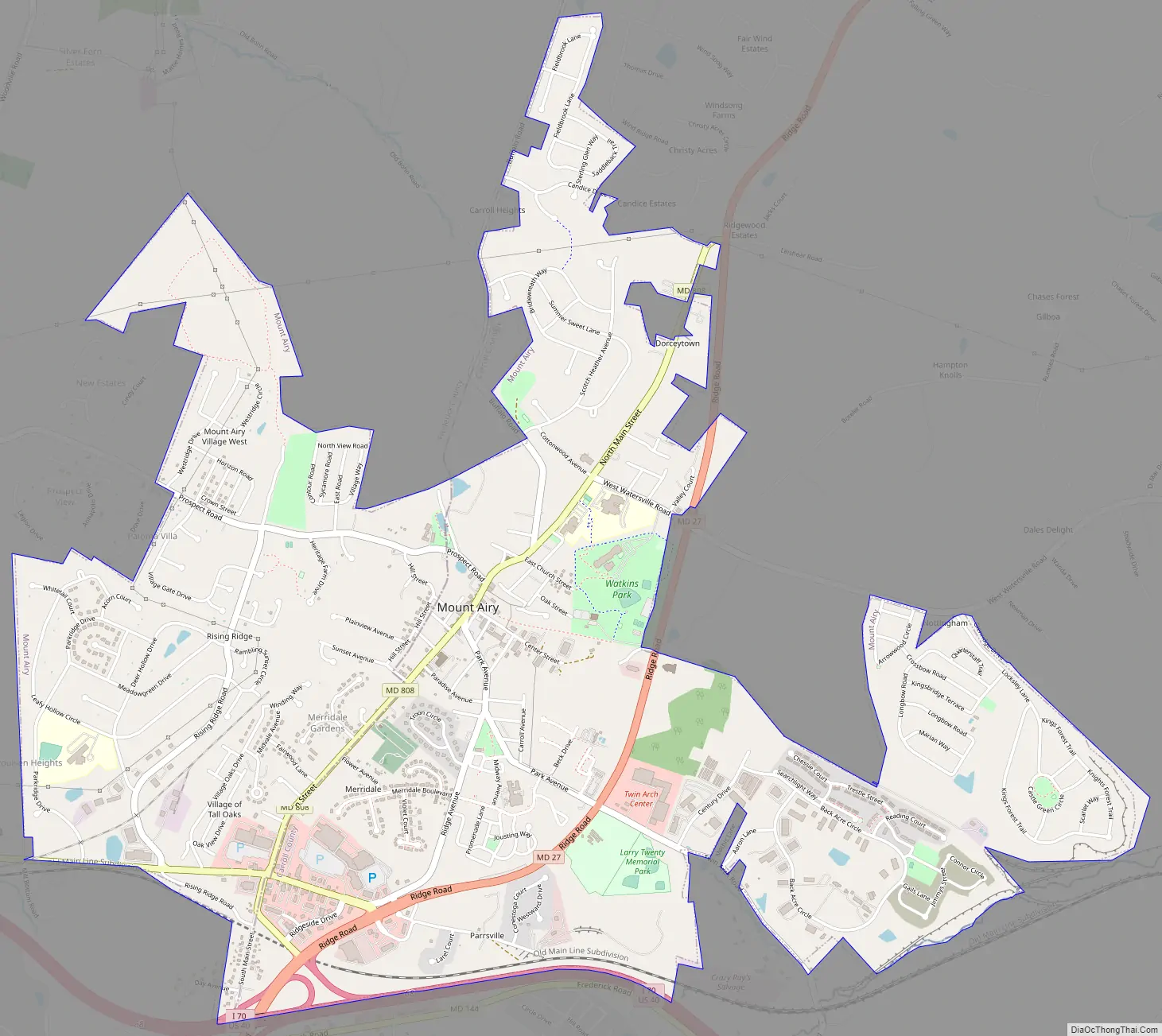
Mount Airy Road Map
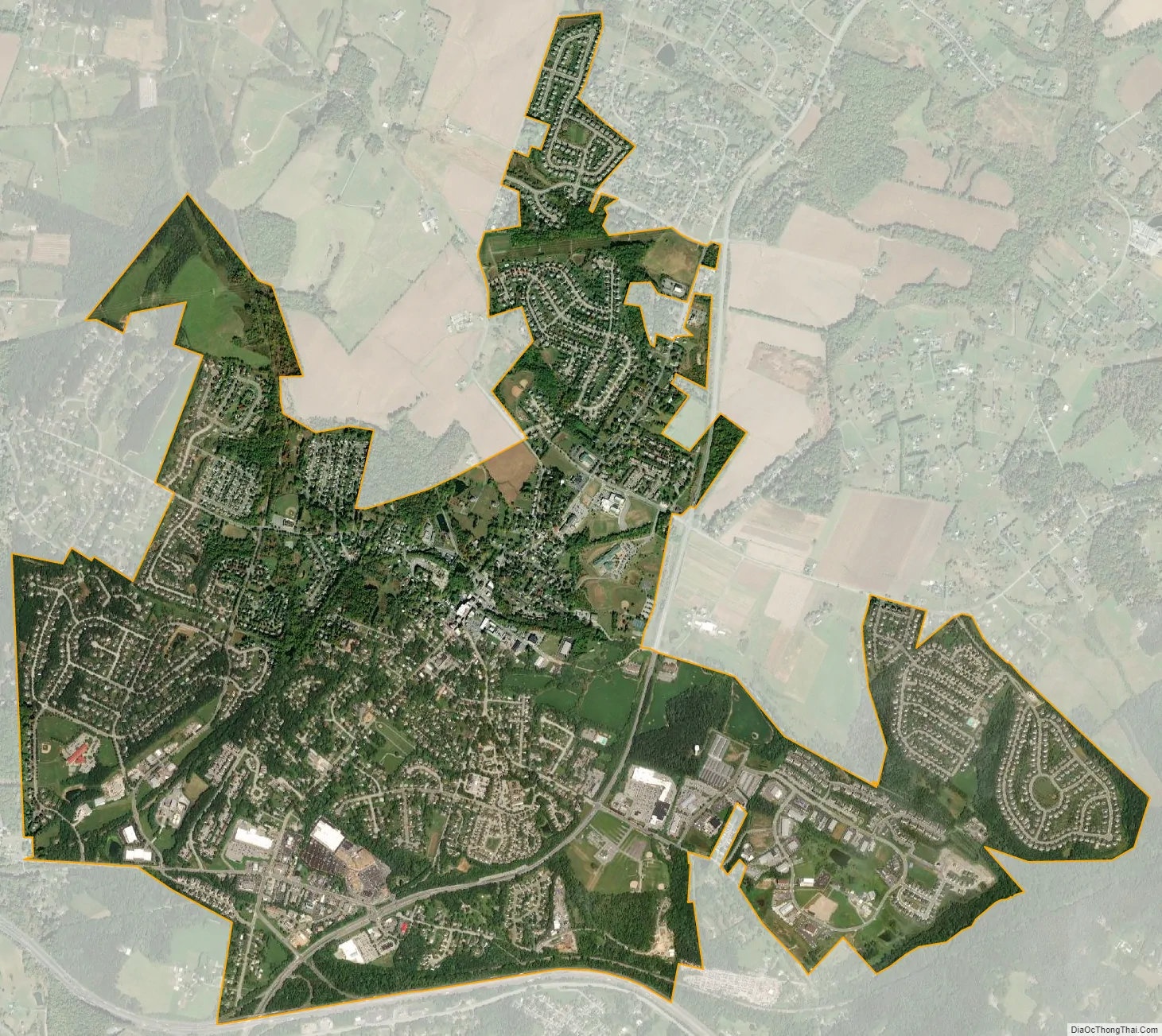
Mount Airy city Satellite Map
Geography
Mount Airy is located on the border between Frederick and Carroll counties, in the far eastern part of Frederick County and the southwest corner of Carroll County. Mount Airy’s Main Street, formerly MD 27 and now Maryland Route 808, runs atop Parrs Ridge in a northeast–southwest direction with elevations ranging between 800 and 850 feet (240 and 260 m). Numerous valleys that extend outward toward the east and west from this ridge give the town its unusually hilly topography. Mount Airy straddles the division of two major drainage basins. Within the Frederick County portion of the town are the headwaters of Woodville Branch and Ben’s Branch which are parts of the Linganore Creek watershed, as well as the headwaters of Bush Creek in the southwestern part of the town. The Linganore watershed drains into Lake Linganore, a secondary source of public water for Frederick County. The Linganore and Bush Creek watersheds are part of the Lower Monocacy River watershed, with eventual drainage to the Potomac River. The east side of Mount Airy drains via tributaries of Middle Run and the South Branch of the Patapsco River to Baltimore Harbor. Both the Potomac and the Patapsco are part of the Chesapeake Bay watershed.
According to the U.S. Census Bureau, the town of Mount Airy has a total area of 4.13 square miles (10.70 km), of which 4.12 square miles (10.67 km) is land and 0.01 square miles (0.03 km), or 0.29%, is water.
Transportation
The primary means of travel to and from Mount Airy are by road. The most prominent highway serving the town is Interstate 70 and U.S. Route 40, which forms the southern border of Mount Airy and leads east 32 miles (51 km) to Baltimore and west 14 miles (23 km) to Frederick. Maryland Route 27 (Ridge Road) runs through the east side of the town, leading northeast 16 miles (26 km) to Westminster, the Carroll County seat, and southwest 14 miles (23 km) to Interstate 270 in Germantown. Maryland Route 808 follows the original route of Maryland Route 27 through downtown Mount Airy.
Climate
Mount Airy is similar to Westminster in its position astride Parrs Ridge, and has a humid, temperate climate, more specifically a humid subtropical climate falling short of a humid continental climate, with four rather well defined seasons. The general atmospheric flow is from west to east but alternate surges of cold air from the north and of warm humid air from the south occurs in the area, causing highly variable weather. Nearness to the Atlantic Coast allows coastal storms to make up any deficiency of precipitation resulting from the passage of weather systems over the mountains to the west.
The average annual temperature is approximately 54 degrees, with January generally the coldest month and July the warmest. Temperatures exceed 90 degrees Fahrenheit an average of 27 days a year. The Town of Mount Airy is in the USDA Plant Hardiness Zone 7a for an annual extreme minimum temperature of 0-5 degrees Fahrenheit.
The average annual precipitation totals about 45 inches, with February the driest and August the wettest month. During the growing season, which averages about 177 days from April through to September, the last part of July through to the first part of August is the driest, with an average of 85-90 degrees. The average seasonal snowfall in Mount Airy per year is 28 inches, which is equal to the U.S. national average.
See also
Map of Maryland State and its subdivision: Map of other states:- Alabama
- Alaska
- Arizona
- Arkansas
- California
- Colorado
- Connecticut
- Delaware
- District of Columbia
- Florida
- Georgia
- Hawaii
- Idaho
- Illinois
- Indiana
- Iowa
- Kansas
- Kentucky
- Louisiana
- Maine
- Maryland
- Massachusetts
- Michigan
- Minnesota
- Mississippi
- Missouri
- Montana
- Nebraska
- Nevada
- New Hampshire
- New Jersey
- New Mexico
- New York
- North Carolina
- North Dakota
- Ohio
- Oklahoma
- Oregon
- Pennsylvania
- Rhode Island
- South Carolina
- South Dakota
- Tennessee
- Texas
- Utah
- Vermont
- Virginia
- Washington
- West Virginia
- Wisconsin
- Wyoming