Map of Perry Hall CDP
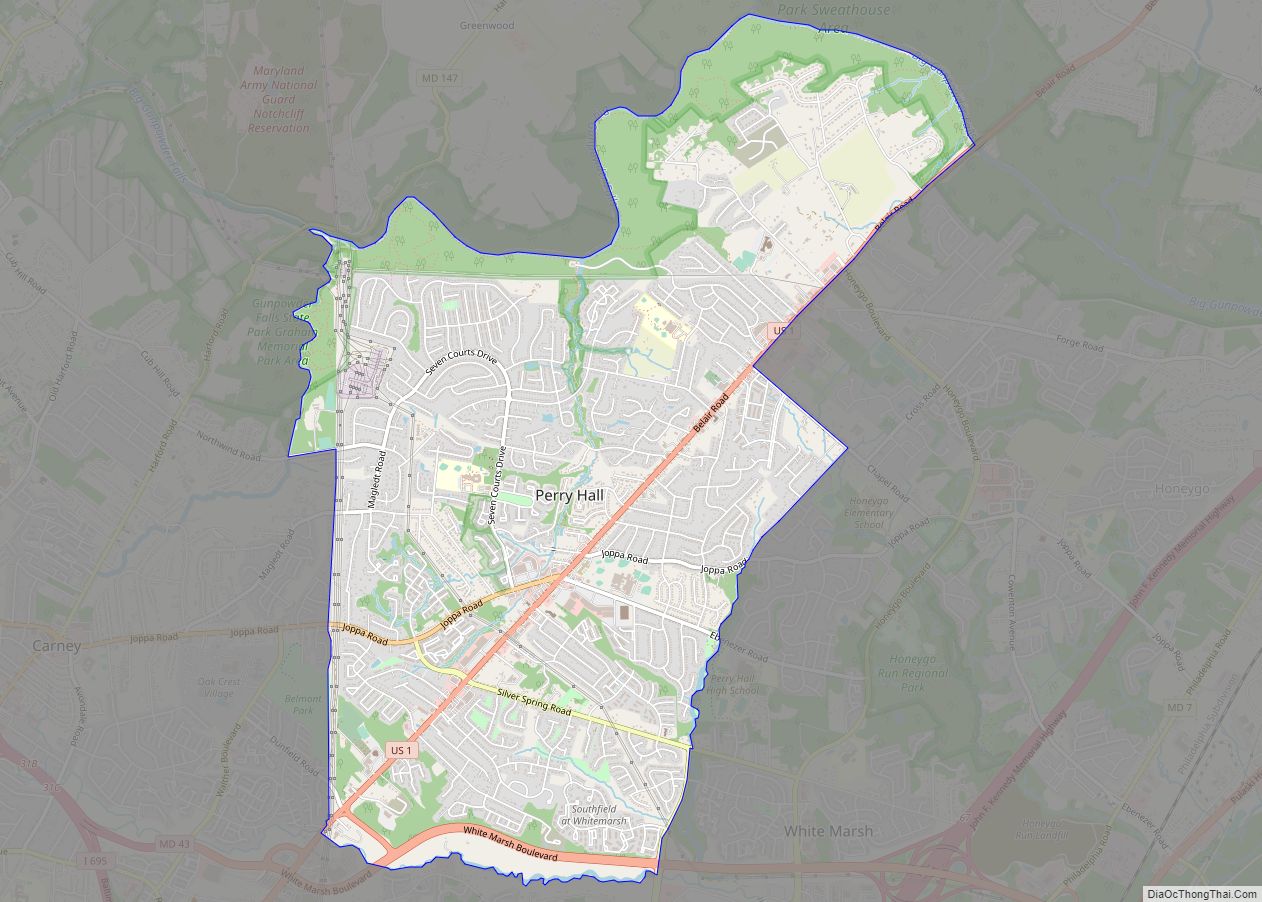
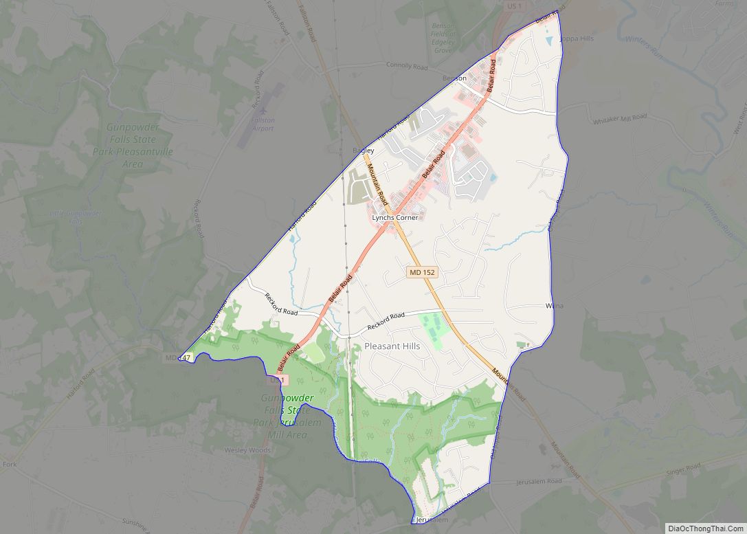
Perry Hall is an unincorporated community and census-designated place in Baltimore County, Maryland, United States. The population was 28,474 at the 2010 census. It is a suburb of Baltimore. Perry Hall CDP overview: Name: Perry Hall CDP LSAD Code: 57 LSAD Description: CDP (suffix) State: Maryland County: Baltimore County Elevation: 253 ft (77 m) Total Area: 6.94 sq mi ... Read more
Map of Perry Hall CDP
Map of Piney Point CDP
Piney Point (also known simply as “The Point“), is an unincorporated community and census-designated place in St. Mary’s County, Maryland, United States. It is known for the Paul Hall Center for Maritime Training and Education, houses along the beach, a lighthouse, and a museum. The Piney Point post office also serves St. George Island, which ... Read more
Map of Piney Point CDP
Map of Pinesburg CDP
Pinesburg is an unincorporated community and census-designated place in Washington County, Maryland, United States. Its population was 449 as of the 2010 census. Pinesburg CDP overview: Name: Pinesburg CDP LSAD Code: 57 LSAD Description: CDP (suffix) State: Maryland County: Washington County Elevation: 505 ft (154 m) Total Area: 0.73 sq mi (1.90 km²) Land Area: 0.73 sq mi (1.90 km²) Water Area: 0.00 sq mi ... Read more
Map of Pinesburg CDP
Map of Pikesville CDP
Pikesville is a census-designated place (CDP) in Baltimore County, Maryland, United States. Pikesville is just northwest of the Baltimore city limits. It is the northwestern suburb closest to Baltimore. The population was 30,764 at the 2010 census. The corridor along Interstate 795, which links Pikesville, Owings Mills and Reisterstown to the Baltimore Beltway (Interstate 695), ... Read more
Map of Pikesville CDP
Map of Pleasant Hills CDP, Maryland
Pleasant Hills is a census-designated place (CDP) in Harford County, Maryland, United States. The population was 3,379 at the 2010 census, up from 2,851 in 2000. There is no post office with the designation “Pleasant Hills”; most of the residents have either Fallston or Kingsville addresses and consider themselves as belonging to those communities. Pleasant ... Read more
Map of Pleasant Hills CDP, Maryland
Map of Pleasant Grove CDP, Maryland
Pleasant Grove is a census-designated place (CDP) in Allegany County, Maryland, United States. As of the 2010 census it had a population of 353. Pleasant Grove is located east of Cumberland along Maryland Route 144 (Baltimore Pike), the old alignment of U.S. Route 40. Interstate 68, the new highway alignment, also runs through the CDP, ... Read more
Map of Pleasant Grove CDP, Maryland
Map of Pittsville town, Maryland
Pittsville is a town in Wicomico County, Maryland, United States. The population was 1,417 at the 2010 census. It is included in the Salisbury, Maryland-Delaware Metropolitan Statistical Area. Pittsville town overview: Name: Pittsville town LSAD Code: 43 LSAD Description: town (suffix) State: Maryland County: Wicomico County Incorporated: 1906 Elevation: 52 ft (16 m) Total Area: 1.56 sq mi (4.04 km²) ... Read more
Map of Pittsville town, Maryland
Map of Pomfret CDP
Pomfret is a census-designated place in Charles County, Maryland, United States. As of the 2020 census, it had a population of 514. There are five properties in the area that are on the National Register of Historic Places. The origins of the settlement go back to at least 1666. Pomfret is located in central Charles ... Read more
Map of Pomfret CDP
Map of Point of Rocks CDP, Maryland
Point of Rocks is an unincorporated community and census-designated place (CDP) in Frederick County, Maryland, United States. As of the 2010 census it had a population of 1,466. It is named for the striking rock formation on the adjacent Catoctin Mountain, which was formed by the Potomac River cutting through the ridge in a water ... Read more
Map of Point of Rocks CDP, Maryland
Map of Pocomoke City
Pocomoke City, dubbed “the friendliest town on the Eastern Shore”, is a city in Worcester County, Maryland, United States. Although renamed in a burst of civic enthusiasm in 1878, the city is regularly referred to by its inhabitants simply as Pocomoke /ˈpoʊkoʊmoʊk/. The population was 4,184 at the 2010 census. It is part of the ... Read more
Map of Pocomoke City
Map of Port Deposit town
Port Deposit is a town in Cecil County, Maryland, United States. It is located on the east bank of the Susquehanna River near its discharge into the Chesapeake Bay. The population was 653 at the 2010 census. Port Deposit town overview: Name: Port Deposit town LSAD Code: 43 LSAD Description: town (suffix) State: Maryland County: ... Read more
Map of Port Deposit town
Map of Poolesville town
Poolesville is a U.S. town in the western portion of Montgomery County, Maryland. The population was 5,742 at the 2020 United States Census. It is surrounded by (but is technically not part of) the Montgomery County Agricultural Reserve, and is considered a distant bedroom community for commuters to Washington, D.C. The name of the town ... Read more
Map of Poolesville town