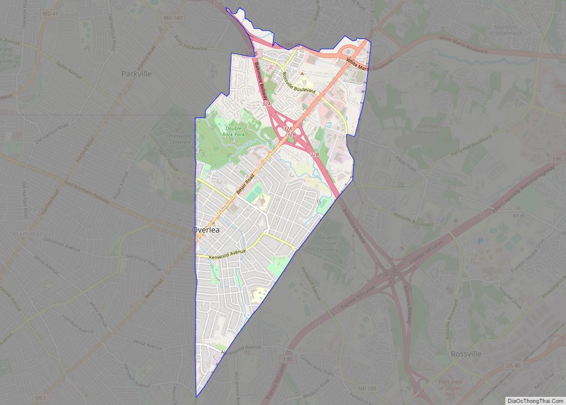
Overlea /ˈoʊvərˌliː/ is an unincorporated community and census-designated place in Baltimore County, Maryland, United States. The population was 12,275 at the 2010 census. Students attend Overlea High School. Area roads include Belair Road (U.S. Route 1) and Kenwood Avenue (Maryland Route 588). Overlea includes the neighborhood of Fullerton. Overlea CDP overview: Name: Overlea CDP LSAD ... Read more
Map of US Cities and Places
Paramount-Long Meadow is a census-designated place (CDP) in Washington County, Maryland, United States. The population was 2,722 at the 2000 census. Paramount-Long Meadow CDP overview: Name: Paramount-Long Meadow CDP LSAD Code: 57 LSAD Description: CDP (suffix) State: Maryland County: Washington County Total Area: 2.18 sq mi (5.65 km²) Land Area: 2.18 sq mi (5.65 km²) Water Area: 0.00 sq mi (0.00 km²) Total Population: ... Read more
Oxon Hill is an unincorporated area and census-designated place (CDP) in southern Prince George’s County, Maryland, United States. Oxon Hill is a suburb of Washington, located southeast of the downtown district and east of Alexandria, Virginia. It contains the new 300-acre (120 ha) National Harbor development on the shore of the Potomac River. For the 1990 ... Read more
Oxford is a waterfront town and former colonial port in Talbot County, Maryland, United States. The population was 651 at the 2010 census. Oxford town overview: Name: Oxford town LSAD Code: 43 LSAD Description: town (suffix) State: Maryland County: Talbot County Founded: 1683 (officially) Elevation: 7 ft (2 m) Total Area: 0.84 sq mi (2.17 km²) Land Area: 0.56 sq mi (1.45 km²) ... Read more
Parole, a suburb of Annapolis, is a census-designated place (CDP) in Anne Arundel County, Maryland, United States. The population was 15,922 at the 2010 census. It is where several major roads intersect at the western edge of the state capital, Annapolis, and contains the Annapolis Mall, and a number of other large shopping centers, and ... Read more
Parkville is an unincorporated community and census-designated place in Baltimore County, Maryland, United States. As of the 2010 census, the population was 30,734. Parkville CDP overview: Name: Parkville CDP LSAD Code: 57 LSAD Description: CDP (suffix) State: Maryland County: Baltimore County Elevation: 331 ft (101 m) Total Area: 4.29 sq mi (11.10 km²) Land Area: 4.29 sq mi (11.10 km²) Water Area: 0.00 sq mi ... Read more
Parsonsburg is an unincorporated community and census-designated place in Wicomico County, Maryland, United States. Its population was 339 as of the 2010 census. It is part of the Salisbury, Maryland-Delaware Metropolitan Statistical Area. Parsonsburg CDP overview: Name: Parsonsburg CDP LSAD Code: 57 LSAD Description: CDP (suffix) State: Maryland County: Wicomico County Elevation: 85 ft (26 m) Total ... Read more
Peppermill Village is an unincorporated community near Maryland Route 214 (Central Avenue) in Prince George’s County, Maryland, United States. Per the 2020 census, the population was 5,264. FedExField, Metrorail’s Blue Line, and Hampton Mall shopping center are all located nearby. Because it is not formally incorporated, it has no official boundaries, but the United States ... Read more
Pecktonville is an unincorporated community and census-designated place in Washington County, Maryland, United States. Its population was 167 as of the 2010 census. Pecktonville CDP overview: Name: Pecktonville CDP LSAD Code: 57 LSAD Description: CDP (suffix) State: Maryland County: Washington County Elevation: 404 ft (123 m) Total Area: 0.59 sq mi (1.52 km²) Land Area: 0.59 sq mi (1.52 km²) Water Area: 0.00 sq mi ... Read more
Pasadena is a census-designated place (CDP) in Anne Arundel County, Maryland, United States. The population was 24,287 at the 2010 census. The areas of Lake Shore, Riviera Beach and Pasadena are collectively referred to as Pasadena by residents. As all areas are governed by Anne Arundel County, there is no distinction in services such as ... Read more
Perryville is a town in Cecil County, Maryland, United States. The population was 4,361 at the 2010 census. The town is located near an exit for Interstate 95, on the north side of the outlet of the Susquehanna River. Perryville town overview: Name: Perryville town LSAD Code: 43 LSAD Description: town (suffix) State: Maryland County: ... Read more
Perryman is an unincorporated community and census-designated place (CDP) in Harford County, Maryland, United States. The population was 2,342 at the 2010 census. Perryman CDP overview: Name: Perryman CDP LSAD Code: 57 LSAD Description: CDP (suffix) State: Maryland County: Harford County Elevation: 39 ft (12 m) Total Area: 5.54 sq mi (14.36 km²) Land Area: 5.48 sq mi (14.20 km²) Water Area: 0.06 sq mi ... Read more