Map of Rossville CDP, Maryland
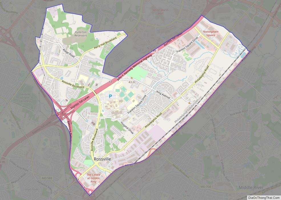
Rossville is an unincorporated community and census-designated place in Baltimore County, Maryland, United States. The population was 15,147 at the 2010 census. Rossville CDP overview: Name: Rossville CDP LSAD Code: 57 LSAD Description: CDP (suffix) State: Maryland County: Baltimore County Elevation: 43 ft (13 m) Total Area: 5.40 sq mi (13.99 km²) Land Area: 5.38 sq mi (13.93 km²) Water Area: 0.02 sq mi (0.06 km²) ... Read more
Map of Rossville CDP, Maryland
Map of Savage CDP, Maryland
Savage is an unincorporated community and census-designated place located in Howard County, Maryland, United States, approximately 18 miles (29 km) south of Baltimore and 21 miles (34 km) north of Washington, D.C. It is situated close to the city of Laurel and to the planned community of Columbia. As of the 2020 census, it had a population ... Read more
Map of Savage CDP, Maryland
Map of Sandy Hook CDP, Maryland
Sandy Hook is an unincorporated community and census-designated place in Washington County, Maryland, United States. Its population was 188 as of the 2010 census. Sandy Hook was briefly important as for a few years it was the end of the line for the Baltimore and Ohio Railroad, then under construction. This period ended with the ... Read more
Map of Sandy Hook CDP, Maryland
Map of San Mar CDP
San Mar is a census-designated place (CDP) in Washington County, Maryland, United States. The population was 515 at the 2000 census. San Mar CDP overview: Name: San Mar CDP LSAD Code: 57 LSAD Description: CDP (suffix) State: Maryland County: Washington County Elevation: 545 ft (166 m) Total Area: 0.47 sq mi (1.21 km²) Land Area: 0.47 sq mi (1.21 km²) Water Area: 0.00 sq mi ... Read more
Map of San Mar CDP
Map of Seat Pleasant city
Seat Pleasant is an incorporated city in Prince George’s County, Maryland, United States, located immediately east of Washington. Per the 2020 census, the population was 4,522. Two state highways pass through the community — Maryland routes 704 (now called Martin Luther King Jr. Highway and previously named George Palmer Highway in honor of banker and ... Read more
Map of Seat Pleasant city
Map of Seabrook CDP, Maryland
Seabrook is an unincorporated community and census-designated place (CDP) in Prince George’s County, Maryland, United States, located approximately 12 miles (19 km) east of Washington, D.C.. Per the 2020 census, the population was 19,627. Prior to 2010, Seabrook was part of the Lanham-Seabrook census-designated place. Seabrook CDP overview: Name: Seabrook CDP LSAD Code: 57 LSAD Description: ... Read more
Map of Seabrook CDP, Maryland
Map of Scaggsville CDP
Scaggsville is an unincorporated community and census-designated place in Howard County, Maryland, United States. It is situated near the southeastern tip of Howard County, between Laurel and Fulton. As of the 2010 census it had a population of 24,333. The town mainly consists of residences, with some commercial establishments. Scaggsville generally falls within ZIP code ... Read more
Map of Scaggsville CDP
Map of Severna Park CDP
Severna Park is a census-designated place (CDP) in Anne Arundel County, Maryland, United States. Severna Park is part of the Baltimore-Washington Metropolitan Area, and is located approximately 8 miles (13 km) north of Annapolis, 17 miles (27 km) south of Baltimore and 39 miles (63 km) east of Washington, D.C. Severna Park’s population was 39,933 at the 2020 ... Read more
Map of Severna Park CDP
Map of Severn CDP, Maryland
Severn is a census-designated place (CDP) in Anne Arundel County, Maryland, United States. According to the 2020 U.S. census, the population of Severn is 57,118, a 22.6% increase from 44,231 in 2010. The zip code is 21144. Severn CDP overview: Name: Severn CDP LSAD Code: 57 LSAD Description: CDP (suffix) State: Maryland County: Anne Arundel ... Read more
Map of Severn CDP, Maryland
Map of Secretary town
Secretary is a town in Dorchester County, Maryland, United States. The population was 535 at the 2010 census. Lord Baltimore named the town after his secretary. Secretary town overview: Name: Secretary town LSAD Code: 43 LSAD Description: town (suffix) State: Maryland County: Dorchester County Incorporated: 1900 Elevation: 20 ft (6 m) Total Area: 0.29 sq mi (0.75 km²) Land Area: ... Read more
Map of Secretary town
Map of Sharpsburg town, Maryland
Sharpsburg is a town in Washington County, Maryland. The town is approximately 13 miles (21 km) south of Hagerstown. Its population was 705 at the 2010 census. During the American Civil War, the Battle of Antietam, sometimes referred to as the Battle of Sharpsburg, was fought on what is now Antietam National Battlefield, in the vicinity ... Read more
Map of Sharpsburg town, Maryland
Map of Shaft CDP
Shaft is a census-designated place (CDP) corresponding to the unincorporated community of Borden Shaft in Allegany County, Maryland, United States. As of the 2010 census, the CDP had a population of 235. It is located south of Frostburg, in the Georges Creek Valley. It lies at an elevation of 1,795 feet (547 m). Borden, or Borden ... Read more
Map of Shaft CDP