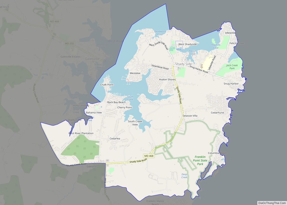
Shady Side is a census-designated place (CDP) in Anne Arundel County, Maryland, United States. The population was 5,803 at the 2010 census. Shady Side CDP overview: Name: Shady Side CDP LSAD Code: 57 LSAD Description: CDP (suffix) State: Maryland County: Anne Arundel County Elevation: 9 ft (3 m) Total Area: 7.86 sq mi (20.35 km²) Land Area: 6.65 sq mi (17.22 km²) Water ... Read more
Map of US Cities and Places
Smith Island is a collection of three distinct island communities, Tylerton, Rhodes Point, and Ewell, Maryland on the Chesapeake Bay, on the border of Maryland and Virginia territorial waters in the United States. The island is the last inhabited island in Maryland that is not accessible by vehicle, where most of the islands are eroding ... Read more
Silver Hill is an unincorporated community and census-designated place (CDP) in Prince George’s County, Maryland, United States, approximately 1 mile (1.6 km) southeast of Washington, D.C. Per the 2020 census, the population was 6,381. Prior to 2010, Silver Hill was part of the Suitland-Silver Hill census-designated place. Silver Hill CDP overview: Name: Silver Hill CDP LSAD ... Read more
Sharptown is a town in Wicomico County, Maryland, United States. The population was 651 at the 2010 census. It is included in the Salisbury, Maryland-Delaware Metropolitan Statistical Area. Sharptown town overview: Name: Sharptown town LSAD Code: 43 LSAD Description: town (suffix) State: Maryland County: Wicomico County Incorporated: 1874 Elevation: 10 ft (3 m) Total Area: 0.42 sq mi (1.09 km²) ... Read more
Smithsburg is a town in Washington County, Maryland, United States. The population was 2,975 at the 2010 census. Smithsburg is close to the former Fort Ritchie army base and just west of the presidential retreat Camp David. Smithsburg town overview: Name: Smithsburg town LSAD Code: 43 LSAD Description: town (suffix) State: Maryland County: Washington County ... Read more
Solomons, also known as Solomons Island, is an unincorporated community and census-designated place (CDP) in Calvert County, Maryland, United States. The population was 2,368 at the 2010 census, up from 1,536 in 2000. Solomons is a popular weekend destination spot in the Baltimore–Washington metropolitan area. Solomons CDP overview: Name: Solomons CDP LSAD Code: 57 LSAD ... Read more
Snow Hill is a town and the county seat of Worcester County, Maryland, United States. The population was 2,103 at the 2010 census. It is part of the Salisbury, Maryland-Delaware Metropolitan Statistical Area. Snow Hill town overview: Name: Snow Hill town LSAD Code: 43 LSAD Description: town (suffix) State: Maryland County: Worcester County Incorporated: 1812 ... Read more
South Laurel is an unincorporated area and census-designated place (CDP) in Prince George’s County, Maryland, United States. Per the 2020 census, the population was 29,602. South Laurel CDP overview: Name: South Laurel CDP LSAD Code: 57 LSAD Description: CDP (suffix) State: Maryland County: Prince George’s County Elevation: 161 ft (49 m) Total Area: 8.10 sq mi (20.99 km²) Land Area: ... Read more
South Kensington is a census-designated place and an unincorporated area in Montgomery County, Maryland, United States. It had a population of 8,829 in 2020. South Kensington CDP overview: Name: South Kensington CDP LSAD Code: 57 LSAD Description: CDP (suffix) State: Maryland County: Montgomery County Elevation: 285 ft (87 m) Total Area: 2.13 sq mi (5.52 km²) Land Area: 2.09 sq mi (5.42 km²) ... Read more
Somerset is an incorporated town in Montgomery County, Maryland, United States, located near its border with Washington, D.C. The population was 1,216 at the 2010 census. Somerset has no relationship to Somerset County, some 150 miles distant. Somerset town overview: Name: Somerset town LSAD Code: 43 LSAD Description: town (suffix) State: Maryland County: Montgomery County ... Read more
Spring Ridge is census-designated place (CDP) and suburban housing community in Frederick County, in the U.S. state of Maryland, just outside the city of Frederick. As of the 2020 census it had a population of 6,005. Before 2010, it was part of the Linganore-Bartonsville, Maryland census-designated place, which was split into three for the 2010 ... Read more
Spring Gap is an unincorporated community and census-designated place (CDP) in Allegany County, Maryland, United States. As of the 2010 census it had a population of 55. Spring Gap is located in the valley of the North Branch Potomac River along the Chesapeake and Ohio (C&O) Canal at mile marker 173. Just west of the ... Read more