Map of Riva CDP
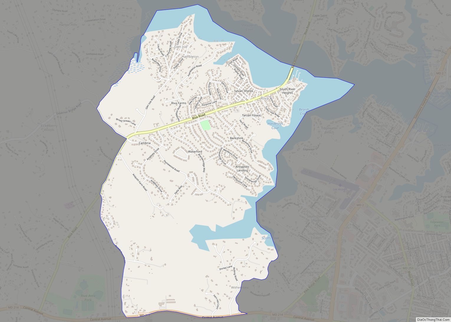
Riva is a census-designated place (CDP) in Anne Arundel County, Maryland, United States. The population was 4,076 at the 2010 census. The area is scenic, especially where the two-lane Riva Road crosses the South River on a bridge. The area is growing with large new homes as the suburbs of Annapolis grow outward. Riva is ... Read more
Map of Riva CDP
Map of Rock Hall town
Rock Hall, is a waterfront town located directly on the National Chesapeake Scenic Byway in Kent County, Maryland, United States. The population was 1,310 at the 2010 census. Rock Hall town overview: Name: Rock Hall town LSAD Code: 43 LSAD Description: town (suffix) State: Maryland County: Kent County Founded: 1707 Incorporated: 1908 Elevation: 10 ft (3 m) ... Read more
Map of Rock Hall town
Map of Robinwood CDP
Robinwood is a census-designated place (CDP) in Washington County, Maryland, United States. The population was 4,731 at the 2000 census. It is a part of the Hagerstown Metropolitan Area. Robinwood is home to Hagerstown Community College. Robinwood CDP overview: Name: Robinwood CDP LSAD Code: 57 LSAD Description: CDP (suffix) State: Maryland County: Washington County Total ... Read more
Map of Robinwood CDP
Map of Riviera Beach CDP, Maryland
Riviera Beach is a census-designated place in Anne Arundel County, Maryland, United States. The population was 12,677 at the 2010 U.S. census. Riviera Beach CDP overview: Name: Riviera Beach CDP LSAD Code: 57 LSAD Description: CDP (suffix) State: Maryland County: Anne Arundel County Elevation: 10 ft (3 m) Total Area: 3.21 sq mi (8.31 km²) Land Area: 2.63 sq mi (6.81 km²) Water ... Read more
Map of Riviera Beach CDP, Maryland
Map of Rohrersville CDP
Rohrersville is a census-designated place (CDP) in Washington County, Maryland, United States. The population was 175 at the 2010 census. Rohrersville CDP overview: Name: Rohrersville CDP LSAD Code: 57 LSAD Description: CDP (suffix) State: Maryland County: Washington County Elevation: 630 ft (192 m) Total Area: 0.35 sq mi (0.90 km²) Land Area: 0.35 sq mi (0.90 km²) Water Area: 0.00 sq mi (0.00 km²) Total Population: ... Read more
Map of Rohrersville CDP
Map of Rockville city, Maryland
Rockville is a city that serves as the county seat of Montgomery County, Maryland, United States, and is part of the Baltimore–Washington metropolitan area. The 2020 census tabulated Rockville’s population at 67,117, making it the fifth-largest community in Montgomery County. Rockville, along with neighboring Gaithersburg and Bethesda, is at the core of the Interstate 270 ... Read more
Map of Rockville city, Maryland
Map of Rock Point CDP, Maryland
Rock Point is an unincorporated community and census-designated place in Charles County, Maryland, United States. Rock Point CDP overview: Name: Rock Point CDP LSAD Code: 57 LSAD Description: CDP (suffix) State: Maryland County: Charles County Total Area: 0.63 sq mi (1.63 km²) Land Area: 0.63 sq mi (1.63 km²) Water Area: 0.00 sq mi (0.00 km²) Total Population: 82 Population Density: 130.37/sq mi (50.34/km²) FIPS ... Read more
Map of Rock Point CDP, Maryland
Map of Rosemont village, Maryland
Rosemont is a village in Frederick County, Maryland, United States. The population was 272 at the 2020 census. Maryland state routes 79 and 871 pass through Rosemont. Rosemont village overview: Name: Rosemont village LSAD Code: 47 LSAD Description: village (suffix) State: Maryland County: Frederick County Incorporated: 1953 Elevation: 502 ft (153 m) Total Area: 0.56 sq mi (1.44 km²) Land ... Read more
Map of Rosemont village, Maryland
Map of Rosedale CDP, Maryland
Rosedale is an unincorporated community and census-designated place in Baltimore County, Maryland, United States. The population was 19,257 at the 2010 United States Census. Rosedale CDP overview: Name: Rosedale CDP LSAD Code: 57 LSAD Description: CDP (suffix) State: Maryland County: Baltimore County Elevation: 20 ft (6 m) Total Area: 7.10 sq mi (18.40 km²) Land Area: 6.86 sq mi (17.78 km²) Water Area: ... Read more
Map of Rosedale CDP, Maryland
Map of Rosaryville CDP
Rosaryville is an unincorporated area and census-designated place (CDP) in Prince George’s County, Maryland, United States, located south of Cinton and Upper Marlboro beside U.S. Route 301. Per the 2020 census, the population was 11,548. including housing developments and rural open space. It was named for a local Roman Catholic church. Close to Rosaryville are ... Read more
Map of Rosaryville CDP
Map of Salisbury city, Maryland
Salisbury (/ˈsɔːlzbəri/ SAWLZ-bear-ee) is a city in and the county seat of Wicomico County, Maryland, United States. Salisbury is the largest city in the state’s Eastern Shore region, with a population was 33,050 at the 2020 census. Salisbury is the principal city of the Salisbury, Maryland-Delaware Metropolitan Statistical Area. The city is the commercial hub ... Read more
Map of Salisbury city, Maryland
Map of Sabillasville CDP
Sabillasville is an unincorporated community and census-designated place in Frederick County, Maryland, United States. As of the 2010 census it had a population of 354. The Victor Cullen School Power House was listed on the National Register of Historic Places in 1987 and the Victor Cullen Center, Old Administration Building was listed in 1990. Sabillasville ... Read more
Map of Sabillasville CDP