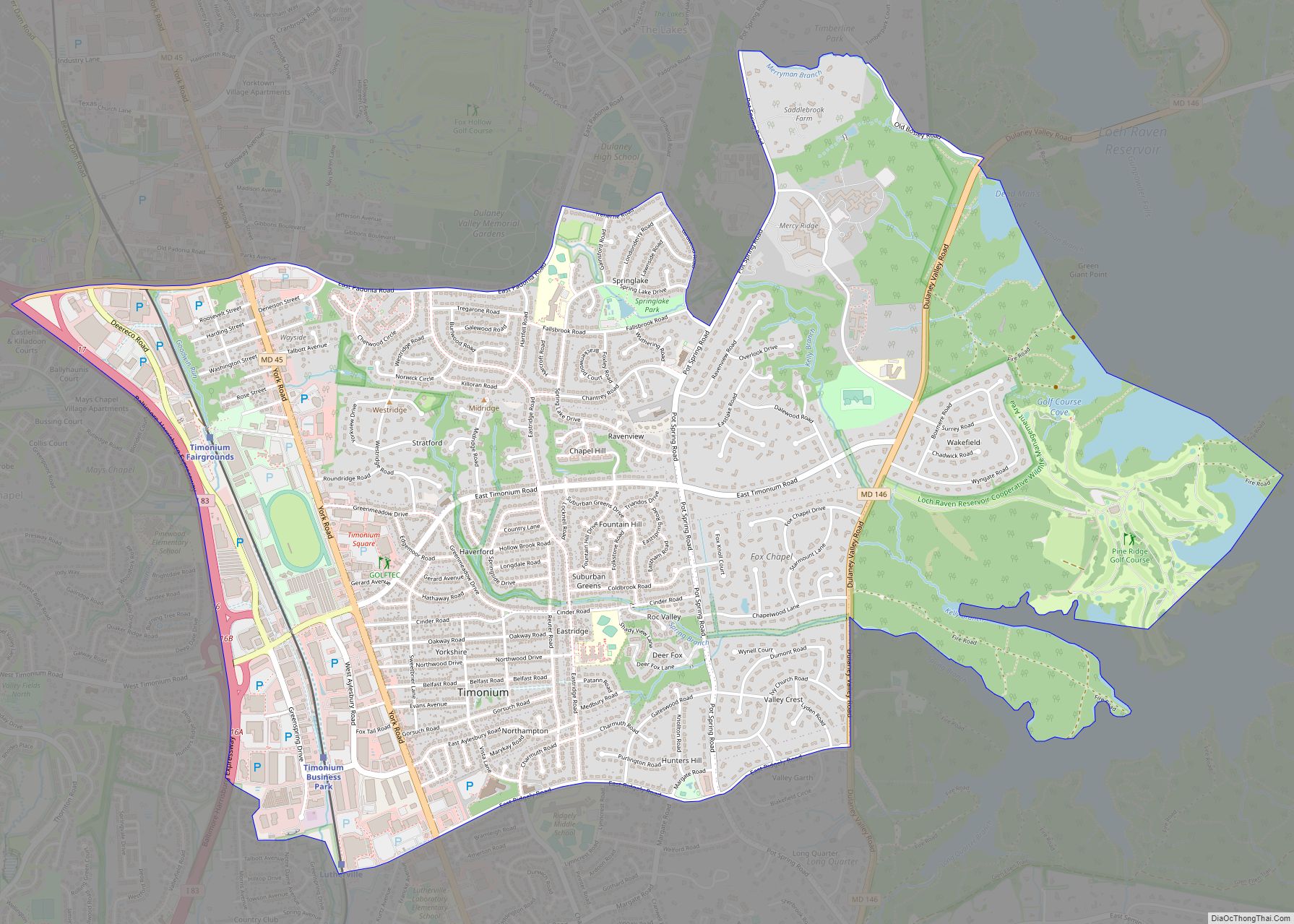
Timonium /ˌtɪˈmoʊniːəm/ is a census-designated place (CDP) in Baltimore County, Maryland, United States. As of the 2010 census it had a population of 9,926. Prior to 2010 the area was part of the Lutherville-Timonium CDP. The Maryland State Fair is held in Timonium each year near Labor Day on the grounds of the former Timonium ... Read more
Map of US Cities and Places
Trego-Rohrersville Station is an unincorporated community and census-designated place in Washington County, Maryland, United States. Its population was 160 as of the 2020 census. Trego-Rohrersville Station CDP overview: Name: Trego-Rohrersville Station CDP LSAD Code: 57 LSAD Description: CDP (suffix) State: Maryland County: Washington County Total Area: 0.43 sq mi (1.10 km²) Land Area: 0.43 sq mi (1.10 km²) Water Area: 0.00 sq mi ... Read more
Travilah is a United States census-designated place and an unincorporated area in Montgomery County, Maryland. It is 17.28 square miles (44.8 km) located along the north side of the Potomac River, and surrounded by the communities of Potomac, North Potomac, and Darnestown—all census-designated places. It had a population of 11,985 as of the 2020 census. Within ... Read more
Trappe is a town in Talbot County, Maryland, United States. The population was 1,077 at the 2010 census. It is the site of one of the largest mixed-use developments on the U.S. East Coast called Trappe East or “Lakeside” with controversy arising over its wastewater treatment. Trappe town overview: Name: Trappe town LSAD Code: 43 ... Read more
Tyaskin is an unincorporated community and census-designated place in Wicomico County, Maryland, United States. Its population was 236 as of the 2010 census. It is part of the Salisbury, Maryland-Delaware Metropolitan Statistical Area. Beaudley was listed on the National Register of Historic Places in 2001. Tyaskin CDP overview: Name: Tyaskin CDP LSAD Code: 57 LSAD ... Read more
University Park is a town in Prince George’s County, Maryland, United States. The population was 2,548 at the 2010 census. University Park town overview: Name: University Park town LSAD Code: 43 LSAD Description: town (suffix) State: Maryland County: Prince George’s County Incorporated: 1936 Elevation: 72 ft (22 m) Total Area: 0.50 sq mi (1.30 km²) Land Area: 0.50 sq mi (1.30 km²) Water ... Read more
Union Bridge is a town in Carroll County, Maryland, United States. The population was 936 at the 2020 census. Much of the town was added to the National Register of Historic Places as the Union Bridge Historic District in 1994. Union Bridge town overview: Name: Union Bridge town LSAD Code: 43 LSAD Description: town (suffix) ... Read more
Vale Summit is an unincorporated community and census-designated place (CDP) in Allegany County, Maryland, United States. As of the 2010 census it had a population of 139. Local lore indicates that the community was so named in the mid 19th century, founded by the local population of coal miners. Previously, however, it was locally known ... Read more
Urbana (/ərˈbænə/ ər-BAN-ə) is a suburban census-designated place located in Frederick County, Maryland, United States. It lies at the I-270/MD 80 interchange, approximately 7.5 miles (12.1 km) south-east of Frederick and about 37 miles (60 km) north-west of Washington, D.C. Urbana started to develop circa 1999 and, as of the 2010 census, had a population of 9,175. ... Read more
Upper Marlboro, officially the Town of Upper Marlboro, is the seat of Prince George’s County, Maryland. As of the 2020 census, the population within the town limits was 652, although Greater Upper Marlboro, which covers a large area outside the town limits, is many times larger. Upper Marlboro town overview: Name: Upper Marlboro town LSAD ... Read more
Walkersville is a town in Frederick County, Maryland, United States. The population was 5,800 at the 2010 census. Walkersville town overview: Name: Walkersville town LSAD Code: 43 LSAD Description: town (suffix) State: Maryland County: Frederick County Incorporated: 1892 Elevation: 308 ft (94 m) Total Area: 4.77 sq mi (12.34 km²) Land Area: 4.76 sq mi (12.34 km²) Water Area: 0.00 sq mi (0.01 km²) Total Population: ... Read more
Walker Mill is an unincorporated area and census-designated place (CDP) in Prince George’s County, Maryland, United States. Per the 2020 census, the population was 12,187. Walker Mill CDP overview: Name: Walker Mill CDP LSAD Code: 57 LSAD Description: CDP (suffix) State: Maryland County: Prince George’s County Elevation: 203 ft (62 m) Total Area: 3.02 sq mi (7.81 km²) Land Area: ... Read more