Upper Marlboro, officially the Town of Upper Marlboro, is the seat of Prince George’s County, Maryland. As of the 2020 census, the population within the town limits was 652, although Greater Upper Marlboro, which covers a large area outside the town limits, is many times larger.
| Name: | Upper Marlboro town |
|---|---|
| LSAD Code: | 43 |
| LSAD Description: | town (suffix) |
| State: | Maryland |
| County: | Prince George’s County |
| Incorporated: | 1870 |
| Elevation: | 23 ft (7 m) |
| Total Area: | 0.74 sq mi (1.91 km²) |
| Land Area: | 0.69 sq mi (1.79 km²) |
| Water Area: | 0.05 sq mi (0.12 km²) |
| Total Population: | 652 |
| Population Density: | 946.30/sq mi (365.17/km²) |
| Area code: | 301, 240 |
| FIPS code: | 2479875 |
| GNISfeature ID: | 0598208 |
| Website: | www.uppermarlboromd.gov |
Online Interactive Map
Click on ![]() to view map in "full screen" mode.
to view map in "full screen" mode.
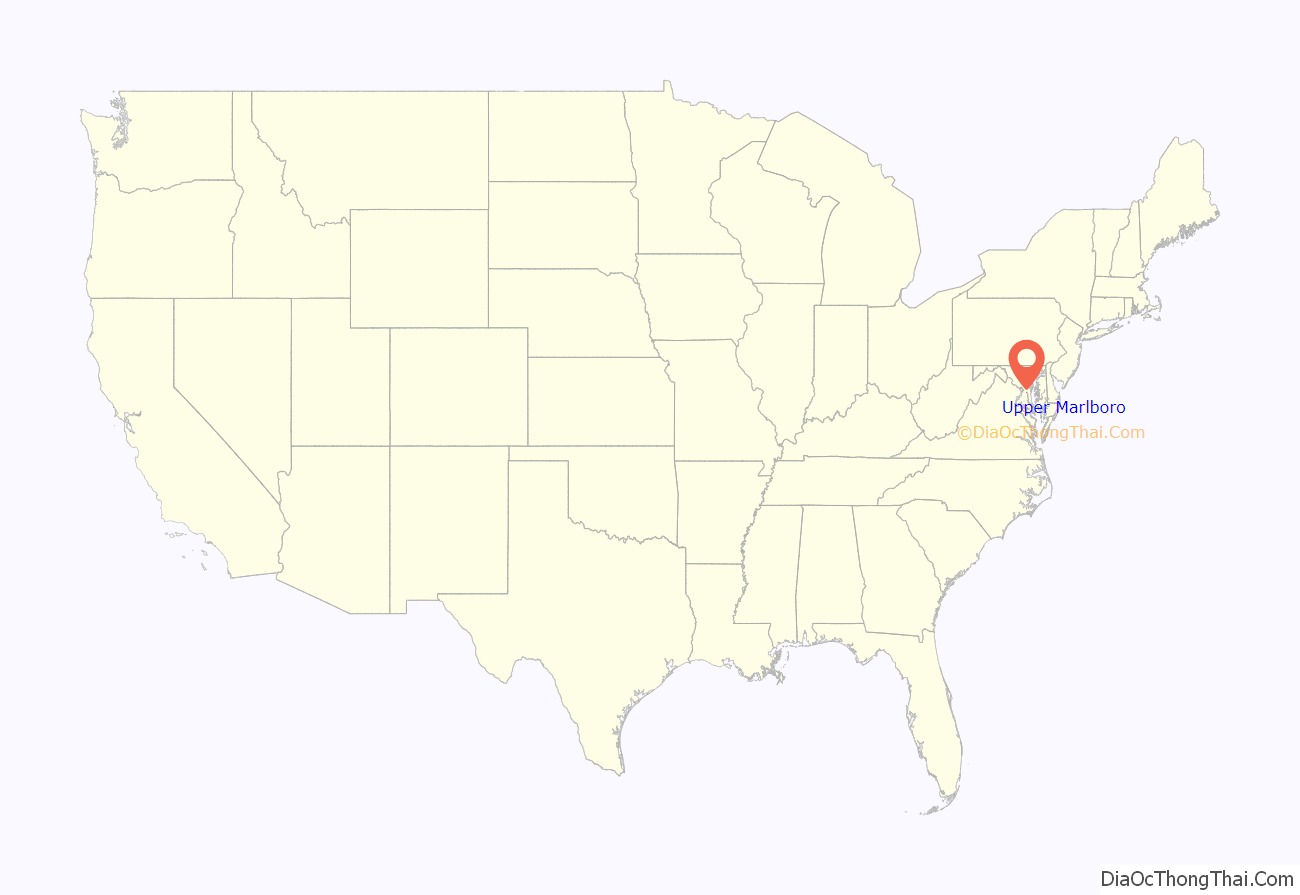
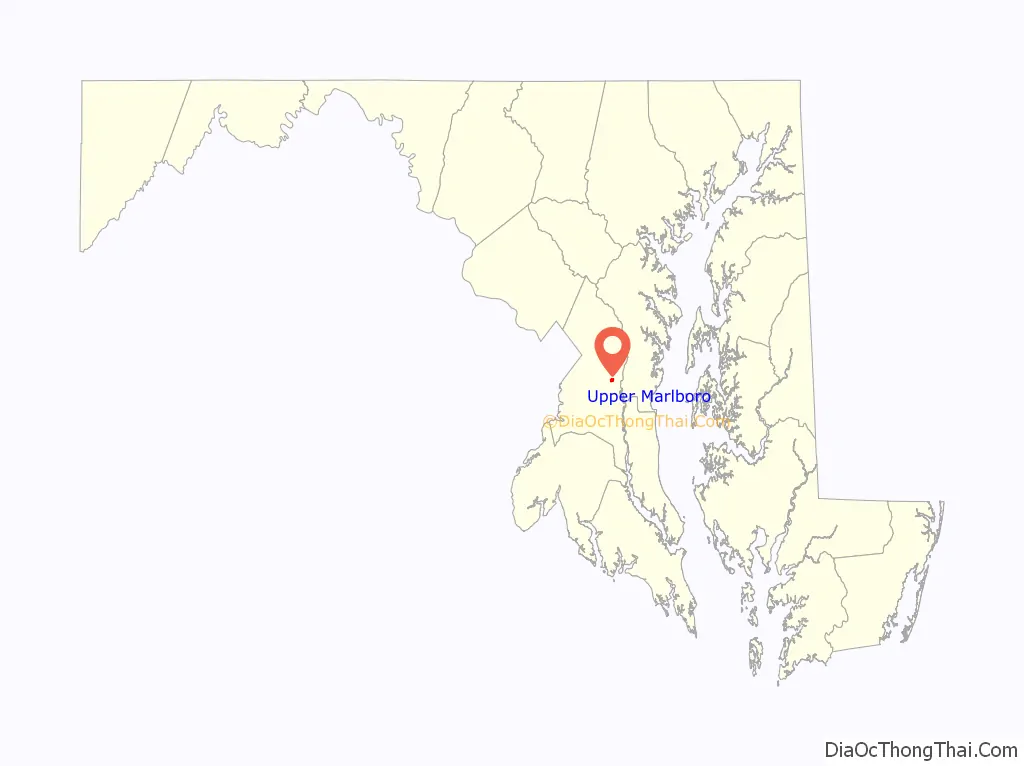
Upper Marlboro location map. Where is Upper Marlboro town?
History
The area of Upper Marlboro was first settled around 1695. It was named after John Churchill, 1st Duke of Marlborough, an ancestor of Winston Churchill. The land, which was to become the town, was part of several estates known as Grove Landing, Meadows, and Darnall’s Chance, owned by the Brooke, Beall, and Darnall families, respectively.
Darnall’s Chance, also known as the Buck House, Buck-Wardrop House, or James Wardrop House, is a historic home located at 14800 Governor Oden Bowie Drive, in Upper Marlboro. It is named after Colonel Henry Darnall, a wealthy Roman Catholic planter, who was the Proprietary Agent of Charles Calvert, 3rd Baron Baltimore and who served for a time as Deputy Governor of the Province. The house itself was built c. 1742 by a merchant named James Wardrop, after he bought some of the land from Eleanor Darnall Carroll and her husband. Today, Darnall’s Chance houses the Darnall’s Chance House Museum, an historic house museum that opened to the public in 1988.
In 1706, Marlborough Town was established as a port town by the Act for the Advancement of Trade and Erecting Ports and Towns. It was declared that the town would be constructed, “at the upper landing on the Western Branch, commonly called Colonel Belt’s landing.” County surveyor Thomas Truman Greenfield conducted a survey of 100 acres (0.40 km) of the three estates from which the town would be formed. Streets, alleys, a meetinghouse, lots for small businesses, and 100 lots to be used for homes were laid out. The earliest plans showed the town being laid out in a grid pattern with an L shape. In 1718 residents asked the county government’s general assembly, then based in Charles Town, via petition to move the county seat to Upper Marlboro. The county seat has been there since that time.
Residents of the area were not happy with Greenfield’s initial layout and petitioned the General Assembly to have the town replatted. In 1744, the new survey was approved and the town was given a new name, Upper Marlborough. Upper was added to distinguish the town from the community of Marlboro (now known as Lower Marlboro) in Calvert County.
Early in its life, when the western branch of the Patuxent River was still navigable, the town served as a port town for tobacco ships. The town blossomed into an agricultural, social, and political hot spot. Farms, many of which raised tobacco, dominated the surrounding areas.
In 1721, a courthouse was constructed in the town. The county seat was then moved from Charles Town, on the banks of the Patuxent, to Upper Marlborough. The courthouse was built with money from a 12-pound tobacco tax imposed on county inhabitants. One of the first laws passed at the courthouse was the Public School Act, which established a public school system.
In 1814, Upper Marlboro was seized by British forces under the command of Major-General Robert Ross and Rear Admiral George Cockburn during the campaign leading up to the Battle of Bladensburg and the Burning of Washington.
During the late 18th and early 19th centuries, many prominent merchants, lawyers, and politicians lived and worked in the area. Horse racing came to the town around the mid-18th century and attracted many people from the surrounding areas. The Maryland Jockey Club sponsored spring and summer races at the race track south of town, and racing continued there until 1972, when they were moved to the Bowie Race Track. The race track is now part of the Equestrian Center owned by Prince George’s County.
In 1870, the town was incorporated by the Maryland General Assembly. A volunteer fire department was organized in 1886, and the Marlborough Fire Association was incorporated the following year.
In 1878, Michael Green, an African-American man accused of assaulting a white woman, was taken from the country jail and hanged from a tree outside of town. An “iron bridge just between the town and the railroad depot” was the site of two more lynchings. Joseph Vermillion was killed there in 1889 and Stephen Williams met the same fate in 1894.
Since its initial conception, the town has changed quite a bit. It initially boomed as a port town for tobacco trade, but the clearing and cultivation of land for farming would lead to erosion in the area. Over the years this erosion caused sedimentation, leading the Western Branch to become unnavigable. The fields of tobacco that once dominated the area have been converted over to residential developments, with the number of farms dwindling each year.
As it is Prince George’s county seat, located within the town are the Prince George’s County Courthouse, County Administration Building, the Board of Education, and the headquarters of the Prince George’s County Sheriff’s Office. The town’s atmosphere is remarkably different, depending on the time of day.
Prince George’s County courthouse
The courthouse has been a critical part of the town since it became the county seat in 1721. Since then, the courthouse in Upper Marlboro has seen many changes. Between 1798 and 1801, a new courthouse was constructed on the site of the old one. The courthouse was again rebuilt in the 1880s.
In 1939, the courthouse was substantially expanded and rebuilt. During this time, the building gained its famous stone Ionic columns. According to county historian Susan Pearl, “They wanted the neo-classic Georgian university campus building, and that’s what they got.” The total cost of the revision was $178,000.
Small additions were made in 1947 and 1969.
In the early 1990s, a new courthouse was erected behind the existing courthouse. The new courthouse, composed of the Marbury and Bourne wing, was completed in 1991. The new building occupies 360,000 square feet (33,000 m) of space and cost $80 million. The old courthouse was then designated as the Duvall Wing and was attached to the new section by walkways.
In May 2003, the old courthouse was closed for a $25 million renovation. On November 3, 2004, two months before the building was scheduled to reopen, a fire broke out and destroyed much of the 151,000-square-foot (14,000 m) building. The fire left only a charred skeleton of the cupola, which had overlooked Main Street for 64 years.
In January 2007, the courthouse briefly caught fire again when sparks from a construction worker’s welding tool ignited building materials on the roof. Firefighters quickly contained the blaze, and the renovations continued.
On March 12, 2009, the Duvall Wing of the Prince George’s County Courthouse reopened after being closed in 2001 for renovations.
Proposed move to Largo
Since the 1990s, the Prince George’s County government has been purchasing land in Largo, Maryland, due to its convenient location near the Washington Metro and interstate highways. In 2015, County Executive Rushern Baker recommended the move of the county’s seat from Upper Marlboro to Largo so that residents could be better served.
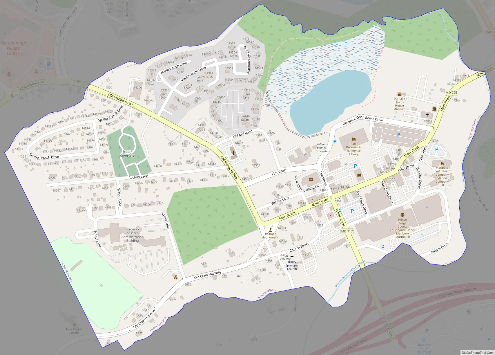
Upper Marlboro Road Map
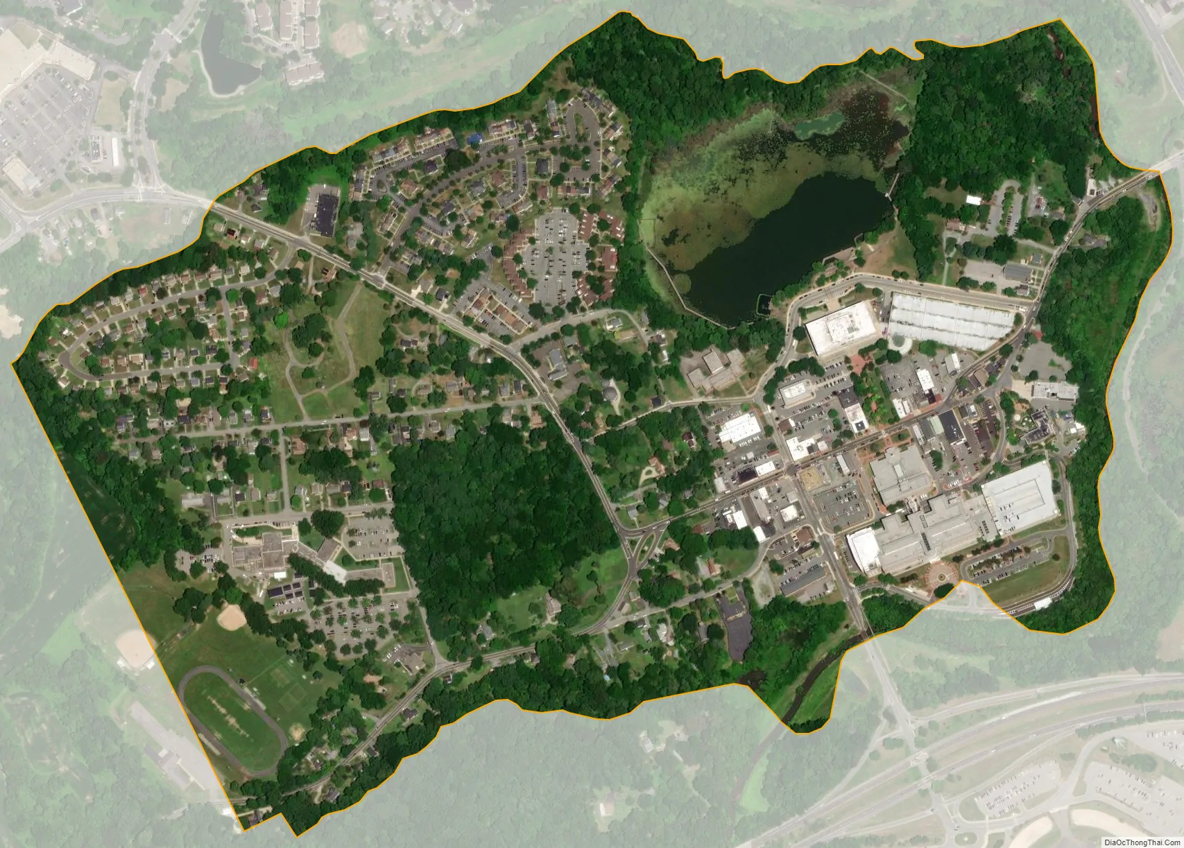
Upper Marlboro city Satellite Map
Geography
Upper Marlboro is located at 38°48′59″N 76°45′12″W / 38.81639°N 76.75333°W / 38.81639; -76.75333 (38.816488, −76.753454).
According to the United States Census Bureau, the town has a total area of 0.43 square miles (1.11 km), of which 0.40 square miles (1.04 km) is land and 0.03 square miles (0.08 km) is water.
Upper Marlboro is the county seat of Prince George’s County, a large urban and suburban area of some 850,000 people adjacent to Washington. U.S. Route 301 and Maryland Route 4 intersect at the edge of town. The northern terminus of the Stephanie Roper Highway (Maryland Route 4) is in Upper Marlboro at the intersection of Pennsylvania Avenue and Water Street. Major features of the town include the courthouse, jail, county office building, board of education, and a lake with a walking path. Just to the south of town is the Prince George’s Equestrian Center which is the location of the annual county fair, a major annual antiques show and The Show Place Arena on the former Marlboro racetrack grounds. This arena is used for events such as hockey games, circuses, rodeos, conventions, trade shows, and graduation ceremonies of many regional high schools, as well as daily overflow parking for county governmental employees, jurors, and visitors.
Although the surrounding area has many rural, pastoral features, including horse farms, housing developments are increasingly prevalent. However, except for supermarkets, an Amish market, car dealers, and a Home Depot, all outside the town limits, the town and surrounding area have only minimal shopping; therefore, residents must travel to Bowie, Clinton, Brandywine, Waldorf, or Forestville to find department stores. Upper Marlboro is convenient to employees commuting to locations along Maryland Route 4 or US Route 301, such as Joint Base Andrews and the U.S. Census Bureau.
The Town of Upper Marlboro is quite small and often confused with the large surrounding unincorporated area known as Greater Upper Marlboro. Greater Upper Marlboro has a population of nearly 20,000 in an area of 77 square miles (200 km), as designated by the post office.
Climate
The climate in this area is characterized by hot, humid summers and generally mild to cool winters. According to the Köppen Climate Classification system, Upper Marlboro has a humid subtropical climate, abbreviated “Cfa” on climate maps.
Bodies of water
Inside of the city of Upper Marlboro, there are three bodies of water: Federal Spring Branch, Western Branch Patuxent River, and School House Pond. Federal Spring Branch flows into the Western Branch Patuxent River nearby Main Street, Upper Marlboro. School House Pond is to the south of the other two bodies.
The branch is approximately two miles long and starts approximately one mile to the west of Upper Marlboro. It splits into four unnamed steams, that join later on. The only bridge over the branch is Old Marlboro Pike, or Maryland Route 725.
School House Pond is a small pond north of Main Street, yet south of Federal Spring Branch. The pond is 12 acres in size, with a 0.75-mile boardwalk around the edge. There is also a walking trail through the small forested area north of the pond. The largest attraction at the pond is fishing. The pond is restocked with 800 trout a year.
The Western Branch Patuxent River is one of the largest tributaries of the Patuxent River. Its flow starts in Woodmore, Maryland, and enters the Patuxent River just a few miles south of Upper Marlboro. The river’s largest tributary south of Upper Marlboro is Collington Branch, which flows into the Western Branch Patuxent River just before entering the Patuxent.
See also
Map of Maryland State and its subdivision: Map of other states:- Alabama
- Alaska
- Arizona
- Arkansas
- California
- Colorado
- Connecticut
- Delaware
- District of Columbia
- Florida
- Georgia
- Hawaii
- Idaho
- Illinois
- Indiana
- Iowa
- Kansas
- Kentucky
- Louisiana
- Maine
- Maryland
- Massachusetts
- Michigan
- Minnesota
- Mississippi
- Missouri
- Montana
- Nebraska
- Nevada
- New Hampshire
- New Jersey
- New Mexico
- New York
- North Carolina
- North Dakota
- Ohio
- Oklahoma
- Oregon
- Pennsylvania
- Rhode Island
- South Carolina
- South Dakota
- Tennessee
- Texas
- Utah
- Vermont
- Virginia
- Washington
- West Virginia
- Wisconsin
- Wyoming


