Map of Vienna town, Maryland
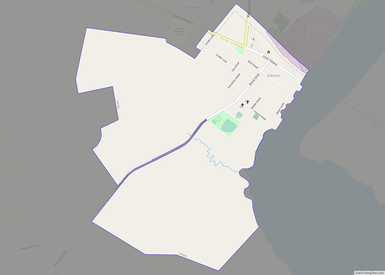
Vienna is a town in Dorchester County, Maryland, United States. The population was 271 at the 2010 census. Vienna town overview: Name: Vienna town LSAD Code: 43 LSAD Description: town (suffix) State: Maryland County: Dorchester County Founded: 1706 Incorporated: 1833 Elevation: 10 ft (3 m) Total Area: 0.77 sq mi (1.98 km²) Land Area: 0.77 sq mi (1.98 km²) Water Area: 0.00 sq mi (0.00 km²) ... Read more
Map of Vienna town, Maryland
Map of West Denton CDP
West Denton is an unincorporated community and census-designated place (CDP) in Caroline County, Maryland, United States. As of the 2010 census it had a population of 52. It is located on the west bank of the Choptank River, across from Denton, the Caroline County seat. Maryland Route 404 Business crosses the Choptank and the oldest ... Read more
Map of West Denton CDP
Map of Waterview CDP
Waterview is an unincorporated community and census-designated place in Wicomico County, Maryland, United States. Its population was 40 as of the 2010 census. It is part of the Salisbury, Maryland-Delaware Metropolitan Statistical Area. Waterview CDP overview: Name: Waterview CDP LSAD Code: 57 LSAD Description: CDP (suffix) State: Maryland County: Wicomico County Elevation: 7 ft (2 m) Total ... Read more
Map of Waterview CDP
Map of Washington Grove town
Washington Grove is a town in Montgomery County, Maryland, United States. The population was 555 at the 2010 United States Census. The Washington Grove Historic District was listed on the National Register of Historic Places in 1980. Washington Grove town overview: Name: Washington Grove town LSAD Code: 43 LSAD Description: town (suffix) State: Maryland County: ... Read more
Map of Washington Grove town
Map of West Pocomoke CDP
West Pocomoke is a census-designated place (CDP) in Somerset County, Maryland, United States. The population was 498 at the 2000 census. It is included in the Salisbury, Maryland-Delaware Metropolitan Statistical Area. West Pocomoke CDP overview: Name: West Pocomoke CDP LSAD Code: 57 LSAD Description: CDP (suffix) State: Maryland County: Somerset County Elevation: 20 ft (6 m) Total ... Read more
Map of West Pocomoke CDP
Map of West Ocean City CDP
West Ocean City CDP overview: Name: West Ocean City CDP LSAD Code: 57 LSAD Description: CDP (suffix) State: Maryland County: Worcester County FIPS code: 2483225 Online Interactive Map West Ocean City online map. Source: Basemap layers from Google Map, Open Street Map (OSM), Arcgisonline, Wmflabs. Boundary Data from Database of Global Administrative Areas. West Ocean ... Read more
Map of West Ocean City CDP
Map of West Laurel CDP
West Laurel is an unincorporated area and census-designated place (CDP) in Prince George’s County, Maryland, United States. Per the 2020 census, the population was 4,428. West Laurel CDP overview: Name: West Laurel CDP LSAD Code: 57 LSAD Description: CDP (suffix) State: Maryland County: Prince George’s County Elevation: 351 ft (107 m) Total Area: 2.36 sq mi (6.13 km²) Land Area: ... Read more
Map of West Laurel CDP
Map of Westernport town
Westernport is a town in Allegany County, Maryland, United States, along the Georges Creek Valley. It is part of the Cumberland, MD-WV Metropolitan Statistical Area. The population was 1,888 at the 2010 census. Westernport town overview: Name: Westernport town LSAD Code: 43 LSAD Description: town (suffix) State: Maryland County: Allegany County Incorporated: 1859 Elevation: 922 ft ... Read more
Map of Westernport town
Map of Westphalia CDP, Maryland
Westphalia is a census-designated place in southern Prince George’s County, Maryland, United States. The population of the CDP was 11,770 at the 2020 census. Westphalia CDP overview: Name: Westphalia CDP LSAD Code: 57 LSAD Description: CDP (suffix) State: Maryland County: Prince George’s County Elevation: 180 ft (50 m) Total Area: 9.91 sq mi (25.68 km²) Land Area: 9.91 sq mi (25.66 km²) Water ... Read more
Map of Westphalia CDP, Maryland
Map of Westminster city, Maryland
Westminster is a city in northern Maryland, United States. It is the seat of Carroll County. The city’s population was 19,960 at the 2020 census. Westminster is an outlying community within the Baltimore-Towson, MD MSA, which is part of a greater Washington-Baltimore-Northern Virginia, DC-MD-VA-WV CSA. Westminster city overview: Name: Westminster city LSAD Code: 25 LSAD ... Read more
Map of Westminster city, Maryland
Map of White Marsh CDP
White Marsh is an unincorporated community and census-designated place in Baltimore County, Maryland, United States. The population was 9,513 at the 2010 census. White Marsh is a northeast suburb of Baltimore. White Marsh CDP overview: Name: White Marsh CDP LSAD Code: 57 LSAD Description: CDP (suffix) State: Maryland County: Baltimore County Founded: 1965 Elevation: 52 ft ... Read more
Map of White Marsh CDP
Map of Wheaton CDP, Maryland
Wheaton is a census-designated place in Montgomery County, Maryland, United States, situated north of Washington, D.C., and northwest of downtown Silver Spring. Wheaton takes its name from Frank Wheaton (1833–1903), a career officer in the United States Army and volunteer from Rhode Island in the Union Army who rose to the rank of major-general while ... Read more
Map of Wheaton CDP, Maryland