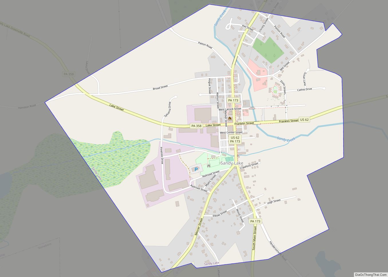
Map of Salladasburg borough
Salladasburg is a borough in Lycoming County, Pennsylvania, United States. The population was 252 at the 2020 census, making it the smallest borough in Lycoming County. It is part of the Williamsport, Pennsylvania Metropolitan Statistical Area. Salladasburg is located on Larrys Creek, at the confluence of the Second Fork of Larrys Creek. It is also ... Read more
Map of Salladasburg borough
Map of Salisbury borough, Pennsylvania
Salisbury borough overview: Name: Salisbury borough LSAD Code: 21 LSAD Description: borough (suffix) State: Pennsylvania County: Somerset County FIPS code: 4267584 Online Interactive Map Salisbury online map. Source: Basemap layers from Google Map, Open Street Map (OSM), Arcgisonline, Wmflabs. Boundary Data from Database of Global Administrative Areas. Salisbury location map. Where is Salisbury borough? Salisbury ... Read more
Map of Salisbury borough, Pennsylvania
Map of Sandy CDP, Pennsylvania
Sandy is a census-designated place (CDP) in Clearfield County, Pennsylvania, United States. The population was 1,362 at the 2020 census. Sandy CDP overview: Name: Sandy CDP LSAD Code: 57 LSAD Description: CDP (suffix) State: Pennsylvania County: Clearfield County Elevation: 1,430 ft (440 m) Total Area: 1.4 sq mi (3.6 km²) Land Area: 1.4 sq mi (3.6 km²) Total Population: 1,362 Population Density: 1,031/sq mi ... Read more
Map of Sandy CDP, Pennsylvania
Map of Sandy Ridge CDP
Sandy Ridge is an unincorporated community and census-designated place (CDP) in Centre County, Pennsylvania, United States. It is part of the State College, Pennsylvania Metropolitan Statistical Area. The population was 407 at the 2010 census. Sandy Ridge CDP overview: Name: Sandy Ridge CDP LSAD Code: 57 LSAD Description: CDP (suffix) State: Pennsylvania County: Centre County ... Read more
Map of Sandy Ridge CDP
Map of Schaefferstown CDP
Schaefferstown (Pennsylvania German: Schaefferschteddel) is an unincorporated community and census-designated place (CDP) in Heidelberg Township, Lebanon County, Pennsylvania, United States. The population was 941 at the 2010 census. Schaefferstown CDP overview: Name: Schaefferstown CDP LSAD Code: 57 LSAD Description: CDP (suffix) State: Pennsylvania County: Lebanon County Elevation: 585 ft (178 m) Total Area: 2.68 sq mi (6.95 km²) Land Area: ... Read more
Map of Schaefferstown CDP
Map of Scalp Level borough
Scalp Level is a borough in Cambria County, Pennsylvania, United States. It is part of the Johnstown, Pennsylvania Metropolitan Statistical Area. The population was 778 at the 2010 census. Scalp Level borough overview: Name: Scalp Level borough LSAD Code: 21 LSAD Description: borough (suffix) State: Pennsylvania County: Cambria County Incorporated: 1898 Elevation: 1,703 ft (519 m) Total ... Read more
Map of Scalp Level borough
Map of Sayre borough, Pennsylvania
Sayre is a borough in Bradford County, Pennsylvania, United States. It is part of Northeastern Pennsylvania. It is the principal city in the Sayre, PA Micropolitan Statistical Area. It lies 18 miles (29 km) southeast of Elmira, New York, and 30 miles (48 km) southwest of Binghamton. It is currently the largest city in Bradford County. In ... Read more
Map of Sayre borough, Pennsylvania
Map of Saylorsburg CDP
Saylorsburg is a census-designated place and unincorporated community in Monroe County, Pennsylvania, United States. Saylorsburg is located off Pennsylvania Route 33, 5 miles (8.0 km) northwest of Wind Gap. As of the 2010 census, its population was 1,126. The village is located in both Ross Township and Hamilton Township. Saylorsburg is in the Pocono Mountains. One ... Read more
Map of Saylorsburg CDP
Map of Saxton borough
Saxton is a borough in Bedford County, Pennsylvania, United States. The population was 722 at the 2020 census. Saxton borough overview: Name: Saxton borough LSAD Code: 21 LSAD Description: borough (suffix) State: Pennsylvania County: Bedford County Incorporated: 1867 Elevation: 1,716 ft (523 m) Total Area: 0.41 sq mi (1.05 km²) Land Area: 0.41 sq mi (1.05 km²) Water Area: 0.00 sq mi (0.00 km²) Total Population: ... Read more
Map of Saxton borough
Map of Saxonburg borough
Saxonburg is a borough in Butler County, Pennsylvania, United States. It is part of the Pittsburgh metropolitan area in the western part of the state. It was founded in 1832 by F. Carl Roebling and his younger brother John as a German farming colony. The population of Saxonburg was 1,525 as of the 2010 census. ... Read more
Map of Saxonburg borough
Map of Saw Creek CDP
Saw Creek is a census-designated place and Private community located mainly in Lehman Township in Pike County, Pennsylvania, United States, as well as a small portion located in Middle Smithfield Township in Monroe County in Pennsylvania. As of the 2010 census the population was 4,016 residents. Saw Creek CDP overview: Name: Saw Creek CDP LSAD ... Read more
Map of Saw Creek CDP
Map of Sankertown borough
Sankertown is a borough in Cambria County, Pennsylvania, United States. It is part of the Johnstown, Pennsylvania Metropolitan Statistical Area. The population was 675 at the 2010 census. Sankertown borough overview: Name: Sankertown borough LSAD Code: 21 LSAD Description: borough (suffix) State: Pennsylvania County: Cambria County Incorporated: 1906 Elevation: 2,060 ft (630 m) Total Area: 0.29 sq mi (0.76 km²) ... Read more
Map of Sankertown borough